Surveyors Lookout
Closed for the season. The lookout typically operates from mid-July through the end of September. Reservations are available through Recreation.gov.
Air Quality Alert issued July 20 at 12:33PM PDT by NWS Spokane WA
An Air Quality Alert has been cancelled by the following agencies: Idaho Department of Environmental Quality in Coeur d'Alene Coeur d'Alene Tribe Idaho Department of Environmental Quality in Lewiston Nez Perce Tribe
Air Quality Alert issued July 20 at 12:33PM PDT by NWS Spokane WA
An Air Quality Alert has been cancelled by the following agencies: Idaho Department of Environmental Quality in Coeur d'Alene Coeur d'Alene Tribe Idaho Department of Environmental Quality in Lewiston Nez Perce Tribe
Air Quality Alert issued July 20 at 10:43AM PDT by NWS Spokane WA
An Air Quality Alert has been issued by the following agencies: Idaho Department of Environmental Quality in Coeur d'Alene Coeur d'Alene Tribe Environmental Protection Agency * WHAT...Air Quality Advisory due to wildfire smoke. Air Quality Index is forecasted to be Unhealthy for Sensitive Groups. For the latest air quality readings, head to https://fire.airnow.gov or visit the Idaho Smoke Blog at www.idsmoke.blogspot.com. * WHERE...Boundary County, Bonner, Kootenai, Shoshone, Benewah Counties. * WHEN...Next update by 12 PM Monday, July 20th. * IMPACTS...Some members of the public may experience health effects; members of sensitive groups may experience more serious health effects.
About
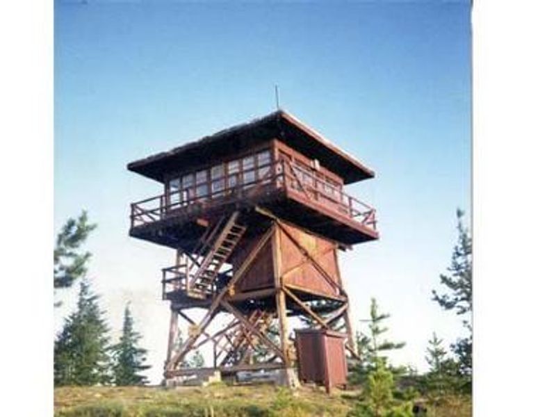
Surveyors Lookout offers a unique overnight experience in a historic fire lookout tower within the Idaho Panhandle National Forests. Built in 1931 as part of a network of lookouts used to spot fires in the Upper St. Joe Country, the original pole structure was replaced with the current treated timber tower in 1964. The 30-foot tower is listed on the National Historic Lookout Register and provides phenomenal views of Snow Peak and the surrounding Mallard-Larkins Pioneer Area. The lookout accommodates up to four guests and is furnished with a twin bed, two extra mattresses, chest of drawers, a small refrigerator (noted as unreliable), propane cook stove, propane heater with lights, cooking pots and utensils, and a rodent-proof food container. No drinking water is available at the facility; guests must bring their own or collect water from a spring 1.4 miles down the access road (non-potable, requires boiling or treatment). A vault toilet is located on site. The lookout provides access to several trails including Scribner Falls Trail #106, Surveyor's Ridge Trail #40, Horseshoe Loop Trail #141, and Northbound Creek Trail #111. The area offers hunting and trout fishing in designated areas. Avery is the nearest town for supplies and conveniences. Access requires navigating a rugged single-lane road with pullouts that is not recommended for low clearance vehicles and may be slick when wet.
Directions
From the St. Joe River Road (FH50) to Beaver Creek: Drive 29 miles east of Avery to the junction of Red Ives Road 218. Turn south (right) and drive 8 miles to the junction of Beaver Creek Road 303 (just past Beaver Creek Campground). Drive about 7.5 miles to Road 201. Turn south (left) toward Sawtooth Saddle. Drive 13 miles to the access road to Surveyors Lookout (Road 395A). Turn right and follow the access road approximately 0.5 mile to the lookout. Access is via a rugged single-lane road with pullouts, not recommended for low clearance vehicles.
Location
Amenities
| Water | No |
| Fires Allowed | — |
| Toilets | Yes |
| Dump Station | No |
| Wifi | No |
| Pets Allowed | — |
| Showers | No |
| Electric Hookups | — |
| Water Hookups | — |
| Sewer Hookups | — |
| Camp Store | No |
| Price | $55 |
Vehicle
| Max RV Length | — |
| Max Trailer Length | — |
| Big Rig Friendly | No |
| Pull Through Sites | No |
Contact
| Phone | +1 (208) 245-4517 |
Cell Service
| AT&T | None |
| Verizon | None |
| T-Mobile | None |
Availability
Photos
Community Posts
No posts yet. Be the first to share your experience!