Lost Prairie Group Site
Closed for the season. Opens late May 2026 and operates through October. Reservations available via Recreation.gov up to 12 months in advance. When not reserved as a group site, individual sites 1-4 are available first-come, first-served.
Alcohol Prohibitions
This Order describes acts that are prohibited upon lands, roads and trails within the National Forest System administered by the Forest Service Pacific Northwest Region in regards to alcoholic beverages.
Aquatic Invasive Species
This Order prohibits 1) possessing, storing, or transporting any aquatic invasive animal species AND 2) prohibits possessing, storing, or transporting any aquatic or riparian invasive plant species - on National Forest System lands in the Pacific Northwest Region as specified in the Order.
Restrictions on Use of Forage and Mulch Products
This Order prohibits unloading, storing, or using any straw, hay, grain, seed, or other forage or mulch products that are not state-certified weed free on the National Forest System lands, roads or trails in any Closure Area as specific in the Order. Some examples of these include hay bales, hay…
Fireworks and Explosives are always Prohibited
Fireworks and explosives (including explosive targets) are always prohibited on national forest lands. The prohibition of fireworks and exploding targets on national forest system lands is part of a set of permanent fire safety regulations in the Code of Federal Regulations (CFR), listed below.…
Road over Detroit Dam closed May 8- 21
The U.S. Army Corps of Engineers is closing the road over Detroit Dam from Friday, May 8 until Thursday, May 21 for dam inspections and maintenance. No vehicles will be able to pass over the dam during this time period. Visitors will not be able to cross the dam to access Forest Service roads,…
Cedar Creek Fire Closure
To provide for public safety, a closure order is in place for the following areas impacted by the Cedar Creek Fire.
Terwilliger Hot Springs Nudity, Alcohol, and Closed Times
The following is prohibited: to park or possess an alcoholic beverage in restricted areas, be publicly nude visible from Forest Road 19, and to enter or use Terwilliger Hot Springs between 10 p.m. and sunrise.
Portion of Forest Service Road 1003 (Tom Creek Road) closed
A portion of Forest Service Road 1003, also known as Tom Creek Road, is closed. The road closure starts at the junction of FSR 10 and FSR 1003 and includes the first 4.1 miles of FSR 1003 to the junction with the 1003-416 and 1003-409 roads.
Emigrant Fire Closure Order
Pursuant to 16 USC 551 and 36 CFR § 261.50 (a) and (b), and to provide for public safety, the following acts are prohibited in the areas described in this Order on National Forest System lands within the administrative boundaries of the Willamette National Forest. This Order…
Tamolitch Parking / Trail Construction Closure
Tamolitch Parking and Trail Construction Closure Forest Order.Forest roads 2600-735, 2600-738, and 2600-739: and the area is described as beginning at the junction of Highway 126 and 2600-735 road, west along the 2600-735 road, then northwest to the highwater mark of the east bank of the McKenzie…
Detroit Dispersed Camping Restrictions
Pursuant to 16 USC§ 551 and 36 CFR 261.50(a) and (b), and to provide for public safety, the following acts are prohibited in the Closure Areas, roads and their associated spur roads, trailheads, and recreation sites described in this order on National Forest System lands within the administrative…
FIRE CLOSURES: Current wildfire closures on the Willamette National Forest
For updates on active fires, visit our fire Incident Information page. Fire Closures:Cedar Creek Fire Closure Order & Map (updated 3/23/26)Beachie Creek and Lionshead Fires Closure Order & Map (updated 05/22/25)Map of All Fire Closures in Pacific Northwest
Beachie Creek and Lionshead Fires Closure
Pursuant to 16 USC § 551 and 36 CFR § 261.50(a) and (b), and to provide for public safety, the following acts are prohibited in the roads and their associated spur roads, trailheads, and recreation sites described in this order on National Forest System lands within the administrative boundaries…
14 Day Stay Camping Limit
Camping, occupying, or otherwise leaving camping equipment and/or related supplies at any locations on the Willamette National Forest described in this order, overnight, for a period longer than 14 calendar days, in a 30-day period.
Camping Restrictions in Cougar Recreation Area
The Cougar Recreation Area is a specially designated area around Cougar Reservoir. It includes a 1/2-mile strip on either side of Forest Service Road 19 from Hwy 126 to Forest Service Road 1927 as well as Terwilliger Hot Springs, Hidden Lake Day Use Area, areas surrounding Delta Campground, Slide…
Moose and Gordon Dispersed Camping Closure
The purpose of this closure is to prohibit dispersed overnight camping and make these areas available as day-use only. This is to allow river access for all users, reduce conflict, reduce safety concerns, reduce and eliminate health and sanitation issues associated with improper disposal of human…
Special Wilderness Permit, Camping and Fire Restrictions
This outlines special restrictions on the Willamette and Deschutes National Forests.
Occupation Use Restriction in Middle Fork Ranger District
The following acts are prohibited in the areas described in this order within the administrative boundaries of the Willamette National Forest.Prohibitions:1. Being in the area after sundown to before sunrise.2. Parking in violation of posted instructions.
About
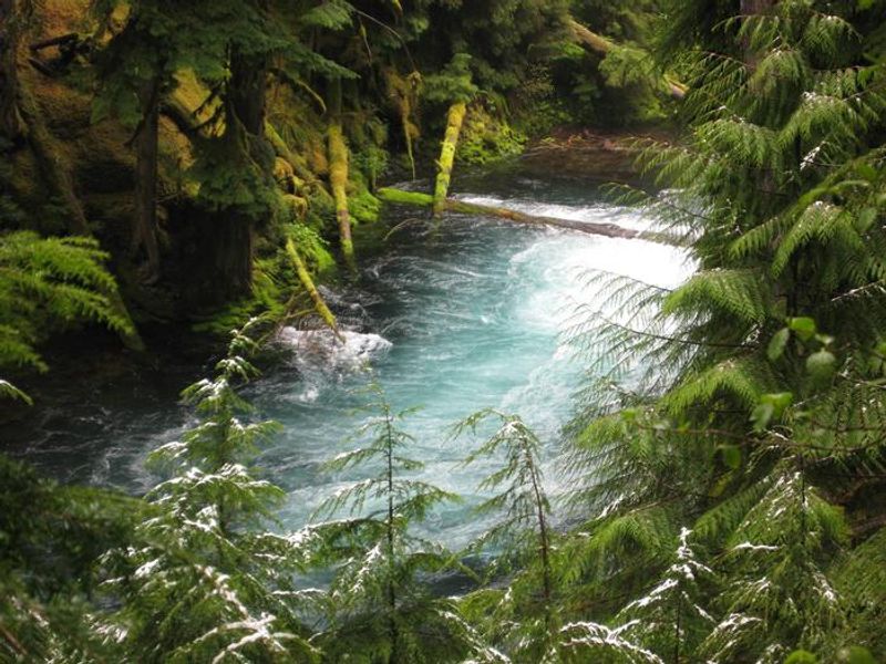
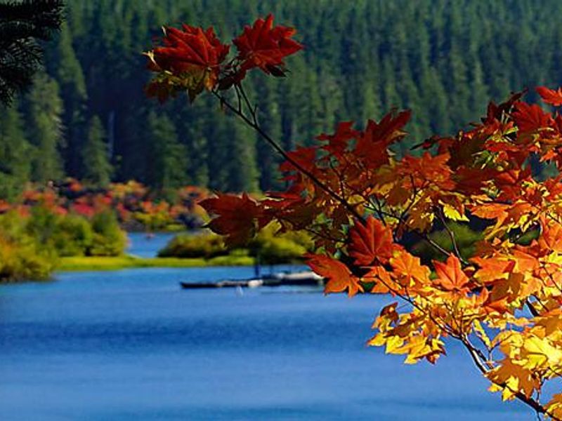
Lost Prairie Group Site sits at 3,600 feet in the Willamette National Forest along the Over the Rivers and Through the Woods Scenic Byway. The campground occupies a natural meadow near Hackleman Creek, historically part of the Santiam Wagon Road where a scouting party famously became lost before spotting Sand Mountain. Summer brings wildflowers blooming in the prairie, and the creek is accessible from the campground. The site accommodates up to 75 people across 10 campsites. Sites 1-4 are paved back-in sites suitable for RVs and trailers ranging from 15 to 42 feet depending on the site. Sites 5-10 are former walk-in sites within 60 feet of the main area, ideal for tent camping. A paved parking area accommodates up to 6 RVs. Each site has a picnic table and fire pit. Two double vault toilets serve the campground, including one ADA-accessible unit near the parking area, plus an older outhouse near site 1. Drinking water is available from a hand pump well. The location offers excellent access to outdoor recreation. The McKenzie River National Scenic Trail is 15 minutes away, and Clear Lake, known for its exceptional clarity and submerged standing trees from the Sand Mountain eruption, is nearby with a resort offering boat rentals and dining. Iron Mountain, Echo Basin, Crescent Mountain, and Browder Ridge trails are all within a short drive, while Smith Reservoir and Suttle Lake provide additional boating and fishing opportunities.
Directions
From Sweet Home, OR, follow Highway 20 east for 38 miles and look for signs for the Lost Prairie Group Site on the right.
Amenities
| Water | Yes |
| Fires Allowed | Yes |
| Toilets | Yes |
| Dump Station | No |
| Wifi | No |
| Pets Allowed | Yes |
| Showers | No |
| Electric Hookups | — |
| Water Hookups | — |
| Sewer Hookups | — |
| Camp Store | No |
| Price | $225 |
Vehicle
| Max RV Length | 42ft |
| Max Trailer Length | 42ft |
| Big Rig Friendly | Yes |
| Pull Through Sites | No |
Contact
| Phone | +1 (541) 367-5168 |
Cell Service
| AT&T | None |
| Verizon | None |
| T-Mobile | None |
Availability
Photos
Community Posts
No posts yet. Be the first to share your experience!