Little Crater Lake
The campground opens for the 2026 season on May 22. Season runs through late September. Some sites are first-come, first-served early in the season, with reservations available through Recreation.gov starting late May.
Alcohol Prohibitions
This Order describes acts that are prohibited upon lands, roads and trails within the National Forest System administered by the Forest Service Pacific Northwest Region in regards to alcoholic beverages.
Aquatic Invasive Species
This Order prohibits 1) possessing, storing, or transporting any aquatic invasive animal species AND 2) prohibits possessing, storing, or transporting any aquatic or riparian invasive plant species - on National Forest System lands in the Pacific Northwest Region as specified in the Order.
Restrictions on Use of Forage and Mulch Products
This Order prohibits unloading, storing, or using any straw, hay, grain, seed, or other forage or mulch products that are not state-certified weed free on the National Forest System lands, roads or trails in any Closure Area as specific in the Order. Some examples of these include hay bales, hay…
Fireworks and Explosives are always Prohibited
Fireworks and explosives (including explosive targets) are always prohibited on national forest lands. The prohibition of fireworks and exploding targets on national forest system lands is part of a set of permanent fire safety regulations in the Code of Federal Regulations (CFR), listed below.…
Prescribed burning near Rock Creek Reservoir
Forest wildland fire staff will be conducting a very small prescribed burn near Camp Cody and Rock Creek this week, with post-burn patrol continuing through the weekend. Recent rain and higher relative humidity levels have allowed fire staff to conduct this burn safely before the summer begins.…
Erosion hazards on Pioneer Bridle Trail
Caution: Pioneer Bridle Trail has heavy damage in multiple sections due to erosion from winter storms. Deep ruts could be dangerous for mountain bikers and other users. Bikers should be prepared to dismount for stretches. Trails staff have flagged and signed a particularly dangerous section of…
Tamanawas Falls Trail #650A is CLOSED
Tamanawas Falls Trail #650A is CLOSED due to heavy damage from the December storms. Tamanawas Falls Trail #650A is blocked by multiple slides and completely washed out and destroyed in one section, making Tamanawas Falls inaccessible via that route. The nearby East Fork Trail #650 also has a bridge…
Hazards from Winter Storms
Heavy rains and strong winds created many hazards across Mt. Hood National Forest and surrounding areas during December storms. Although the storms have passed, conditions across the Forest may still be unsafe. Multiple trails and recreation sites across the Clackamas River, Hood River, and Zigzag…
Eagle Creek Fire Area Closures
In 2017, the Eagle Creek Fire caused extensive damage to surrounding areas in Columbia River Gorge and parts of Mt. Hood National Forest. Some trails are closed to the public in both the Gorge and Hood River Ranger District, pursuant to 16 USC § 551 and 36 CFR 261.50 (a) and (b). This closure is…
Health and Safety Closure Due to Roadside Danger Trees
This Order prohibits using any type of motor vehicle upon the following NFS Roads as described: 1) NFS Road 45 (Memaloose Road) from the bridge at highway 224 to the junction with NFS Road 45-310 and 2) NFS Road 54 from the highway 224 junction (at the bridge gate) to NFS Road 5410.
Bull Run Watershed Closure
This Order prohibits 1) Going into or being upon the area which is closed for the protection of public health or safety, 2) Being on a road, 3) Being on a trail within the area described in Exhibit A, except to travel on the Pacific Crest National Scenic Trail #2000 and Huckleberry Trail #617, and…
Camping Stay Restrictions
This Order prohibits 1) Camping in a single location for a period longer than 14 consecutive days and 2) Camping at any location for more than 28 days total during a calendar year on all National Forest System lands as described in this order.
Crane Creek bridge closed on the Barlow Road
The Crane Creek bridge on the Barlow Road (Forest Road 3530) is collapsed and closed. The Barlow Road is open, but it can't be driven from end to end.Crane Creek bridgeLocated approximately 0.4 miles east of the Forest Road 4885-Barlow Road junction.There are temporary barricades and signage…
Sportsman's Park Fire & Occupancy Restrictions
This Forest Order prohibits 1) Building, maintaining, attending or using a fire, campfire, or stove fire and 2) Camping on the Mt. Hood National Forest, Barlow Ranger District; T4S, R11E, Multiple Sections - Sportsman's Park Wildland Urban Interface Zone.
Gordon Creek Watershed Restrictions
This Order prohibits 1) Using a motor vehicle on Forest development roads, except Forest Road 15, which is also known as Larch Mt Road, 2) Using a motor vehicle on Forest development trails, 3) Possessing or using a motor vehicle off Forest development roads, and 4) Camping within the Gordon Creek…
The Dalles Watershed Closure
This Order prohibits visitors from entering or being on the roads or trails of The Dalles Watershed.
About
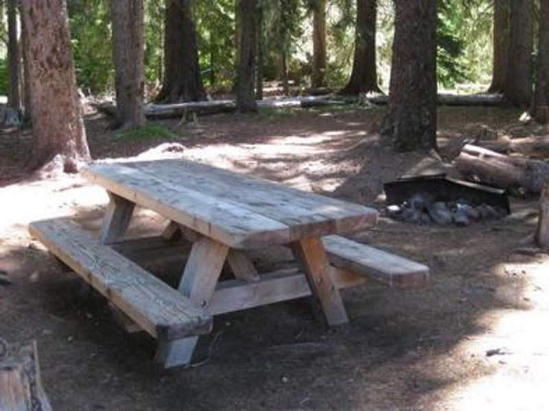
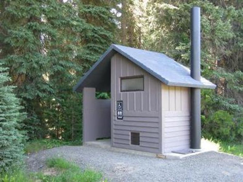
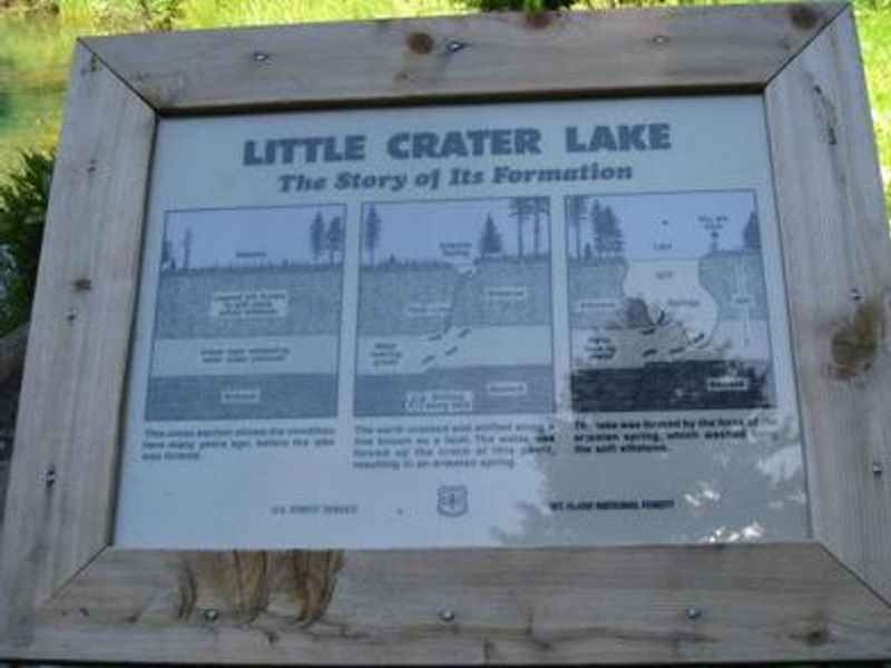
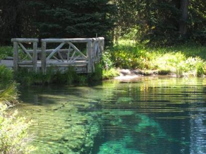
Little Crater Lake Campground is one of the most scenic spots in Mt. Hood National Forest. Set in a quiet evergreen forest at 3,300 feet elevation, the campground provides comfortable tent and small RV camping with about 15 single-family sites. Each site includes a picnic table and campfire ring with grill. Accessible vault toilets and a hand-pump water spigot near the entrance serve the facility. The campground's namesake, Little Crater Lake, is a geologic oddity thought to have formed when artesian water forced its way through soft volcanic rock. The small, spring-fed pond features crystal-clear turquoise water that remains cold year-round. A short viewing trail begins in the campground and connects to the Pacific Crest National Scenic Trail. Swimming is strictly prohibited to protect the lake's sensitive ecological features. Timothy Lake, a 1,400-acre reservoir popular for boating and fishing, is nearby. Anglers will find Kokanee salmon and stocked trout. The surrounding meadows offer excellent huckleberry picking in season and good wildlife viewing opportunities.
Directions
From Sandy, travel southeast on Highway 26 past Government Camp and Frog Lake to Forest Road 42. Follow Road 42 south approximately 4 miles to Forest Road 58. Turn right and travel northwest about 2 miles to the campground.
Nearby Campgrounds
Amenities
| Water | Yes |
| Fires Allowed | Yes |
| Toilets | Yes |
| Dump Station | No |
| Wifi | No |
| Pets Allowed | Yes |
| Showers | No |
| Electric Hookups | — |
| Water Hookups | — |
| Sewer Hookups | — |
| Camp Store | No |
| Price | $26 |
Vehicle
| Max RV Length | 26ft |
| Max Trailer Length | 26ft |
| Big Rig Friendly | No |
| Pull Through Sites | No |
Contact
| Phone | +1 (503) 622-3191 |
Cell Service
| AT&T | None |
| Verizon | None |
| T-Mobile | None |
Availability
Photos
Community Posts
No posts yet. Be the first to share your experience!