Clear Lake

Clear Lake Cabin Lookout

Open

Open and available for reservations through May 31, 2026. Currently fully booked through mid-May. From December 1 through April 30, access requires skiing, snowshoeing, or snowmobiling 3.5 miles from Skyline Sno-Park with an ODOT Sno-Park permit. Maximum stay is 7 consecutive nights.

Alcohol Prohibitions

This Order describes acts that are prohibited upon lands, roads and trails within the National Forest System administered by the Forest Service Pacific Northwest Region in regards to alcoholic beverages.

Aquatic Invasive Species

This Order prohibits 1) possessing, storing, or transporting any aquatic invasive animal species AND 2) prohibits possessing, storing, or transporting any aquatic or riparian invasive plant species - on National Forest System lands in the Pacific Northwest Region as specified in the Order.

Restrictions on Use of Forage and Mulch Products

This Order prohibits unloading, storing, or using any straw, hay, grain, seed, or other forage or mulch products that are not state-certified weed free on the National Forest System lands, roads or trails in any Closure Area as specific in the Order. Some examples of these include hay bales, hay…

Fireworks and Explosives are always Prohibited

Fireworks and explosives (including explosive targets) are always prohibited on national forest lands. The prohibition of fireworks and exploding targets on national forest system lands is part of a set of permanent fire safety regulations in the Code of Federal Regulations (CFR), listed below.…

Prescribed burning near Rock Creek Reservoir

Forest wildland fire staff will be conducting a very small prescribed burn near Camp Cody and Rock Creek this week, with post-burn patrol continuing through the weekend. Recent rain and higher relative humidity levels have allowed fire staff to conduct this burn safely before the summer begins.…

Erosion hazards on Pioneer Bridle Trail

Caution: Pioneer Bridle Trail has heavy damage in multiple sections due to erosion from winter storms. Deep ruts could be dangerous for mountain bikers and other users. Bikers should be prepared to dismount for stretches. Trails staff have flagged and signed a particularly dangerous section of…

Tamanawas Falls Trail #650A is CLOSED

Tamanawas Falls Trail #650A is CLOSED due to heavy damage from the December storms. Tamanawas Falls Trail #650A is blocked by multiple slides and completely washed out and destroyed in one section, making Tamanawas Falls inaccessible via that route. The nearby East Fork Trail #650 also has a bridge…

Hazards from Winter Storms

Heavy rains and strong winds created many hazards across Mt. Hood National Forest and surrounding areas during December storms. Although the storms have passed, conditions across the Forest may still be unsafe. Multiple trails and recreation sites across the Clackamas River, Hood River, and Zigzag…

Eagle Creek Fire Area Closures

In 2017, the Eagle Creek Fire caused extensive damage to surrounding areas in Columbia River Gorge and parts of Mt. Hood National Forest. Some trails are closed to the public in both the Gorge and Hood River Ranger District, pursuant to 16 USC § 551 and 36 CFR 261.50 (a) and (b). This closure is…

Health and Safety Closure Due to Roadside Danger Trees

This Order prohibits using any type of motor vehicle upon the following NFS Roads as described: 1) NFS Road 45 (Memaloose Road) from the bridge at highway 224 to the junction with NFS Road 45-310 and 2) NFS Road 54 from the highway 224 junction (at the bridge gate) to NFS Road 5410.

Bull Run Watershed Closure

This Order prohibits 1) Going into or being upon the area which is closed for the protection of public health or safety, 2) Being on a road, 3) Being on a trail within the area described in Exhibit A, except to travel on the Pacific Crest National Scenic Trail #2000 and Huckleberry Trail #617, and…

Camping Stay Restrictions

This Order prohibits 1) Camping in a single location for a period longer than 14 consecutive days and 2) Camping at any location for more than 28 days total during a calendar year on all National Forest System lands as described in this order.

Crane Creek bridge closed on the Barlow Road

The Crane Creek bridge on the Barlow Road (Forest Road 3530) is collapsed and closed. The Barlow Road is open, but it can't be driven from end to end.Crane Creek bridge​Located approximately 0.4 miles east of the Forest Road 4885-Barlow Road junction.There are temporary barricades and signage…

Sportsman's Park Fire & Occupancy Restrictions

This Forest Order prohibits 1) Building, maintaining, attending or using a fire, campfire, or stove fire and 2) Camping on the Mt. Hood National Forest, Barlow Ranger District; T4S, R11E, Multiple Sections - Sportsman's Park Wildland Urban Interface Zone.

Gordon Creek Watershed Restrictions

This Order prohibits 1) Using a motor vehicle on Forest development roads, except Forest Road 15, which is also known as Larch Mt Road, 2) Using a motor vehicle on Forest development trails, 3) Possessing or using a motor vehicle off Forest development roads, and 4) Camping within the Gordon Creek…

The Dalles Watershed Closure

This Order prohibits visitors from entering or being on the roads or trails of The Dalles Watershed.

About

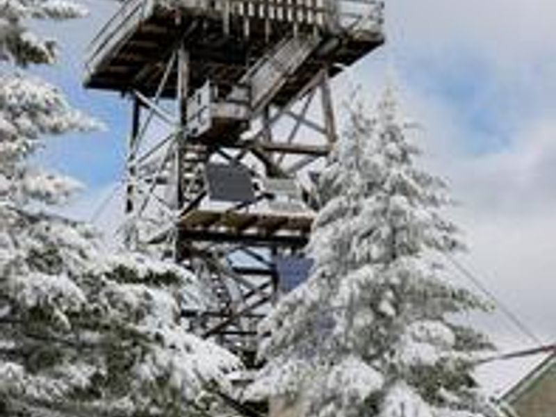
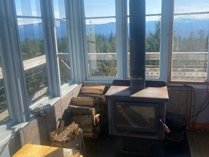
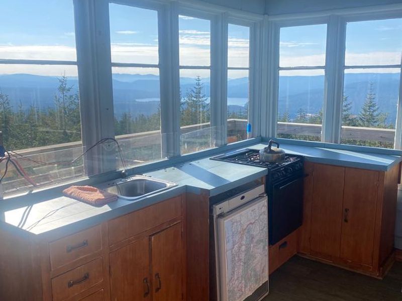
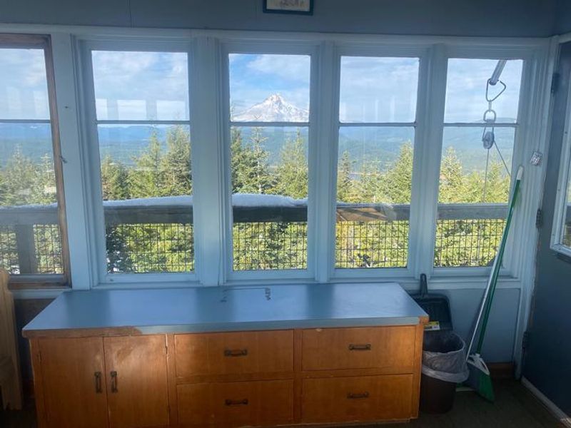
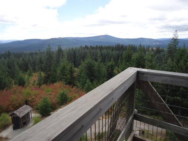
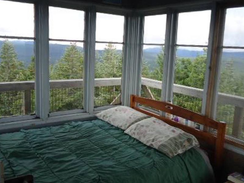
Clear Lake Cabin Lookout is one of three Forest Service fire lookout towers on Mt. Hood, still used for fire spotting during summer months and available as a winter rental November through May. The tower sits on Clear Lake Butte near the northwest corner of the Warm Springs Indian Reservation, overlooking Clear Lake and Timothy Lake in the distance. Originally built in 1932 at 100 feet tall, the current 40-foot R-6 Flat Top style structure was constructed in 1962. The 14x14 foot cabin is furnished with a small single bed, wood stove for heating, table and chair, propane cook stove, and solar-powered lighting system. An outhouse with vault toilet is located nearby, along with a shed stocked with firewood and a rope and pulley system for hauling gear up the tower. Guests must bring their own water, bedding, food, toilet paper, and garbage bags, as there is no potable water on site and all trash must be packed out. From December 1 through April 30, or whenever winter driving conditions exist, access requires skiing, snowshoeing, or snowmobiling 3.2-3.5 miles from Skyline Sno-Park on Highway 26. An ODOT Sno-Park permit is required to park. The trek follows Forest Service Road 42 to the 240 spur road with 900 feet of elevation gain, typically taking 3.5-4 hours for moderate skiers. Visitors should be experienced in backcountry travel and prepared for extreme weather conditions.

Directions

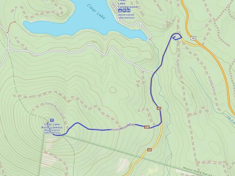
From the junction of Highway 26 and Forest Service Road 42, 12 miles south of Government Camp, Oregon. Park at Skyline Sno-Park (Sno-Park permit required Nov 1 - Apr 30). Proceed on FS Road 42 to the 240 spur road to the lookout, approximately 3.2 miles with 900 feet elevation gain. From December 1 through April 30, or during winter driving conditions, access is by ski, snowshoe, or snowmobile only.

Amenities

Water No
Fires Allowed
Toilets Yes
Dump Station No
Wifi No
Pets Allowed No
Showers No
Electric Hookups
Water Hookups
Sewer Hookups
Camp Store No
Price $85

Vehicle

Max RV Length
Max Trailer Length
Big Rig Friendly No
Pull Through Sites No

Contact

Phone +1 (541) 467-2291

Cell Service

AT&T Yes
Verizon Yes
T-Mobile Yes

Availability

Photos

Clear Lake
Map showing route from Skyline Sno-Park to Clear Lake Lookout.
Clear Lake lookout wood stove.
Clear Lake lookout kitchen area.
View of Mt. Hood from inside Clear Lake lookout.
View from Clear Lake Cabin Lookout.
Clear Lake Lookout sleeping area.

Community Posts

No posts yet. Be the first to share your experience!