Horseshoe Bend Hiker-biker Campsite
Open year-round, first-come first-served with no fee. One-night limit per trip. Non-potable water is available mid-April through mid-November and must be filtered or boiled before use. Water is turned off mid-November through mid-April.
About
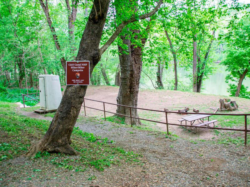
Horseshoe Bend Hiker-Biker Campsite sits at Mile 79.2 on the C&O Canal towpath in Washington County, Maryland. Part of a network of primitive hiker-biker sites spaced every 5-7 miles along the 184.5-mile canal, it provides a convenient overnight stop for long-distance hikers and cyclists traveling the towpath. The site includes a chemical toilet available year-round, a picnic table, and a fire pit or grill. Non-potable well water is available from mid-April through mid-November but must be filtered, chemically treated, or boiled before drinking. Well handles are removed during winter to prevent freeze damage. This is a pack-it-out park with no trash facilities. No fee or reservation is required. Stays are limited to one night per site per trip. Fires must be contained to the provided fire rings or grills, or portable grills elevated off the ground, and coals must be extinguished and removed. Pets are permitted but must remain leashed. The site is not ADA accessible and is reached only by foot or bicycle along the towpath.
Directions
Located at mile 79.2 on the C&O Canal towpath near Mercersville, Maryland. Accessible only by foot or bicycle along the towpath.
Nearby Campgrounds
Amenities
| Water | No |
| Fires Allowed | Yes |
| Toilets | Yes |
| Dump Station | No |
| Wifi | No |
| Pets Allowed | Yes |
| Showers | No |
| Electric Hookups | — |
| Water Hookups | — |
| Sewer Hookups | — |
| Camp Store | No |
| Price | $0 |
Vehicle
| Max RV Length | — |
| Max Trailer Length | — |
| Big Rig Friendly | No |
| Pull Through Sites | No |
Contact
| CHOH_information@nps.gov | |
| Phone | +1 (301) 739-4200 |
Cell Service
| AT&T | None |
| Verizon | None |
| T-Mobile | None |
Photos

Community Posts
No posts yet. Be the first to share your experience!