Gold Butte Lookout
Closed for the season. The lookout typically opens in early July and operates through mid-October, weather permitting. Reservations are required through Recreation.gov.
Alcohol Prohibitions
This Order describes acts that are prohibited upon lands, roads and trails within the National Forest System administered by the Forest Service Pacific Northwest Region in regards to alcoholic beverages.
Aquatic Invasive Species
This Order prohibits 1) possessing, storing, or transporting any aquatic invasive animal species AND 2) prohibits possessing, storing, or transporting any aquatic or riparian invasive plant species - on National Forest System lands in the Pacific Northwest Region as specified in the Order.
Restrictions on Use of Forage and Mulch Products
This Order prohibits unloading, storing, or using any straw, hay, grain, seed, or other forage or mulch products that are not state-certified weed free on the National Forest System lands, roads or trails in any Closure Area as specific in the Order. Some examples of these include hay bales, hay…
Fireworks and Explosives are always Prohibited
Fireworks and explosives (including explosive targets) are always prohibited on national forest lands. The prohibition of fireworks and exploding targets on national forest system lands is part of a set of permanent fire safety regulations in the Code of Federal Regulations (CFR), listed below.…
Cedar Creek Fire Closure
To provide for public safety, a closure order is in place for the following areas impacted by the Cedar Creek Fire.
Terwilliger Hot Springs Nudity, Alcohol, and Closed Times
The following is prohibited: to park or possess an alcoholic beverage in restricted areas, be publicly nude visible from Forest Road 19, and to enter or use Terwilliger Hot Springs between 10 p.m. and sunrise.
Portion of Forest Service Road 1003 (Tom Creek Road) closed
A portion of Forest Service Road 1003, also known as Tom Creek Road, is closed. The road closure starts at the junction of FSR 10 and FSR 1003 and includes the first 4.1 miles of FSR 1003 to the junction with the 1003-416 and 1003-409 roads.
Emigrant Fire Closure Order
Pursuant to 16 USC 551 and 36 CFR § 261.50 (a) and (b), and to provide for public safety, the following acts are prohibited in the areas described in this Order on National Forest System lands within the administrative boundaries of the Willamette National Forest. This Order…
Tamolitch Parking / Trail Construction Closure
Tamolitch Parking and Trail Construction Closure Forest Order.Forest roads 2600-735, 2600-738, and 2600-739: and the area is described as beginning at the junction of Highway 126 and 2600-735 road, west along the 2600-735 road, then northwest to the highwater mark of the east bank of the McKenzie…
Detroit Dispersed Camping Restrictions
Pursuant to 16 USC§ 551 and 36 CFR 261.50(a) and (b), and to provide for public safety, the following acts are prohibited in the Closure Areas, roads and their associated spur roads, trailheads, and recreation sites described in this order on National Forest System lands within the administrative…
FIRE CLOSURES: Current wildfire closures on the Willamette National Forest
For updates on active fires, visit our fire Incident Information page. Fire Closures:Cedar Creek Fire Closure Order & Map (updated 3/23/26)Beachie Creek and Lionshead Fires Closure Order & Map (updated 05/21/26)Map of All Fire Closures in Pacific Northwest
Beachie Creek and Lionshead Fires Closure
The Willamette National Forest has issued a closure order to restrict visitors from being on specific roads, trails, or developed recreation sites as listed in the Forest Order. The closed areas were impacted by the Beachie Creek and Lionshead Fires.
14 Day Stay Camping Limit
Camping, occupying, or otherwise leaving camping equipment and/or related supplies at any locations on the Willamette National Forest described in this order, overnight, for a period longer than 14 calendar days, in a 30-day period.
Camping Restrictions in Cougar Recreation Area
The Cougar Recreation Area is a specially designated area around Cougar Reservoir. It includes a 1/2-mile strip on either side of Forest Service Road 19 from Hwy 126 to Forest Service Road 1927 as well as Terwilliger Hot Springs, Hidden Lake Day Use Area, areas surrounding Delta Campground, Slide…
Moose and Gordon Dispersed Camping Closure
The purpose of this closure is to prohibit dispersed overnight camping and make these areas available as day-use only. This is to allow river access for all users, reduce conflict, reduce safety concerns, reduce and eliminate health and sanitation issues associated with improper disposal of human…
Special Wilderness Permit, Camping and Fire Restrictions
This outlines special restrictions on the Willamette and Deschutes National Forests.
Occupation Use Restriction in Middle Fork Ranger District
The following acts are prohibited in the areas described in this order within the administrative boundaries of the Willamette National Forest.Prohibitions:1. Being in the area after sundown to before sunrise.2. Parking in violation of posted instructions.
About
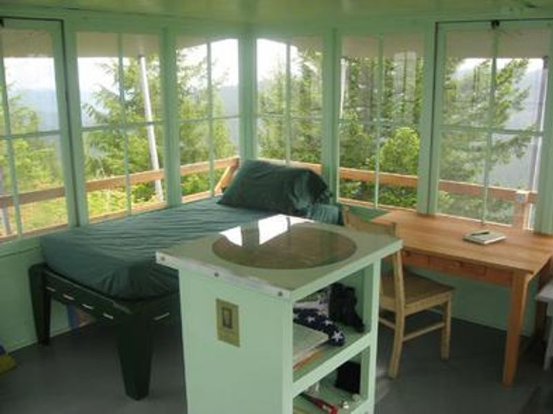
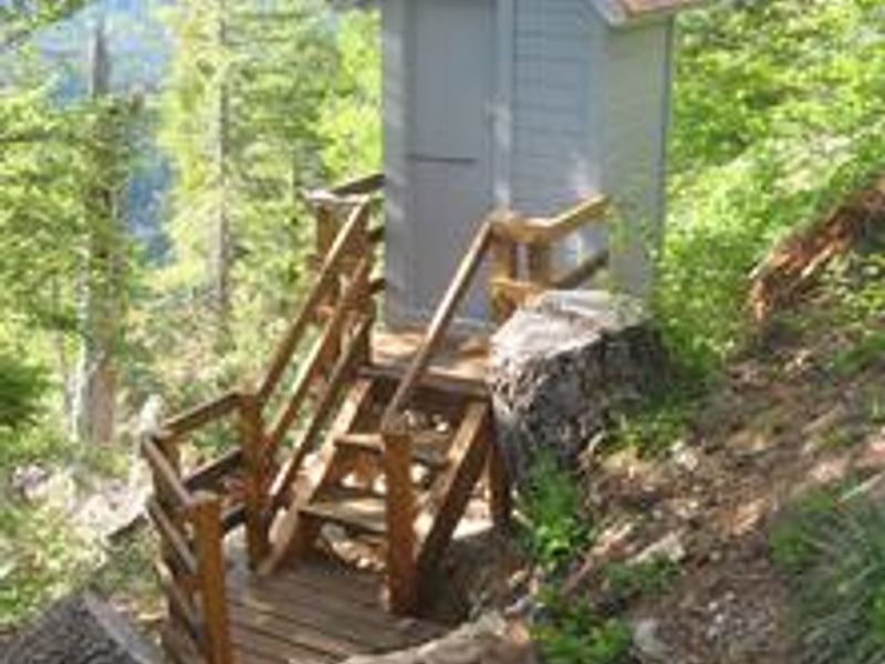
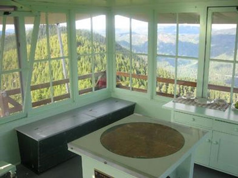
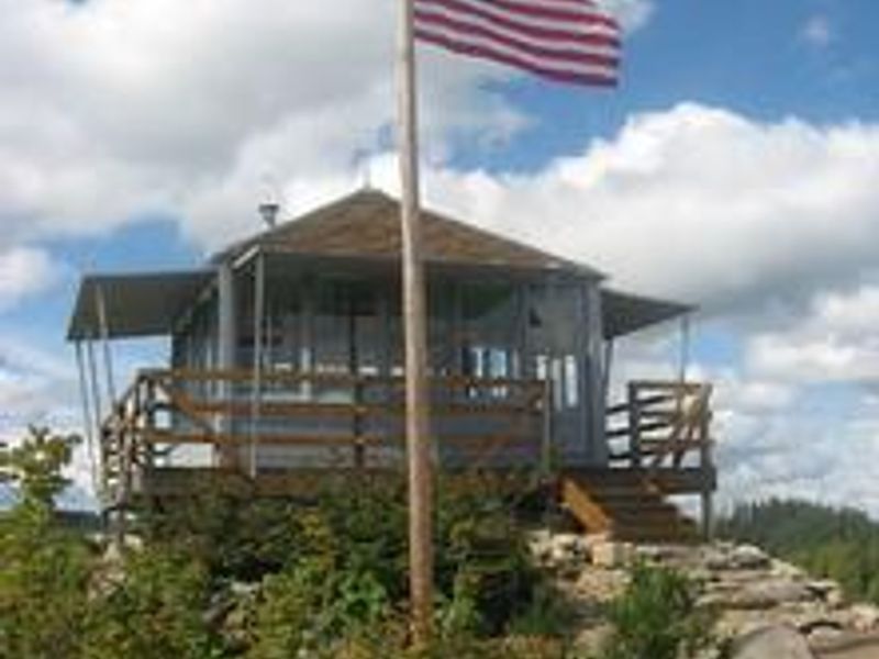
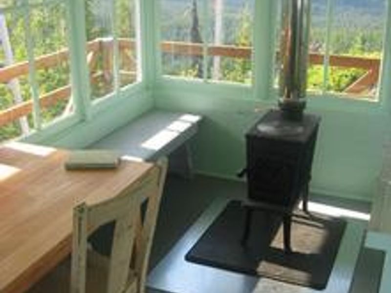
Gold Butte Lookout sits on the summit of Gold Butte at 4,618 feet elevation in Willamette National Forest, offering one of Oregon's most spectacular panoramic viewpoints. Built in 1934 by the Civilian Conservation Corps, this historic structure served as an Aircraft Warning System station during World War II, staffed around the clock by husband-and-wife teams reporting all passing aircraft to central command. The 14x14-foot wood cabin stands on 3-foot stilts and is surrounded by glass windows with an exterior catwalk providing unobstructed 360-degree views of the Cascade Range, including Mt. Jefferson, Three Fingered Jack, Mt. Hood, and the Three Sisters. The cabin is furnished with refurbished period furniture including one twin bed with mattress, three folding cots, table, bench, chair, cabinet, and fire-finder stand. A wood stove provides heat, and a propane cookstove is available (bring your own bottled propane). Guests must be prepared for a primitive experience: no water, electricity, or refrigeration. The final half-mile from the parking area requires hiking on steep, difficult terrain. A high-clearance vehicle is recommended for the rough gravel access road. Seasonal wildflowers and wild huckleberries grow nearby, and the adjacent Bull of the Woods, Opal Creek, and Mt. Jefferson Wilderness areas offer excellent day hiking opportunities.
Directions
From Detroit Ranger Station, drive east on Highway 22 toward Detroit. Directly after crossing the bridge, turn left onto Forest Service Road 46 (Breitenbush). Drive FSR 46 for about 4 miles to FSR 4696. Turn left (northeast) onto FSR 4696 and drive about three-quarters of a mile to FSR 4697. Turn left (north) onto FSR 4697 and drive about 5 miles to the saddle. Turn right onto FSR 451 and proceed to the first right (FSR 453). Proceed through the gate approximately half a mile to the parking area at the second green gate. The last 2 miles are rough gravel and dirt at 10% grade; low-clearance vehicles not recommended. The lookout is approximately half a mile from the parking area via a steep trail to the summit.
Amenities
| Water | No |
| Fires Allowed | — |
| Toilets | Yes |
| Dump Station | No |
| Wifi | No |
| Pets Allowed | Yes |
| Showers | No |
| Electric Hookups | — |
| Water Hookups | — |
| Sewer Hookups | — |
| Camp Store | No |
| Price | $80 |
Vehicle
| Max RV Length | — |
| Max Trailer Length | — |
| Big Rig Friendly | No |
| Pull Through Sites | No |
Contact
| Phone | +1 (503) 854-3366 |
Cell Service
| AT&T | None |
| Verizon | None |
| T-Mobile | None |
Availability
Photos
Community Posts
No posts yet. Be the first to share your experience!