Farley Canyon Primitive Camping
Open for camping. Vault toilets are seasonal; when unavailable, campers must bring portable toilets. The nearby Hite area is closed. The Shoreline Access Area past the camping zone is closed to vehicles. $12/night, first-come first-served, no reservations.
Flash Flood Warning issued July 20 at 8:45PM MDT until July 20 at 11:45PM MDT by NWS Grand Junction CO
FFWGJT The National Weather Service in Grand Junction has issued a * Flash Flood Warning for... The Deer Creek burn scar in... Western Montrose County in west central Colorado... Northeastern San Juan County in southeastern Utah... * Until 1145 PM MDT. * At 845 PM MDT, Doppler radar indicated thunderstorms producing heavy rain near the Deer Creek Burn Scar. Between 0.5 and 1 inch of rain has fallen. Flash flooding is ongoing or expected to begin shortly. Excessive rainfall over the burn scar will result in debris flows. The debris flow can consist of rock, mud, vegetation and other loose materials. HAZARD...Life threatening flash flooding. Thunderstorms producing flash flooding in and around the Deer Creek Burn Scar. SOURCE...Radar. IMPACT...Life threatening flash flooding of areas in and around the Deer Creek Burn Scar. * Some locations that will experience flash flooding include... mainly rural areas of Western Montrose and Northeastern San Juan Counties This includes the following streams and drainages... Ice Lake Creek, La Sal Creek, and West Paradox Creek.
Flood Watch issued July 20 at 12:15PM MDT until July 22 at 3:00AM MDT by NWS Salt Lake City UT
* WHAT...Flash flooding caused by excessive rainfall is possible. * WHERE...A portion of Utah, including the following areas, Castle Country, Central Mountains, Eastern Juab/Millard Counties, San Rafael Swell, Sanpete Valley, Sevier Valley, Wasatch Plateau/Book Cliffs, Western Millard and Juab Counties, Bryce Canyon Country, Capitol Reef National Park and Vicinity, Glen Canyon Recreation Area/Lake Powell, South Central Utah, Southern Mountains, Upper Sevier River Valleys, Western Canyonlands, Lower Washington County, Southwest Utah and Zion National Park. This includes recent burn scars such as Cottonwood, Silver King, Forsyth, France Canyon, Monroe Canyon. * WHEN...From Tuesday afternoon through late Tuesday night. * IMPACTS...Excessive rainfall may result in flooding of slot canyons, normally dry washes, slick rock areas, recent burn scars including Forsyth, France Canyon, Cottonwood, Silver King, and Monroe Canyon, and other low-lying and flood-prone locations. Flooding may occur in poor drainage and urban areas. * ADDITIONAL DETAILS... - http://www.weather.gov/safety/flood
Hydrologic Outlook issued July 20 at 10:32AM MDT by NWS Grand Junction CO
ESFGJT Anomalous moisture has become established across portions of eastern Utah and western Colorado. Scattered thunderstorms capable of producing heavy rain are expected this afternoon and early evening. Rainfall rates of 1-2 inches per hour will be possible with the stronger storms. These rates could lead to flash flooding and debris flows especially over steep terrain and recent burn scars. Also, rain over the past several days has lead to saturated soils, which increase the chances for excessive runoff. As a reminder: Keep an eye on our forecasts through the end of the week and stay tuned for updated hydrology alerts if visiting or if you reside below vulnerable terrain to flash flooding and/or debris flows. Storms across the west develop quickly, leaving little room for lead time in flashy terrain.
About
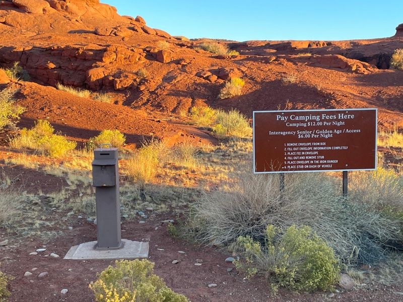
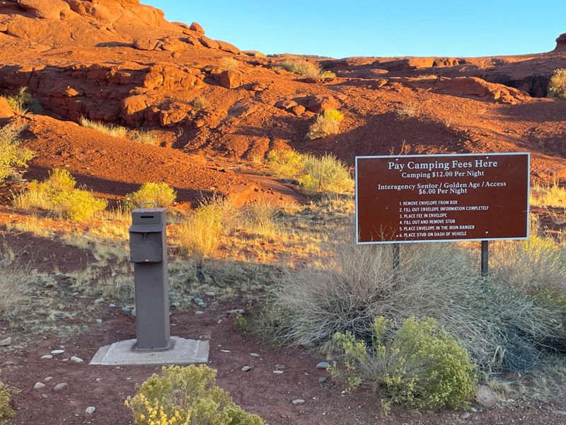
Farley Canyon Primitive Camping Area sits within Glen Canyon National Recreation Area, offering a rugged camping experience near Lake Powell. The area is reached via Highway 95 south of Hanksville, turning west at the signed Farley Canyon Access road and traveling approximately two miles to the camping zone. The road conditions vary with weather, so check conditions before traveling. The nearby Hite area is currently closed to the public. This is dispersed primitive camping with no designated sites, no hookups, and minimal amenities. Vault toilets are available seasonally; when they are not operational, campers must bring approved portable toilet systems and properly dispose of waste in the sewer system. There is no potable water, so bring adequate supplies. Campfires are permitted in NPS-provided fire receptacles and along Lake Powell's shoreline below the 3,700-foot high-water level, except in developed areas. Camping costs $12 per night on a first-come, first-served basis with no reservations. Pay cash at the iron ranger at the road's end, or pay by card online. Quiet hours are 10pm to 6am. Camping is limited to 14 consecutive nights and 30 nights total per calendar year. The Farley Canyon Shoreline Access Area beyond the camping zone is currently closed to all vehicles.
Directions
From Hanksville, UT, drive south on Highway 95 for approximately 53 miles. At the brown sign indicating Farley Canyon Access, turn west. The road continues about two miles to the camping area. Check weather before traveling to ensure road conditions are suitable for your vehicle.
Nearby Campgrounds
Amenities
| Water | No |
| Fires Allowed | Yes |
| Toilets | Yes |
| Dump Station | No |
| Wifi | No |
| Pets Allowed | Yes |
| Showers | No |
| Electric Hookups | — |
| Water Hookups | — |
| Sewer Hookups | — |
| Camp Store | No |
| Price | $12 |
Vehicle
| Max RV Length | — |
| Max Trailer Length | — |
| Big Rig Friendly | No |
| Pull Through Sites | — |
Contact
| glca_information@nps.gov | |
| Phone | +1 (928) 608-6200 |
Cell Service
| AT&T | None |
| Verizon | None |
| T-Mobile | None |
Photos
Community Posts
No posts yet. Be the first to share your experience!