View of Mount Hood from Stone Creek Campground's day use area

Stone Creek Campground

Open

Open from Friday of Memorial Day weekend through the second full weekend of September. Reservations available via Recreation.gov. Check-in is 4 PM; check-out is 12 PM.

Alcohol Prohibitions

This Order describes acts that are prohibited upon lands, roads and trails within the National Forest System administered by the Forest Service Pacific Northwest Region in regards to alcoholic beverages.

Aquatic Invasive Species

This Order prohibits 1) possessing, storing, or transporting any aquatic invasive animal species AND 2) prohibits possessing, storing, or transporting any aquatic or riparian invasive plant species - on National Forest System lands in the Pacific Northwest Region as specified in the Order.

Restrictions on Use of Forage and Mulch Products

This Order prohibits unloading, storing, or using any straw, hay, grain, seed, or other forage or mulch products that are not state-certified weed free on the National Forest System lands, roads or trails in any Closure Area as specific in the Order. Some examples of these include hay bales, hay…

Fireworks and Explosives are always Prohibited

Fireworks and explosives (including explosive targets) are always prohibited on national forest lands. The prohibition of fireworks and exploding targets on national forest system lands is part of a set of permanent fire safety regulations in the Code of Federal Regulations (CFR), listed below.…

FR 4613 road damage- use caution

Following December storms, the North Clackamas Bridge on FR 4613 suffered severe scour and a large hole created on the approach to the south side of the bridge. A large steel plate has been installed to maintain temporary safe passage.  A less significant scour on the northern approach to the same…

Erosion hazards on Pioneer Bridle Trail

Caution: Pioneer Bridle Trail has heavy damage in multiple sections due to erosion from winter storms. Deep ruts could be dangerous for mountain bikers and other users. Bikers should be prepared to dismount for stretches. Trails staff have flagged and signed a particularly dangerous section of…

Hazards from Winter Storms

Heavy rains and strong winds created many hazards across Mt. Hood National Forest and surrounding areas during December storms. Although the storms have passed, conditions across the Forest may still be unsafe. Multiple trails and recreation sites across the Clackamas River, Hood River, and Zigzag…

Eagle Creek Fire Area Closures

In 2017, the Eagle Creek Fire caused extensive damage to surrounding areas in Columbia River Gorge and parts of Mt. Hood National Forest. Some trails are closed to the public in both the Gorge and Hood River Ranger District, pursuant to 16 USC § 551 and 36 CFR 261.50 (a) and (b). This closure is…

Health and Safety Closure Due to Roadside Danger Trees

This Order prohibits using any type of motor vehicle upon the following NFS Roads as described: 1) NFS Road 45 (Memaloose Road) from the bridge at highway 224 to the junction with NFS Road 45-310 and 2) NFS Road 54 from the highway 224 junction (at the bridge gate) to NFS Road 5410.

Bull Run Watershed Closure

This Order prohibits 1) Going into or being upon the area which is closed for the protection of public health or safety, 2) Being on a road, 3) Being on a trail within the area described in Exhibit A, except to travel on the Pacific Crest National Scenic Trail #2000 and Huckleberry Trail #617, and…

Camping Stay Restrictions

This Order prohibits 1) Camping in a single location for a period longer than 14 consecutive days and 2) Camping at any location for more than 28 days total during a calendar year on all National Forest System lands as described in this order.

Crane Creek bridge closed on the Barlow Road

The Crane Creek bridge on the Barlow Road (Forest Road 3530) is collapsed and closed. The Barlow Road is open, but it can't be driven from end to end.Crane Creek bridge​Located approximately 0.4 miles east of the Forest Road 4885-Barlow Road junction.There are temporary barricades and signage…

Sportsman's Park Fire & Occupancy Restrictions

This Forest Order prohibits 1) Building, maintaining, attending or using a fire, campfire, or stove fire and 2) Camping on the Mt. Hood National Forest, Barlow Ranger District; T4S, R11E, Multiple Sections - Sportsman's Park Wildland Urban Interface Zone.

Gordon Creek Watershed Restrictions

This Order prohibits 1) Using a motor vehicle on Forest development roads, except Forest Road 15, which is also known as Larch Mt Road, 2) Using a motor vehicle on Forest development trails, 3) Possessing or using a motor vehicle off Forest development roads, and 4) Camping within the Gordon Creek…

The Dalles Watershed Closure

This Order prohibits visitors from entering or being on the roads or trails of The Dalles Watershed.

About

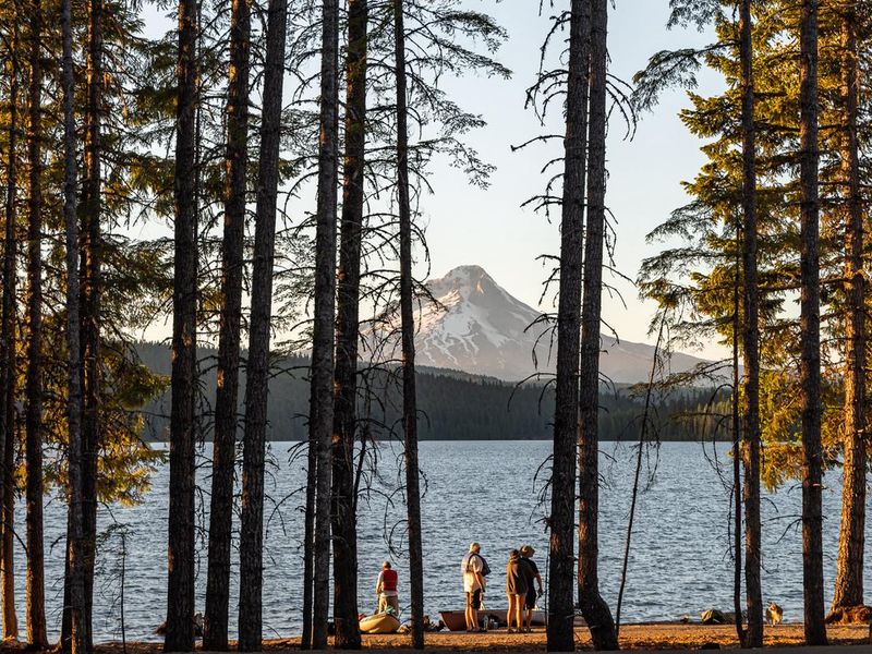
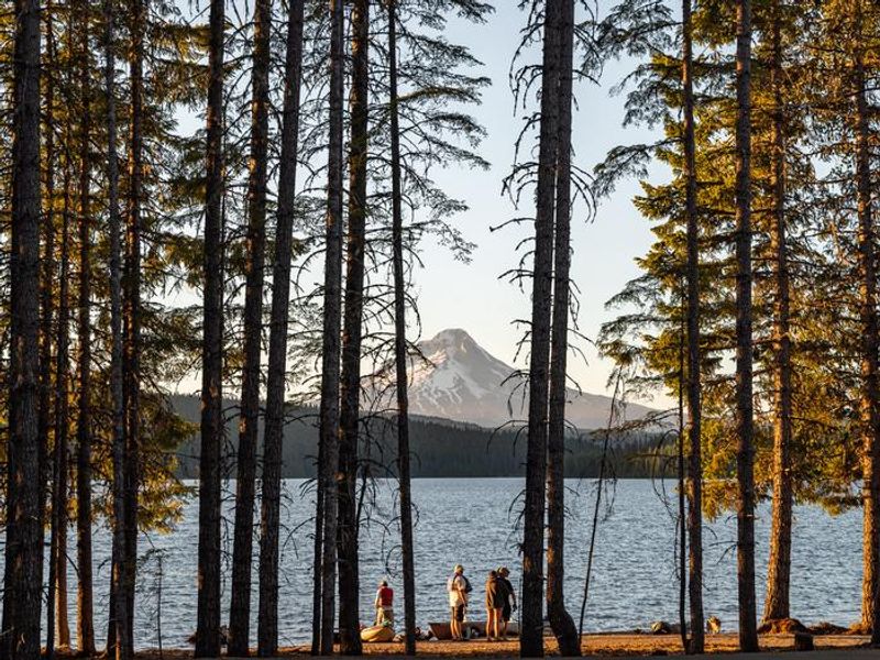
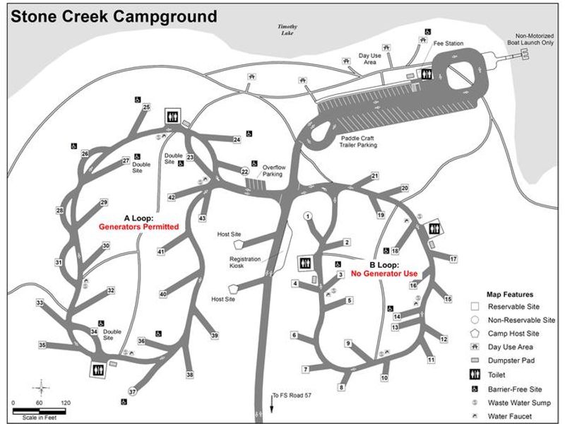
Stone Creek Campground occupies a forested cove on Timothy Lake's southeastern shore within Mount Hood National Forest. Created in 1956 as a storage reservoir for the Oak Grove Hydroelectric Project, Timothy Lake spans roughly 1,400 acres and offers excellent fishing for kokanee salmon and various trout species. The campground sits at 3,400 feet elevation in a mixed conifer forest with a thick rhododendron understory providing privacy between sites. The campground is divided into separate loops: Loop B contains 21 tent-only sites where generators are prohibited, while Loop A offers 22 RV-sized non-electric sites. Two equestrian-friendly group camps accommodating 36 people each are located across the road. A day-use area provides non-motorized boat access, picnicking, and views of Mt. Hood. The 12-mile Timothy Lake Trail circles the lake and connects to the Pacific Crest National Scenic Trail. The Clackamas Lake Ranger Station Historic District, featuring early 1900s rustic architecture, lies less than 3 miles away. Timberline Lodge on Mt. Hood is approximately 28 miles north.

Directions

From Sandy, Oregon, travel east on Highway 26 for approximately 40 miles to Skyline Road/Road 42. Turn right on Skyline Road and continue south for about 9 miles. Turn right on Forest Service Road 57 and travel west for 3 miles, then turn right at the Stone Creek Campground entrance sign.

Amenities

Water Yes
Fires Allowed Yes
Toilets Yes
Dump Station
Wifi No
Pets Allowed Yes
Showers No
Electric Hookups
Water Hookups
Sewer Hookups
Camp Store
Price $28 - $56

Vehicle

Max RV Length 50ft
Max Trailer Length 50ft
Big Rig Friendly
Pull Through Sites No

Contact

Email pgeparks@pgn.com
Phone +1 (503) 464-8515

Cell Service

AT&T Yes
Verizon Yes
T-Mobile None

Availability

Photos

View of Mount Hood from Stone Creek Campground's day use area
View of Mount Hood from Stone Creek Campground shoreline
Stone Creek Campground - Draft Plans
Stone Creek Campground Map

Community Posts

No posts yet. Be the first to share your experience!