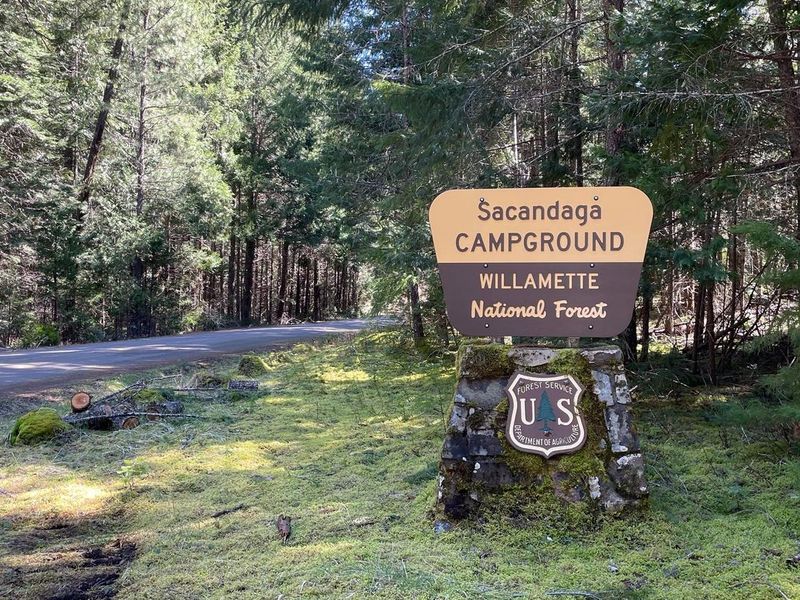
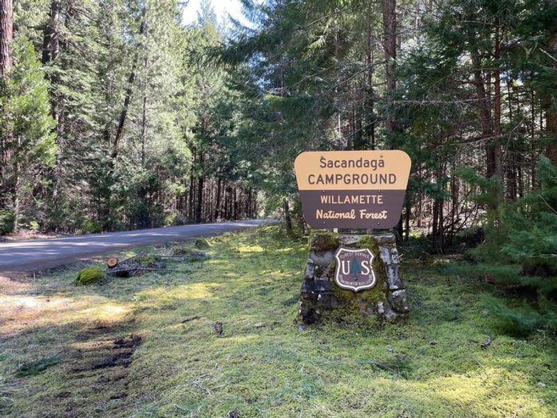
The Middle Fork flows nearby the campground, with trails in the campground leading to the banks of the river.
Open

Open for the 2026 season from May 16 through October 31. First-come, first-served sites available; 7 of 17 sites are reservable via Recreation.gov with 5-day advance booking required. The area was impacted by the Emigrant Fire; Forest Road 21 may have delays and post-fire hazards exist including increased risk of landslides and debris flows.

Alcohol Prohibitions

This Order describes acts that are prohibited upon lands, roads and trails within the National Forest System administered by the Forest Service Pacific Northwest Region in regards to alcoholic beverages.

Aquatic Invasive Species

This Order prohibits 1) possessing, storing, or transporting any aquatic invasive animal species AND 2) prohibits possessing, storing, or transporting any aquatic or riparian invasive plant species - on National Forest System lands in the Pacific Northwest Region as specified in the Order.

Restrictions on Use of Forage and Mulch Products

This Order prohibits unloading, storing, or using any straw, hay, grain, seed, or other forage or mulch products that are not state-certified weed free on the National Forest System lands, roads or trails in any Closure Area as specific in the Order. Some examples of these include hay bales, hay…

Fireworks and Explosives are always Prohibited

Fireworks and explosives (including explosive targets) are always prohibited on national forest lands. The prohibition of fireworks and exploding targets on national forest system lands is part of a set of permanent fire safety regulations in the Code of Federal Regulations (CFR), listed below.…

Detroit Ranger Station closed June 12

The Detroit Ranger Station will be closed on Friday, June 12 for building maintenance. All other ranger stations and offices will be open.

Delays on Forest Service Road 21 (Diamond Drive)

Contractors are completing road reconstruction on Forest Service Road (FSR) 21, also known as Diamond Drive, from mid-June through July on the Middle Fork Ranger District. Crews will be filling pot holes and patching the surface of the road for the entire length of FSR 21, starting near Oakridge…

Forest Service Road 2643 (Foley Ridge Road) Closure Order

Forest Service Road (FSR) 2643, also known as Foley Ridge Road, will be closed to all vehicle, bike, and foot traffic from May 26 through June 30 for road maintenance. Crews will be resurfacing the road, starting near Highway 126 from milepost 0.0 thru milepost 4.6. The project is weather…

Beachie Creek and Lionshead Fires Closure

The Willamette National Forest has issued a closure order to restrict visitors from being on specific roads, trails, or developed recreation sites as listed in the Forest Order. The closed areas were impacted by the Beachie Creek and Lionshead Fires.

Cedar Creek Fire Closure

To provide for public safety, a closure order is in place for the following areas impacted by the Cedar Creek Fire.

Terwilliger Hot Springs Nudity, Alcohol, and Closed Times

The following is prohibited: to park or possess an alcoholic beverage in restricted areas, be publicly nude visible from Forest Road 19, and to enter or use Terwilliger Hot Springs between 10 p.m. and sunrise.

Emigrant Fire Closure Order

Pursuant to 16 USC 551 and 36 CFR § 261.50 (a) and (b), and to provide for public safety, the following acts are prohibited in the areas described in this Order on National Forest System lands within the administrative boundaries of the Willamette National Forest. This Order…

Tamolitch Parking / Trail Construction Closure

Tamolitch Parking and Trail Construction Closure Forest Order.Forest roads 2600-735, 2600-738, and 2600-739: and the area is described as beginning at the junction of Highway 126 and 2600-735 road, west along the 2600-735 road, then northwest to the highwater mark of the east bank of the McKenzie…

Detroit Dispersed Camping Restrictions

Pursuant to 16 USC§ 551 and 36 CFR 261.50(a) and (b), and to provide for public safety, the following acts are prohibited in the Closure Areas, roads and their associated spur roads, trailheads, and recreation sites described in this order on National Forest System lands within the administrative…

FIRE CLOSURES: Current wildfire closures on the Willamette National Forest

For updates on active fires, visit our fire Incident Information page. Fire Closures:Cedar Creek Fire Closure Order & Map (updated 3/23/26)Beachie Creek and Lionshead Fires Closure Order & Map (updated 05/21/26)Map of All Fire Closures in Pacific Northwest

14 Day Stay Camping Limit

Camping, occupying, or otherwise leaving camping equipment and/or related supplies at any locations on the Willamette National Forest described in this order, overnight, for a period longer than 14 calendar days, in a 30-day period.

Camping Restrictions in Cougar Recreation Area

The Cougar Recreation Area is a specially designated area around Cougar Reservoir. It includes a 1/2-mile strip on either side of Forest Service Road 19 from Hwy 126 to Forest Service Road 1927 as well as Terwilliger Hot Springs, Hidden Lake Day Use Area, areas surrounding Delta Campground, Slide…

Moose and Gordon Dispersed Camping Closure

The purpose of this closure is to prohibit dispersed overnight camping and make these areas available as day-use only. This is to allow river access for all users, reduce conflict, reduce safety concerns, reduce and eliminate health and sanitation issues associated with improper disposal of human…

Special Wilderness Permit, Camping and Fire Restrictions

This outlines special restrictions on the Willamette and Deschutes National Forests.

Occupation Use Restriction in Middle Fork Ranger District

The following acts are prohibited in the areas described in this order within the administrative boundaries of the Willamette National Forest.Prohibitions:1. Being in the area after sundown to before sunrise.2. Parking in violation of posted instructions.

About

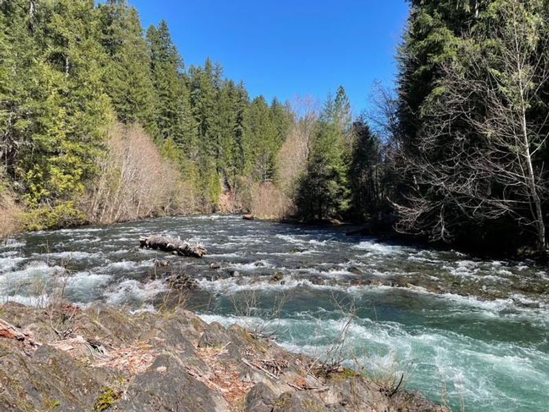
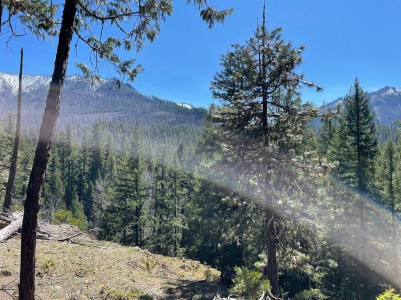
Situated 27 miles southeast of Oakridge, Oregon, Sacandaga Campground occupies a forested terrace above the Middle Fork of the Willamette River. Towering old-growth Douglas fir and pine trees surround the 17 campsites, creating a peaceful atmosphere even during busy summer weekends. The campground serves as a basecamp for exploring the Middle Fork Ranger District's diverse recreation opportunities. Two short trails within the campground provide direct access to the Middle Fork River for fishing and wading. The nearby Middle Fork National Recreation Trail offers extended adventures for hikers, mountain bikers, and equestrians. Other popular destinations include Young's Rock, Chuckle Springs, Indigo Springs, and the Diamond Peak Wilderness. The campground provides vault toilets, potable water from a hand pump, picnic tables at each site, and regular trash service. Campfires are permitted in designated fire rings when seasonal restrictions allow. The area was impacted by the Emigrant Fire and visitors should be aware of potential post-fire hazards including increased risk of debris flows during heavy rain.

Directions

From Oakridge, Oregon: From the junction of Crestview Street and Highway 58 (the only traffic light in Oakridge), proceed east on Highway 58 for 1.7 miles. Turn right onto Hills Creek Road/Kitson Springs Road. Travel 0.5 miles and turn right onto Forest Road 21. Follow Forest Road 21 for 24.6 miles; the campground entrance will be on your right.

Amenities

Water Yes
Fires Allowed Yes
Toilets Yes
Dump Station No
Wifi No
Pets Allowed Yes
Showers No
Electric Hookups
Water Hookups
Sewer Hookups
Camp Store No
Price $6

Vehicle

Max RV Length
Max Trailer Length
Big Rig Friendly
Pull Through Sites No

Contact

Phone +1 (541) 782-2283

Cell Service

AT&T None
Verizon None
T-Mobile None

Availability

Photos

The Middle Fork flows nearby the campground, with trails in the campground leading to the banks of the river.
The entrance sign to the campground can be easily seen from Forest Service Road 21 and leads directly to the campground.
Another trail within the campground leads to a view of nearby peaks and offers wonderful birdwatching.
The entrance sign to the campground can be easily seen from Forest Service Road 21 and leads directly to the campground.

Community Posts

No posts yet. Be the first to share your experience!