Campers Flat
Open for the 2026 season (May through October). Reservations required via Recreation.gov. Access code for the locked gate is provided upon reservation or by contacting the Middle Fork Ranger Station during weekday business hours.
Alcohol Prohibitions
This Order describes acts that are prohibited upon lands, roads and trails within the National Forest System administered by the Forest Service Pacific Northwest Region in regards to alcoholic beverages.
Aquatic Invasive Species
This Order prohibits 1) possessing, storing, or transporting any aquatic invasive animal species AND 2) prohibits possessing, storing, or transporting any aquatic or riparian invasive plant species - on National Forest System lands in the Pacific Northwest Region as specified in the Order.
Restrictions on Use of Forage and Mulch Products
This Order prohibits unloading, storing, or using any straw, hay, grain, seed, or other forage or mulch products that are not state-certified weed free on the National Forest System lands, roads or trails in any Closure Area as specific in the Order. Some examples of these include hay bales, hay…
Fireworks and Explosives are always Prohibited
Fireworks and explosives (including explosive targets) are always prohibited on national forest lands. The prohibition of fireworks and exploding targets on national forest system lands is part of a set of permanent fire safety regulations in the Code of Federal Regulations (CFR), listed below.…
Detroit Ranger Station closed June 12
The Detroit Ranger Station will be closed on Friday, June 12 for building maintenance. All other ranger stations and offices will be open.
Delays on Forest Service Road 21 (Diamond Drive)
Contractors are completing road reconstruction on Forest Service Road (FSR) 21, also known as Diamond Drive, from mid-June through July on the Middle Fork Ranger District. Crews will be filling pot holes and patching the surface of the road for the entire length of FSR 21, starting near Oakridge…
Forest Service Road 2643 (Foley Ridge Road) Closure Order
Forest Service Road (FSR) 2643, also known as Foley Ridge Road, will be closed to all vehicle, bike, and foot traffic from May 26 through June 30 for road maintenance. Crews will be resurfacing the road, starting near Highway 126 from milepost 0.0 thru milepost 4.6. The project is weather…
Beachie Creek and Lionshead Fires Closure
The Willamette National Forest has issued a closure order to restrict visitors from being on specific roads, trails, or developed recreation sites as listed in the Forest Order. The closed areas were impacted by the Beachie Creek and Lionshead Fires.
Cedar Creek Fire Closure
To provide for public safety, a closure order is in place for the following areas impacted by the Cedar Creek Fire.
Terwilliger Hot Springs Nudity, Alcohol, and Closed Times
The following is prohibited: to park or possess an alcoholic beverage in restricted areas, be publicly nude visible from Forest Road 19, and to enter or use Terwilliger Hot Springs between 10 p.m. and sunrise.
Emigrant Fire Closure Order
Pursuant to 16 USC 551 and 36 CFR § 261.50 (a) and (b), and to provide for public safety, the following acts are prohibited in the areas described in this Order on National Forest System lands within the administrative boundaries of the Willamette National Forest. This Order…
Tamolitch Parking / Trail Construction Closure
Tamolitch Parking and Trail Construction Closure Forest Order.Forest roads 2600-735, 2600-738, and 2600-739: and the area is described as beginning at the junction of Highway 126 and 2600-735 road, west along the 2600-735 road, then northwest to the highwater mark of the east bank of the McKenzie…
Detroit Dispersed Camping Restrictions
Pursuant to 16 USC§ 551 and 36 CFR 261.50(a) and (b), and to provide for public safety, the following acts are prohibited in the Closure Areas, roads and their associated spur roads, trailheads, and recreation sites described in this order on National Forest System lands within the administrative…
FIRE CLOSURES: Current wildfire closures on the Willamette National Forest
For updates on active fires, visit our fire Incident Information page. Fire Closures:Cedar Creek Fire Closure Order & Map (updated 3/23/26)Beachie Creek and Lionshead Fires Closure Order & Map (updated 05/21/26)Map of All Fire Closures in Pacific Northwest
14 Day Stay Camping Limit
Camping, occupying, or otherwise leaving camping equipment and/or related supplies at any locations on the Willamette National Forest described in this order, overnight, for a period longer than 14 calendar days, in a 30-day period.
Camping Restrictions in Cougar Recreation Area
The Cougar Recreation Area is a specially designated area around Cougar Reservoir. It includes a 1/2-mile strip on either side of Forest Service Road 19 from Hwy 126 to Forest Service Road 1927 as well as Terwilliger Hot Springs, Hidden Lake Day Use Area, areas surrounding Delta Campground, Slide…
Moose and Gordon Dispersed Camping Closure
The purpose of this closure is to prohibit dispersed overnight camping and make these areas available as day-use only. This is to allow river access for all users, reduce conflict, reduce safety concerns, reduce and eliminate health and sanitation issues associated with improper disposal of human…
Special Wilderness Permit, Camping and Fire Restrictions
This outlines special restrictions on the Willamette and Deschutes National Forests.
Occupation Use Restriction in Middle Fork Ranger District
The following acts are prohibited in the areas described in this order within the administrative boundaries of the Willamette National Forest.Prohibitions:1. Being in the area after sundown to before sunrise.2. Parking in violation of posted instructions.
About
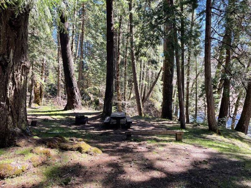
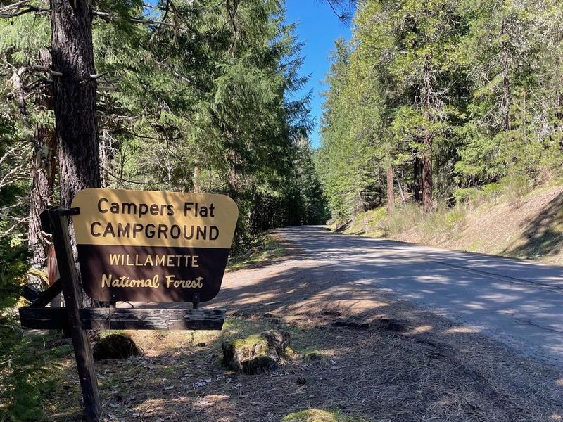
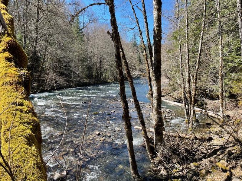
Campers Flat is a reservable group campground located 22 miles south of Oakridge, Oregon along the Middle Fork of the Willamette River in the Willamette National Forest. The single group site sits on an open river terrace beneath a canopy of Douglas-firs, Ponderosa pines, and cedars, offering a peaceful setting where the sound of the river drowns out passing traffic on Forest Road 21. The campground is well-positioned for trail-based recreation. The Middle Fork National Recreation Trail can be accessed directly from camp, and the Young's Rock Trail ends across the road. Both trails accommodate hikers, mountain bikers, and equestrians. Fishing is available in the Middle Fork and nearby Hills Creek Reservoir when in season. Chuckle Springs and Indigo Springs provide additional hiking destinations a short drive away. The site includes vault toilets, potable water from a hand pump, metal fire rings, and picnic tables. Pets and horses are permitted. The campground accommodates up to 30 people, 10 vehicles, and 10 tents, with a maximum vehicle length of 25 feet. A locked gate controls access; the combination is provided upon reservation or by contacting the Middle Fork Ranger Station.
Directions
From Oakridge, Oregon: From the traffic light on Highway 58, proceed east 1.7 miles. Turn right on Hills Creek Road/Kitson Springs Road. Travel 0.5 miles and turn right onto Forest Road 21. Follow FR 21 for 20 miles; the locked gate to the campground will be on your right.
Amenities
| Water | Yes |
| Fires Allowed | Yes |
| Toilets | Yes |
| Dump Station | No |
| Wifi | No |
| Pets Allowed | Yes |
| Showers | No |
| Electric Hookups | — |
| Water Hookups | — |
| Sewer Hookups | — |
| Camp Store | No |
| Price | $50 |
Vehicle
| Max RV Length | 25ft |
| Max Trailer Length | 25ft |
| Big Rig Friendly | No |
| Pull Through Sites | No |
Contact
| Phone | +1 (541) 782-2283 |
Cell Service
| AT&T | None |
| Verizon | None |
| T-Mobile | None |
Availability
Photos
Community Posts
No posts yet. Be the first to share your experience!