USA 250 Shirt →

Lyman Lake Cabins

Open

Open year-round. There is currently no drinking water at the park; campers must bring their own supply. Restrooms and showers are fully functional. Check-in is 3 p.m., check-out is 10 a.m. Reservations available online at azstateparks.com or by calling 1-877-697-2757.

Severe Thunderstorm Warning issued July 20 at 7:25PM MST until July 20 at 8:00PM MST by NWS Flagstaff AZ

7:25 PM — 8:00 PM

SVRFGZ The National Weather Service in Flagstaff has issued a * Severe Thunderstorm Warning for... Apache County in northeastern Arizona... * Until 900 PM MDT. * At 825 PM MDT, severe thunderstorms were located along a line from 7 miles northeast of Nazlini to 6 miles southwest of Oak Springs, or along a line from 16 miles southeast of Chinle to 56 miles southeast of Chinle, moving west at 15 mph. HAZARD...60 mph wind gusts and small hail. SOURCE...Radar indicated. IMPACT...Expect damage to roofs, siding, and trees. * Locations impacted include... Nazlini, Burnside, Klagetoh, Oak Springs, Antelope Lake, Ganado, Kinlichee, Hubbell Trading Post National Historic Site, Pine Springs, Flat Rock, Wood Springs and Choyojdolid. This includes the following highways... State Route 264 between mile markers 443 and 463. Highway 191 between mile markers 397 and 411...and between mile markers 421 and 432.

Flash Flood Warning issued July 20 at 4:42PM MST until July 20 at 7:45PM MST by NWS Flagstaff AZ

4:42 PM — 7:45 PM

FFWFGZ The National Weather Service in Flagstaff has issued a * Flash Flood Warning for... Navajo County in north central Arizona... Apache County in northeastern Arizona... * Until 745 PM MST. * At 442 PM MST, Doppler radar indicated thunderstorms producing heavy rain from Woodruff to Snowflake. Flash flooding is ongoing or expected to begin shortly. HAZARD...Life threatening flash flooding. Thunderstorms producing flash flooding. SOURCE...Radar indicated. IMPACT...Life threatening flash flooding of creeks and streams, normally dry washes, urban areas, highways, streets and underpasses. * Some locations that will experience flash flooding include... Taylor, Shumway, Woodruff, Petrified Forest National Park, Taylor Airport, Rainbow Forest Lodge, Schoens Lake, Snowflake, White Mountain Lake Estates, White Mountain Lake Airport, Crystal Forest and Petrified Forest National Wilderness Area. This includes the following highways... State Route 377 between mile markers 17 and 28. State Route 277 between mile markers 330 and 336. State Route 77 between mile markers 351 and 382. Highway 180 between mile markers 314 and 330. This includes the following creeks, washes and rivers... Phoenix Park Wash, Teds Wash, Concho Flat Wash, Jim Camp Wash, Mexican Hollow Wash, Canal, The, Washboard Wash, Hay Hollow Draw, Show Low Creek, Dodson Wash, Porter Tank Draw, Wild Cow Wash, Puerco River, Scott Wash, Dry Creek, Cottonwood Wash, Sevenmile Draw, Silver Creek, Cheney Draw, Rocky Arroyo, Little Colorado River, Milky Wash, Fivemile Wash, Carr Lake Draw, East Washboard Wash and Little Milky Wash.

Flood Watch issued July 20 at 12:38PM MST until July 21 at 10:00PM MST by NWS Flagstaff AZ

12:38 PM — 8:45 PM

* WHAT...Flash flooding caused by excessive rainfall is possible. * WHERE...Portions of east central, north central, northeast, and west central Arizona, including the following areas, in east central Arizona, Northern Gila County. In north central Arizona, Black Mesa Area, Coconino Plateau, Eastern Mogollon Rim, Grand Canyon Country, Kaibab Plateau, Little Colorado River Valley in Coconino County, Marble and Glen Canyons, Northeast Plateaus and Mesas Hwy 264 Northward, Northeast Plateaus and Mesas South of Hwy 264 and Western Mogollon Rim. In northeast Arizona, Little Colorado River Valley in Apache County, Little Colorado River Valley in Navajo County and White Mountains. In west central Arizona, Yavapai County Mountains. * WHEN...From Tuesday morning through Tuesday evening. * IMPACTS...Flash flooding will be possible in creeks, normally dry washes, swimming holes, and over recently burned areas. Raging killer currents will be possible in side canyons and narrow slot canyons. Low-water crossings may be flooded. * ADDITIONAL DETAILS... - Deep monsoon moisture in place across northern Arizona will lead to storms capable of producing rainfall in excess of 2 inches per hour, resulting in an enhanced risk of flash flooding. - Additional information is available at weather.gov/flagstaff.

About

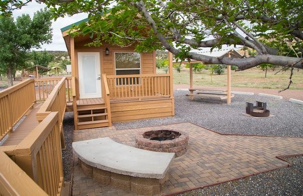
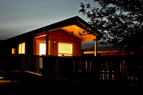
Lyman Lake State Park's camping cabins provide a comfortable base for exploring Arizona's high country. Located 11 miles south of St. Johns on Highway 191, the eight cabins sit at 6,000 feet elevation overlooking a 1,500-acre reservoir fed by snowmelt from Mount Baldy and Escudilla Mountain. Each cabin includes two rooms with bunk-style beds, electricity, heating, air conditioning, and outside water and electric hookups. The cabins share modern facilities including flush restrooms with hot water and showers. Each site has a covered porch, picnic table, and charcoal grill. The on-site camp store stocks ice, groceries, camping and fishing supplies, bait, tackle, firewood, and propane. A dump station is available for $20. The reservoir offers diverse recreation including fishing for walleye, channel catfish, and largemouth bass, along with boating, swimming, and water skiing. The Petroglyph Trail provides access to ancient rock art. Summer temperatures reach the 80s to low 90s, making the lake a welcome respite from lower desert heat.

Directions

Located 11 miles south of St. Johns on Highway 191.

Amenities

Water No
Fires Allowed
Toilets Yes
Dump Station Yes
Wifi
Pets Allowed Yes
Showers Yes
Electric Hookups Yes
Water Hookups Yes
Sewer Hookups No
Camp Store Yes
Price $80

Vehicle

Max RV Length
Max Trailer Length
Big Rig Friendly
Pull Through Sites No

Contact

Phone +1 (928) 337-4441

Cell Service

AT&T None
Verizon Yes
T-Mobile None

Availability

Photos

Community Posts

No posts yet. Be the first to share your experience!