Long Branch State Park Shelters
The shelters are open for day-use reservations. Note that these are picnic shelters for daytime gatherings only, not overnight camping facilities. The park's campground is closed for all of 2026 due to construction.
Tornado Watch issued June 11 at 2:48PM CDT until June 11 at 9:00PM CDT by NWS Kansas City/Pleasant Hill MO
TORNADO WATCH 313 REMAINS VALID UNTIL 9 PM CDT THIS EVENING FOR THE FOLLOWING AREAS IN MISSOURI THIS WATCH INCLUDES 9 COUNTIES IN NORTH CENTRAL MISSOURI GRUNDY LINN LIVINGSTON MACON MERCER PUTNAM SULLIVAN IN NORTHEAST MISSOURI ADAIR SCHUYLER THIS INCLUDES THE CITIES OF BROOKFIELD, CHILLICOTHE, DOWNING, GLENWOOD, GREEN CITY, GREENTOP, KIRKSVILLE, LA PLATA, LANCASTER, MACON, MARCELINE, MERCER, MILAN, PRINCETON, QUEEN CITY, TRENTON, AND UNIONVILLE.
Flood Warning issued June 11 at 2:40PM CDT until June 14 at 5:56PM CDT by NWS Kansas City/Pleasant Hill MO
...The Flood Warning is extended for the following rivers in Missouri... Chariton River near Prairie Hill affecting Macon and Chariton Counties. * WHAT...Major flooding is occurring and major flooding is forecast. * WHERE...Chariton River near Prairie Hill. * WHEN...Until Sunday afternoon. * IMPACTS...At 15.0 feet, Fields along the river begin to flood. At 19.0 feet, Farmland and secondary roads in the Chariton River floodplain are under water. At 20.0 feet, State Highway 129 is overtopped by flood waters 8 miles north of Salisbury. * ADDITIONAL DETAILS... - At 1:45 PM CDT Thursday the stage was 21.5 feet. - Forecast...The river is expected to rise to a crest of 22.2 feet just after midnight tonight. It will then fall below flood stage Saturday afternoon. - Flood stage is 15.0 feet. - Flood History...This crest compares to a previous crest of 22.3 feet on 05/13/2010. - http://www.weather.gov/safety/flood
Flood Warning issued June 11 at 10:40AM CDT until June 11 at 10:30PM CDT by NWS Kansas City/Pleasant Hill MO
* WHAT...Flooding caused by excessive rainfall is expected. * WHERE...Northeastern Chariton County in north central Missouri... Daviess County in north central Missouri... Grundy County in north central Missouri... Harrison County in north central Missouri... Linn County in north central Missouri... Northern Livingston County in north central Missouri... Macon County in north central Missouri... Mercer County in north central Missouri... Putnam County in north central Missouri... Northwestern Randolph County in north central Missouri... Sullivan County in north central Missouri... Adair County in northeastern Missouri... Schuyler County in northeastern Missouri... Northeastern DeKalb County in northwestern Missouri... Gentry County in northwestern Missouri... Worth County in northwestern Missouri... * WHEN...Until 1030 PM CDT Thursday. * IMPACTS...Numerous roads remain closed due to flooding. * ADDITIONAL DETAILS... - At 1036 AM CDT, Transportation department officials indicate numerous closed roads due to high water as a result of recent heavy rainfall. Flooding is already occurring. Between 2 and 7 inches of rain have fallen over the past 24 hours. - Additional rainfall amounts of 0.5 to 1.5 inches are possible in the warned area later today. This flood warning replaces the previous warning which expires at 1045 am. - Some locations that will experience flooding include... Kirksville, Trenton, Macon, Brookfield, Bethany, Marceline, Milan, Unionville, Albany, La Plata, Lancaster, Princeton, Grant City, Bevier, Green City, Queen City, Jamesport, Bucklin and Ridgeway. - http://www.weather.gov/safety/flood
About
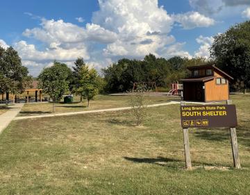
Long Branch State Park's picnic shelters provide covered gathering spaces on the shores of Long Branch Lake in Macon County, Missouri. Two shelters are available for day-use reservation, each capable of hosting groups of up to 60 people. Both shelters feature electrical hookups for serving equipment, multiple picnic tables, and outdoor charcoal grills for cooking. The South Shelter includes accessibility accommodations and sits adjacent to a playground, making it particularly suitable for family gatherings. Restroom facilities are located nearby. When not reserved, shelters are available on a first-come, first-served basis at no charge. Note: These are day-use picnic facilities, not overnight camping sites. The park's campground is closed for all of 2026 due to construction. For overnight stays, contact the park office for information about alternative options.
Directions
Located at 28615 Visitor Center Road, Macon, MO 63552. The park is situated along Long Branch Lake in Macon County.
Nearby Campgrounds
Amenities
| Water | Yes |
| Fires Allowed | Yes |
| Toilets | Yes |
| Dump Station | No |
| Wifi | — |
| Pets Allowed | Yes |
| Showers | No |
| Electric Hookups | — |
| Water Hookups | — |
| Sewer Hookups | — |
| Camp Store | Yes |
| Price | $40 |
Vehicle
| Max RV Length | — |
| Max Trailer Length | — |
| Big Rig Friendly | — |
| Pull Through Sites | No |
Contact
| Phone | +1 (660) 773-5229 |
Cell Service
| AT&T | None |
| Verizon | Yes |
| T-Mobile | Yes |
Availability
Photos
Community Posts
No posts yet. Be the first to share your experience!