Arid Peak Lookout
Closed for the season. The lookout typically opens in late June when trail conditions allow access and remains open through late September. Reservations available via Recreation.gov up to 6 months in advance.
Air Quality Alert issued July 20 at 12:33PM PDT by NWS Spokane WA
An Air Quality Alert has been cancelled by the following agencies: Idaho Department of Environmental Quality in Coeur d'Alene Coeur d'Alene Tribe Idaho Department of Environmental Quality in Lewiston Nez Perce Tribe
Air Quality Alert issued July 20 at 12:33PM PDT by NWS Spokane WA
An Air Quality Alert has been cancelled by the following agencies: Idaho Department of Environmental Quality in Coeur d'Alene Coeur d'Alene Tribe Idaho Department of Environmental Quality in Lewiston Nez Perce Tribe
Air Quality Alert issued July 20 at 10:43AM PDT by NWS Spokane WA
An Air Quality Alert has been issued by the following agencies: Idaho Department of Environmental Quality in Coeur d'Alene Coeur d'Alene Tribe Environmental Protection Agency * WHAT...Air Quality Advisory due to wildfire smoke. Air Quality Index is forecasted to be Unhealthy for Sensitive Groups. For the latest air quality readings, head to https://fire.airnow.gov or visit the Idaho Smoke Blog at www.idsmoke.blogspot.com. * WHERE...Boundary County, Bonner, Kootenai, Shoshone, Benewah Counties. * WHEN...Next update by 12 PM Monday, July 20th. * IMPACTS...Some members of the public may experience health effects; members of sensitive groups may experience more serious health effects.
About
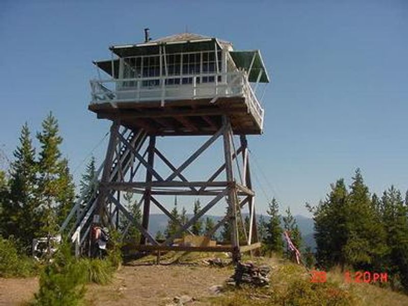
Arid Peak Lookout was built in 1934 to detect fires sparked by the Milwaukee Railroad Line. After sitting idle for over 25 years following its last staffing in 1969, a team of over 30 volunteers, the Forest Fire Lookout Association, and the U.S. Forest Service restored it to its original splendor in 1997. The lookout is listed on the National Register of Historic Lookouts. The 20-foot tower sits at an elevation of 5,306 feet within a mixed conifer forest of Douglas fir and spruce. Wildlife sightings of elk, deer, black bears, moose, and bald eagles are common. The cabin accommodates up to four guests with two cots and mattresses, basic cooking gear, dishes, a propane lantern, propane camp stove, water containers, a table with two chairs, a wood stove, and one rodent-proof food container. Guests must bring their own propane canisters (16.4 oz), bedding, food, water, toilet paper, and warm clothing. The nearby Hiawatha Bicycle Trail, considered the crown jewel of rail-to-trail mountain biking, is accessible about 10 miles from the lookout. The area offers access to Arid Peak Trail #173, Mozier Peak Trail #174, and Kyle Creek Trail #175 for day hiking, backpacking, or horseback riding.
Directions
From Avery, head north on North Fork St. Joe River Road #456 toward Wallace. Travel about 4.5 miles, then turn left down the hill just before the bridge across the river onto Road #1997, a single lane gravel road with pullouts. Drive about 3.5 miles and turn left on the first road (also labeled Road #1997). Travel 6.5 miles to Trailhead #175. Park in the wide spot by the trailhead. Hike up Trail #175 for 1.5 miles to the junction with Trail #173, then turn right and hike 1.5 miles on Trail #173 to Arid Peak.
Amenities
| Water | No |
| Fires Allowed | — |
| Toilets | Yes |
| Dump Station | No |
| Wifi | No |
| Pets Allowed | No |
| Showers | No |
| Electric Hookups | — |
| Water Hookups | — |
| Sewer Hookups | — |
| Camp Store | No |
| Price | $45 |
Vehicle
| Max RV Length | — |
| Max Trailer Length | — |
| Big Rig Friendly | No |
| Pull Through Sites | No |
Contact
| Phone | +1 (208) 245-2531 |
Cell Service
| AT&T | None |
| Verizon | None |
| T-Mobile | None |
Availability
Photos
Community Posts
No posts yet. Be the first to share your experience!