Wakonda Lake Campground
Open year-round. Showers and potable water are available April 15 through October 31 only. Two-night minimum stay required on weekends. Limited to 15 days within any 30-consecutive-day period.
Flood Warning issued June 11 at 11:52AM CDT until June 15 at 3:31AM CDT by NWS St Louis MO
...The Flood Warning continues for the following rivers in Missouri... South Fabius River near Taylor. North Fabius River near Ewing. Mid Fork Salt River near Holliday. ...The Flood Warning is extended for the following rivers in Missouri... North River at Palmyra. Middle Fabius River near Ewing. River forecasts are based on observed precipitation and forecast precipitation for the next 24 hours. * WHAT...Minor flooding is occurring and moderate flooding is forecast. * WHERE...Middle Fabius River near Ewing. * WHEN...Until late Sunday night. * IMPACTS...At 19.2 feet, Lewis County Road Monterey Street near Lemon Street will begin flooding near this height. * ADDITIONAL DETAILS... - At 11:30 AM CDT Thursday the stage was 16.5 feet. - Recent Activity...The maximum river stage in the 24 hours ending at 11:30 AM CDT Thursday was 16.5 feet. - Forecast...The river is expected to rise to a crest of 19.1 feet early tomorrow afternoon. It will then fall below flood stage late Saturday evening. - Flood stage is 12.0 feet.
Flood Warning issued June 11 at 11:52AM CDT until June 15 at 5:48AM CDT by NWS St Louis MO
...The Flood Warning continues for the following rivers in Missouri... South Fabius River near Taylor. North Fabius River near Ewing. Mid Fork Salt River near Holliday. ...The Flood Warning is extended for the following rivers in Missouri... North River at Palmyra. Middle Fabius River near Ewing. River forecasts are based on observed precipitation and forecast precipitation for the next 24 hours. * WHAT...Minor flooding is occurring and moderate flooding is forecast. * WHERE...North Fabius River near Ewing. * WHEN...Until late Sunday night. * IMPACTS...At 17.1 feet, Right bank begins flooding at the gage. * ADDITIONAL DETAILS... - At 11:30 AM CDT Thursday the stage was 13.5 feet. - Recent Activity...The maximum river stage in the 24 hours ending at 11:30 AM CDT Thursday was 13.5 feet. - Forecast...The river is expected to rise to a crest of 17.0 feet tomorrow morning. It will then fall below flood stage late Saturday evening. - Flood stage is 11.0 feet.
Flood Watch issued June 11 at 11:50AM CDT until June 11 at 7:00PM CDT by NWS St Louis MO
* WHAT...Flash flooding caused by excessive rainfall is possible. * WHERE...Portions of west central Illinois, including the following areas, Adams IL and Brown IL and northeast Missouri, including the following areas, Knox MO, Lewis MO, Marion MO and Shelby MO. * WHEN...Until 7 PM CDT this evening. * IMPACTS...Excessive runoff may result in flooding of rivers, creeks, streams, and other low-lying and flood-prone locations. Area creeks and streams are running high and additional heavy rain rates could cause new flooding, or worsen ongoing flooding. * ADDITIONAL DETAILS... - A brief round of thunderstorms with heavy rain rates is expected later this afternoon and evening, and while this round will only last 1 to 3 hours, these areas have already seen considerable recent rains and area creeks and streams are already swollen. As such, additional Flash Flooding will be possible late this afternoon and evening.
About
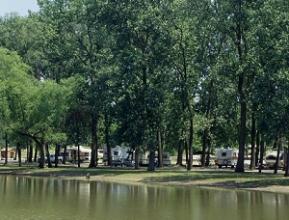
Wakonda Lake Campground sits along the wooded shoreline of Wakonda Lake within Wakonda State Park, located south of La Grange in Lewis County. The campground features sewer/electric/water hookup sites and operates year-round, though showers and potable water are only available during the on-season from April 15 through October 31. A dump station, laundry facilities, vault toilets, and a playground are available on-site. The park encompasses six clear-water lakes that attract thousands of migratory waterfowl annually, making it a destination for bird watchers. Fishing opportunities include largemouth bass, bluegill, crappie, and catfish. Two boat ramps provide lake access, though boats are restricted to idle speed only. Agate and Jasper lakes close to boating November 1 through January 31 and February 15 through March 31 for annual waterfowl migrations. Reservations can be made up to 12 months in advance through icampmo.com or by calling 877-ICampMO. A two-night minimum stay is required on weekends, and camping is limited to 15 days within any 30-consecutive-day period.
Directions
Located 3 miles south of La Grange on U.S. Highway 61. Address: 32836 State Park Road, La Grange, MO 63448.
Amenities
| Water | Yes |
| Fires Allowed | — |
| Toilets | Yes |
| Dump Station | Yes |
| Wifi | — |
| Pets Allowed | Yes |
| Showers | Yes |
| Electric Hookups | Yes |
| Water Hookups | Yes |
| Sewer Hookups | Yes |
| Camp Store | — |
| Price | $35 |
Vehicle
| Max RV Length | 110ft |
| Max Trailer Length | — |
| Big Rig Friendly | — |
| Pull Through Sites | No |
Contact
| moparks@dnr.mo.gov | |
| Phone | +1 (573) 655-2280 |
Cell Service
| AT&T | Yes |
| Verizon | Yes |
| T-Mobile | Yes |
Availability
Photos
Community Posts
No posts yet. Be the first to share your experience!