Lumsden Bridge Campground
Currently closed due to storm damage on Lumsden Road. The road closure is indefinite pending repairs. When accessible, the campground typically operates May through September. Lumsden Road is also seasonally closed December 15 through April 15.
National Forest System Roads
Follow California Vehicle Code on National Forest System Roads
Fireworks and Explosives are always Prohibited
Fireworks and explosives (including explosive targets) are always prohibited on national forest lands. The prohibition of fireworks and exploding targets on national forest system lands is part of a set of permanent fire safety regulations in the Code of Federal Regulations (CFR), listed below.…
Temporary Moderate Hazard Fire Restrictions Stanislaus National Forest
Temporary Moderate Hazard Fire Restrictions Stanislaus National Forest
About
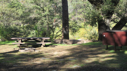
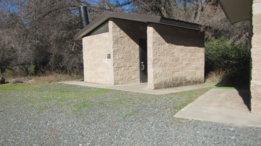
Lumsden Bridge Campground occupies a scenic low-elevation setting on the Tuolumne Wild & Scenic River within Stanislaus National Forest. The campground sits in a pine and oak forest approximately one mile from South Fork Campground and two miles from Lumsden Campground, forming part of the Tuolumne-Lumsden Recreation Area known for whitewater rafting and kayaking. Each campsite includes a picnic table and campfire pit with grill. A vault toilet serves the campground, but there is no potable water; untreated river water is available when flowing and must be filtered or treated before drinking. The campground operates on a first-come, first-served basis with no reservations available. Access via Lumsden Road involves a steep, narrow, and winding route that is not suitable for RVs or trailers. The road is seasonally closed December 15 through April 15 and may close during inclement weather. The campground lies within the Rim Fire burned area, where hazards include falling rocks, flash floods, debris flows, and weakened trees that may fall without warning.
Directions
From Groveland, travel approximately 7.5 miles east on Highway 120 to Ferretti Road. Turn left (north) onto Ferretti Road. Travel 1 mile and turn right (east) onto Lumsden Road/Forest Route 1N01. Continue approximately 6.5 miles to Lumsden Bridge. The campground entrance is on the north side of the bridge; turn left (west) after crossing the bridge to enter.
Location
Amenities
| Water | No |
| Fires Allowed | Yes |
| Toilets | Yes |
| Dump Station | No |
| Wifi | No |
| Pets Allowed | — |
| Showers | No |
| Electric Hookups | — |
| Water Hookups | — |
| Sewer Hookups | — |
| Camp Store | No |
| Price | $25 |
Vehicle
| Max RV Length | — |
| Max Trailer Length | — |
| Big Rig Friendly | No |
| Pull Through Sites | — |
Contact
| Phone | +1 (209) 532-3671 |
Cell Service
| AT&T | None |
| Verizon | None |
| T-Mobile | None |
Photos


Community Posts
No posts yet. Be the first to share your experience!