Irons Mountain Hiker-biker Campsite
Open year-round, free, first-come, first-served. No reservations required. Stays limited to one night per site. Non-potable well water is available mid-April through mid-November; water is turned off during winter months for freeze protection.
Severe Thunderstorm Watch issued July 21 at 2:47PM EDT until July 21 at 10:00PM EDT by NWS Baltimore MD/Washington DC
THE NATIONAL WEATHER SERVICE HAS ISSUED SEVERE THUNDERSTORM WATCH 509 IN EFFECT UNTIL 10 PM EDT THIS EVENING FOR THE FOLLOWING AREAS THE DISTRICT OF COLUMBIA IN MARYLAND THIS WATCH INCLUDES 16 COUNTIES IN CENTRAL MARYLAND ANNE ARUNDEL HOWARD MONTGOMERY PRINCE GEORGES IN NORTH CENTRAL MARYLAND CARROLL FREDERICK WASHINGTON IN NORTHEAST MARYLAND CECIL IN NORTHERN MARYLAND BALTIMORE BALTIMORE CITY HARFORD IN SOUTHERN MARYLAND CALVERT CHARLES ST. MARYS IN WESTERN MARYLAND ALLEGANY GARRETT IN VIRGINIA THIS WATCH INCLUDES 34 COUNTIES IN CENTRAL VIRGINIA ALBEMARLE CITY OF CHARLOTTESVILLE CITY OF FREDERICKSBURG GREENE KING GEORGE NELSON ORANGE SPOTSYLVANIA IN NORTHERN VIRGINIA ARLINGTON CITY OF ALEXANDRIA CITY OF FAIRFAX CITY OF FALLS CHURCH CITY OF MANASSAS CITY OF MANASSAS PARK CULPEPER FAIRFAX FAUQUIER LOUDOUN PRINCE WILLIAM STAFFORD IN NORTHWEST VIRGINIA CITY OF WINCHESTER CLARKE FREDERICK MADISON PAGE RAPPAHANNOCK SHENANDOAH WARREN IN WESTERN VIRGINIA AUGUSTA CITY OF HARRISONBURG CITY OF STAUNTON CITY OF WAYNESBORO HIGHLAND ROCKINGHAM IN WEST VIRGINIA THIS WATCH INCLUDES 8 COUNTIES IN EASTERN WEST VIRGINIA GRANT HAMPSHIRE HARDY MINERAL PENDLETON IN PANHANDLE WEST VIRGINIA BERKELEY JEFFERSON MORGAN THIS INCLUDES THE CITIES OF ABERDEEN, ABINGDON, ADAMS MORGAN, ADEN, AIRLIE, ALBIN, ALEXANDRIA, ALONZAVILLE, ALSOP, ANDORA, ANNANDALE, ANNAPOLIS, ANTIOCH, APPLETON, ARCO, ARKENDALE, ARLINGTON, ARNOLD, BAKERTON, BALLENGER CREEK, BALLSTON, BALTIMORE, BARCROFT, BARKSDALE, BAY VIEW, BEAN SETTLEMENT, BENTONVILLE, BERKELEY SPGS, BERRYVILLE, BERRYVILLE, BETHEL, BETHESDA, BLAKE, BLOOMERY, BOHEMIAS MILLS, BOWIE, BOYDS, BRADY, BRAKE, BRANDYWINE, BRANTWOOD, BROKENBURG, BROOKFIELD, BROOMES ISLAND, BUCKEYSTOWN, BUCKTON, BURKE, BURR HILL, BYNUM, CABINS, CALIFORNIA, CALLAWAY, CARDOVA, CATALPA, CATONSVILLE, CEDAR GROVE, CEDARVILLE, CHANTILLY, CHARLES TOWN, CHARLOTTESVILLE, CHERRYDALE, CHESAPEAKE BEACH, CHESTER GAP, CHRISTIAN, CHURCHVILLE, CLARKSVILLE, CLARY, CLINTON, CLOVER CREEK, COLLEGE PARK, COLUMBIA, COMPTON, COUNTRYSIDE, COVE POINT, CULPEPER, CUMBERLAND, DAHLGREN, DALE CITY, DAMERON, DRUM POINT, DULLES INTERNATIONAL AIRPORT, DUNDALK, DUNKIRK, EDGEWOOD, ELDERSBURG, ELLERSLIE, ESSEX, EVERONA, FAIRFAX, FAIRFAX STATION, FAIRVIEW, FALLS CHURCH, FALMOUTH, FELLS POINT, FISHER, FIVE FORKS, FORDSVILLE, FORT ASHBY, FOUR CORNERS, FRANKLIN, FREDERICK, FREDERICKSBURG, FRENCHBURG, FRONT ROYAL, FROSTBURG, GAINESBORO, GAITHERSBURG, GAMBER, GARRISONVILLE, GATEWOOD, GERMANTOWN, GLEEDSVILLE, GLEN BURNIE, GLEN ECHO, GLENDIE, GLENMONT, GRANTSVILLE, GREENBELT, GREENFIELD, HAGERSTOWN, HALFWAY, HAMBURG, HANCOCK, HARFORD FURNACE, HARRISONBURG, HAWKINSTOWN, HEADSVILLE, HICKORY, HIGHTOWN, HISTORIC ELLICOTT CITY, HOWELLSVILLE, INDEPENDENT HILL, KEYSER, KIMBALL, KLINE GAP, LAHORE, LAKE RIDGE, LANDES, LANGLEY, LEESBURG, LEXINGTON PARK, LIBERTY, LINVILLE, LONG BEACH, LUCKETTS, LURAY, MADISON MILLS, MADISON RUN, MAGNOLIA, MAGNOLIA, MANASSAS, MANASSAS PARK, MARTINSBURG, MASONVILLE, MASSAPONAX, MCCOOLE, MCDOWELL, MCLEAN, MCNEILL, MIDDLEWAY, MILL GAP, MILLVILLE, MONTCLAIR, MONTEBELLO, MONTEREY, MONTPELIER, MOOREFIELD, MOUNT CLIFTON, MOUNT HARMONY, MOUNT JACKSON, MOUNTAIN LAKE PARK, MUSTOE, NASONS, NEW CREEK, OAK FLAT, OAK GROVE, OAKLAND, ORANGE, OVERTON, PARK HEIGHTS, PARK MILLS, PARKVILLE, PARTLOW, PAW PAW, PETERSBURG, PINEY POINT, POINTS, POST OAK, PURGITSVILLE, RANDALLSTOWN, RANSON, RAPIDAN, RAWLINGS, REAGAN NATIONAL AIRPORT, RESTON, REVA, RIDGE, RIDGEVILLE, RIDGEWAY, RILEYVILLE, RIVERCREST, RIVERTON, ROLLINS FORK, ROMNEY, ROSSLYN, RUDDLE, RUSSELLDALE, SEVERN, SEVERNA PARK, SEYMOURVILLE, SHADY GROVE, SHADY GROVE, SHENANDOAH JUNCTION, SHILOH, SILVER SPRING, SIMPSONVILLE, SKYLAND, SMITH CROSSROADS, SOTTERLEY, SOUTH GATE, SPOTSYLVANIA COURT, SPOTTSWOOD, SPRINGFIELD, ST. CHARLES, STAUNTON, STERLING PARK, STEVENSBURG, STRASBURG, STRINGTOWN, STUARTS DRAFT, SUGAR GROVE, SUITLAND-SILVER HILL, TANTALLON, THREE CHURCHES, TOWSON, TURNBULL, TWYMANS MILL, UNIONVILLE, WALDORF, WAPOCOMO, WARRENTON, WASHINGTON, WAYNESBORO, WELTON, WESTMINSTER, WIDEWATER, WINCHESTER, WINSTON, WOODBRIDGE, WOODLAWN, WOODSTOCK, AND WOODSTOCK.
About
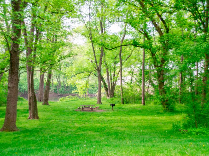
Irons Mountain Hiker-Biker Campsite sits at Mile 175.3 along the historic C&O Canal towpath, one of roughly 30 primitive campsites spaced every 5-7 miles along the 184.5-mile trail. This free, first-come, first-served site requires no reservation and limits stays to one night per trip, making it ideal for through-hikers and cyclists traversing the towpath. The campsite includes a chemical toilet, picnic table, fire ring, and non-potable well water. Water must be filtered, chemically treated, or boiled before drinking or cooking. Well handles are removed from mid-November to mid-April for freeze protection, so plan to pack in all water during winter months. Fires are permitted only in the provided fire rings or in portable grills positioned off the ground. Coals must be fully extinguished and packed out. Firewood collection is limited to dead material on the ground. This is a trash-free park, so all garbage must be packed out. Pets are welcome but must remain leashed. Quiet hours are 10 PM to 6 AM.
Directions
Located at mile 175.3 on the C&O Canal towpath. Accessible only by foot, bicycle, or horseback via the towpath.
Nearby Campgrounds
Amenities
| Water | No |
| Fires Allowed | Yes |
| Toilets | Yes |
| Dump Station | No |
| Wifi | No |
| Pets Allowed | Yes |
| Showers | No |
| Electric Hookups | — |
| Water Hookups | — |
| Sewer Hookups | — |
| Camp Store | No |
| Price | $0 |
Vehicle
| Max RV Length | — |
| Max Trailer Length | — |
| Big Rig Friendly | No |
| Pull Through Sites | No |
Contact
| choh_information@nps.gov | |
| Phone | +1 (301) 739-4200 |
Cell Service
| AT&T | Yes |
| Verizon | None |
| T-Mobile | Yes |
Photos

Community Posts
No posts yet. Be the first to share your experience!