Gauley Tailwaters
Open year-round on a first-come, first-served basis. No reservations, no camping fee. The campground temporarily closes annually in September during peak Gauley Season to allow for additional parking and river access.
Flood Watch issued July 21 at 7:38PM EDT until July 22 at 2:00AM EDT by NWS Charleston WV
* WHAT...Flash flooding caused by excessive rainfall continues to be possible. * WHERE...Portions of northeast Kentucky, including the following counties, Boyd, Carter, Greenup and Lawrence, southeast Ohio, including the following counties, Athens, Gallia, Jackson OH, Lawrence OH, Meigs, Morgan, Vinton and Washington, southwest Virginia, including the following counties, Buchanan and Dickenson, and West Virginia, including the following counties, Barbour, Boone, Braxton, Cabell, Calhoun, Clay, Doddridge, Gilmer, Harrison, Jackson WV, Kanawha, Lewis, Lincoln, Logan, Mason, McDowell, Mingo, Northwest Fayette, Northwest Nicholas, Northwest Pocahontas, Northwest Raleigh, Northwest Randolph, Northwest Webster, Pleasants, Putnam, Ritchie, Roane, Southeast Fayette, Southeast Nicholas, Southeast Raleigh, Southeast Randolph, Southeast Webster, Taylor, Tyler, Upshur, Wayne, Wirt, Wood and Wyoming. * WHEN...Until 2 AM EDT Wednesday. * IMPACTS...Excessive runoff may result in flooding of rivers, creeks, streams, and other low-lying and flood-prone locations. Flooding may occur in poor drainage and urban areas. Low-water crossings may be flooded. Storm drains and ditches may become clogged with debris. * ADDITIONAL DETAILS... - Heavy rainfall from thunderstorms may result in flash flooding. Some storms will be capable of producing 2 to 3 inches of rain in as little as an hour. - http://www.weather.gov/safety/flood
Severe Thunderstorm Watch issued July 21 at 7:30PM EDT until July 21 at 11:00PM EDT by NWS Charleston WV
SEVERE THUNDERSTORM WATCH 506, PREVIOUSLY IN EFFECT UNTIL 8 PM EDT THIS EVENING, IS NOW IN EFFECT UNTIL 11 PM EDT THIS EVENING FOR THE FOLLOWING AREAS IN KENTUCKY THIS WATCH INCLUDES 1 COUNTY IN NORTHEAST KENTUCKY LAWRENCE IN WEST VIRGINIA THIS WATCH INCLUDES 22 COUNTIES IN CENTRAL WEST VIRGINIA BRAXTON CALHOUN CLAY GILMER NICHOLAS ROANE TAYLOR WEBSTER IN NORTHERN WEST VIRGINIA BARBOUR DODDRIDGE HARRISON LEWIS POCAHONTAS RANDOLPH UPSHUR IN SOUTHERN WEST VIRGINIA BOONE FAYETTE KANAWHA LINCOLN PUTNAM IN WESTERN WEST VIRGINIA CABELL WAYNE THIS INCLUDES THE CITIES OF ALUM CREEK, BELINGTON, BRIDGEPORT, BUCKHANNON, BURNSVILLE, CEREDO, CHARLESTON, CLARKSBURG, CLAY, COWEN, CRAIGSVILLE, ELKINS, FAYETTEVILLE, GASSAWAY, GLENVILLE, GRAFTON, GRANTSVILLE, HAMLIN, HARTS, HOLLY RIVER STATE PARK, HUNTINGTON, HURRICANE, KENOVA, LOUISA, MADISON, MARLINTON, OAK HILL, PHILIPPI, RICHWOOD, SAINT ALBANS, SOUTH CHARLESTON, SPENCER, SUMMERSVILLE, SUTTON, TEAYS VALLEY, WAYNE, WEBSTER SPRINGS, WEST UNION, WESTON, AND YATESVILLE LAKE STATE PARK.
Low water conditions on Tuesday and Wednesday September 19-20
Water levels on the Gauley River will be lowered on Tuesday, September 19 and potentially extending into Wednesday, September 20 making rafting or kayaking difficult if not impossible.
About
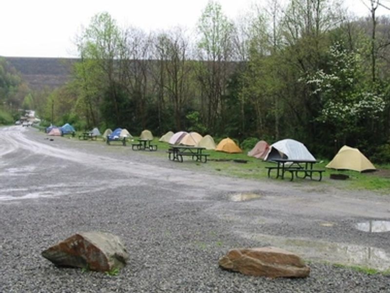
Gauley Tailwaters Campground sits at the base of Summersville Dam where the Gauley River begins its renowned whitewater run through the Gauley River National Recreation Area. Established when the park was created in 1988, this rustic campground serves as the hub for rafters and kayakers, particularly during Gauley Season in fall when controlled dam releases create Class V and VI rapids that draw paddlers from around the world. The campground offers 18 primitive drive-in sites suitable for tents and small RVs or trailers under 25 feet. Sites are first-come, first-served with no reservations and no camping fee. Facilities are minimal: vault toilets and trash collection are provided, but campers must bring their own drinking water as none is available on site. Open fires are permitted only in provided fire receptacles. Quiet hours run from 10 PM to 6 PM, with a 14-night stay limit within any 28-day period. The flat campground is easily accessible with a ramp at the restroom. Sites are close together on grass with a loose gravel parking area. Pets must be kept on leash. From Route 19 at Mt. Nebo, take Route 129 west across the dam, turn left at the river access sign, and bear right through the parking lot to reach the campsites.
Directions
From Route 19 at Mt. Nebo, take Route 129 west across Summersville Dam, then turn left at the river access sign. Bear right through the parking lot to the campsites.
Nearby Campgrounds
Amenities
| Water | No |
| Fires Allowed | Yes |
| Toilets | Yes |
| Dump Station | No |
| Wifi | — |
| Pets Allowed | Yes |
| Showers | No |
| Electric Hookups | — |
| Water Hookups | — |
| Sewer Hookups | — |
| Camp Store | — |
| Price | $0 |
Vehicle
| Max RV Length | 25ft |
| Max Trailer Length | 25ft |
| Big Rig Friendly | No |
| Pull Through Sites | — |
Contact
| neri_interpretation@nps.gov | |
| Phone | +1 (304) 465-0508 |
Cell Service
| AT&T | None |
| Verizon | Yes |
| T-Mobile | None |
Photos

Community Posts
No posts yet. Be the first to share your experience!