Elk Creek Landing
Open for camping. Reservations available via Recreation.gov. Check-in at 6 pm, check-out at 3 pm. Camping limited to 14 consecutive days within any 30-day period.
Flood Advisory issued June 13 at 8:14PM CDT until June 15 at 1:00AM CDT by NWS Tulsa OK
...The Flood Advisory is extended for the following rivers in Oklahoma... Illinois River near Tahlequah affecting Cherokee County. Flint Creek near Kansas affecting Delaware and Cherokee Counties. * WHAT...Flooding caused by excessive rainfall continues. * WHERE...Flint Creek near Kansas. * WHEN...From this evening to early Monday morning. * IMPACTS...At 8.0 feet, Flint Creek threatens individual campsites and becomes dangerous for recreational floating. * ADDITIONAL DETAILS... - At 7:30 PM CDT Saturday the stage was 6.6 feet. - Forecast...The river is expected to rise to a crest of 8.0 feet tomorrow morning, which is at action stage but below flood stage. This forecast is based on forecast rainfall. - Action stage is 8.0 feet. - Flood stage is 11.0 feet. - http://www.weather.gov/safety/flood
Flood Advisory issued June 13 at 8:14PM CDT until June 16 at 7:00PM CDT by NWS Tulsa OK
...The Flood Advisory is extended for the following rivers in Oklahoma... Illinois River near Tahlequah affecting Cherokee County. Flint Creek near Kansas affecting Delaware and Cherokee Counties. * WHAT...Flooding caused by excessive rainfall continues. * WHERE...Illinois River near Tahlequah. * WHEN...From this evening to Tuesday evening. * IMPACTS...At 9.0 feet, no flooding occurs but all recreational floating along the Illinois River ceases at and above 9.5 feet. * ADDITIONAL DETAILS... - At 7:30 PM CDT Saturday the stage was 7.5 feet. - Forecast...The river is expected to rise to a crest of 9.1 feet early Tuesday morning, which is above action stage but below flood stage. This forecast is based on forecast rainfall. - Action stage is 9.0 feet. - Flood stage is 11.0 feet. - http://www.weather.gov/safety/flood
Tornado Watch issued June 13 at 6:24PM CDT until June 13 at 11:00PM CDT by NWS Tulsa OK
THE NATIONAL WEATHER SERVICE HAS ISSUED TORNADO WATCH 330 IN EFFECT UNTIL 11 PM CDT THIS EVENING FOR THE FOLLOWING AREAS IN ARKANSAS THIS WATCH INCLUDES 4 COUNTIES IN NORTHWEST ARKANSAS BENTON CARROLL MADISON WASHINGTON AR IN OKLAHOMA THIS WATCH INCLUDES 13 COUNTIES IN EAST CENTRAL OKLAHOMA CHEROKEE IN NORTHEAST OKLAHOMA ADAIR CRAIG DELAWARE MAYES NOWATA OSAGE OTTAWA PAWNEE ROGERS TULSA WAGONER WASHINGTON OK THIS INCLUDES THE CITIES OF BARTLESVILLE, BENTONVILLE, BERRYVILLE, CLAREMORE, EUREKA SPRINGS, FAYETTEVILLE, GROVE, HUNTSVILLE, JAY, MIAMI, NOWATA, PAWHUSKA, PAWNEE, PRYOR, ROGERS, SPRINGDALE, STILWELL, TAHLEQUAH, TULSA, VINITA, AND WAGONER.
Flood Watch issued June 13 at 11:28AM CDT until June 14 at 1:00PM CDT by NWS Tulsa OK
* WHAT...Flash flooding caused by excessive rainfall continues to be possible. * WHERE...Portions of northwest Arkansas, including the following counties, Benton, Carroll, Madison and Washington AR and Oklahoma, including the following counties, Adair, Cherokee, Craig, Delaware, Mayes, Nowata, Ottawa, Rogers, Wagoner and Washington OK. * WHEN...From 7 PM CDT this evening through Sunday afternoon. * IMPACTS...Excessive runoff may result in flooding of rivers, creeks, streams, and other low-lying and flood-prone locations. * ADDITIONAL DETAILS... - Widespread heavy rainfall amounts of 1 to 3 inches with locally higher amounts of 4 to 5 inches are possible within the watch area. - http://www.weather.gov/safety/flood
About
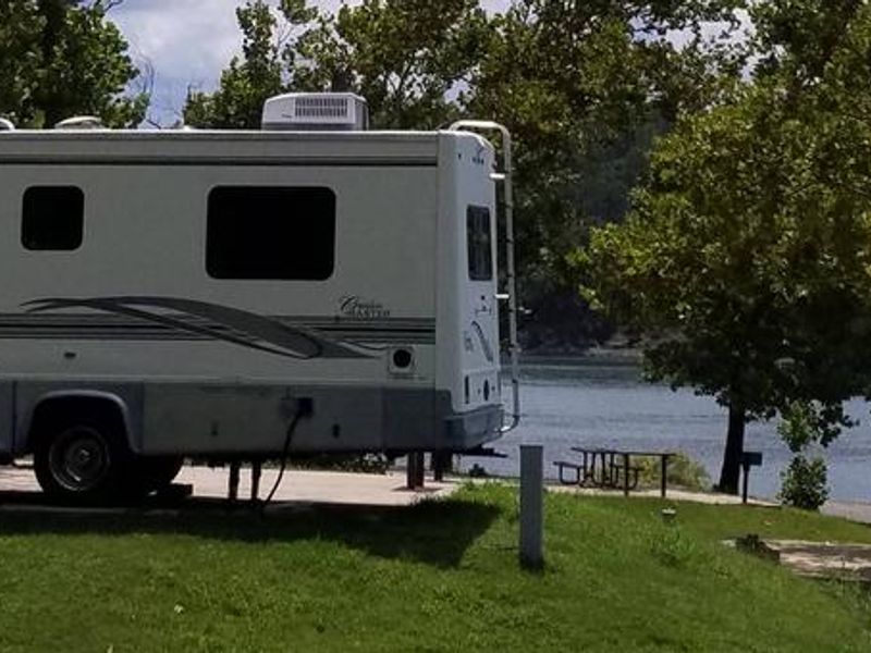
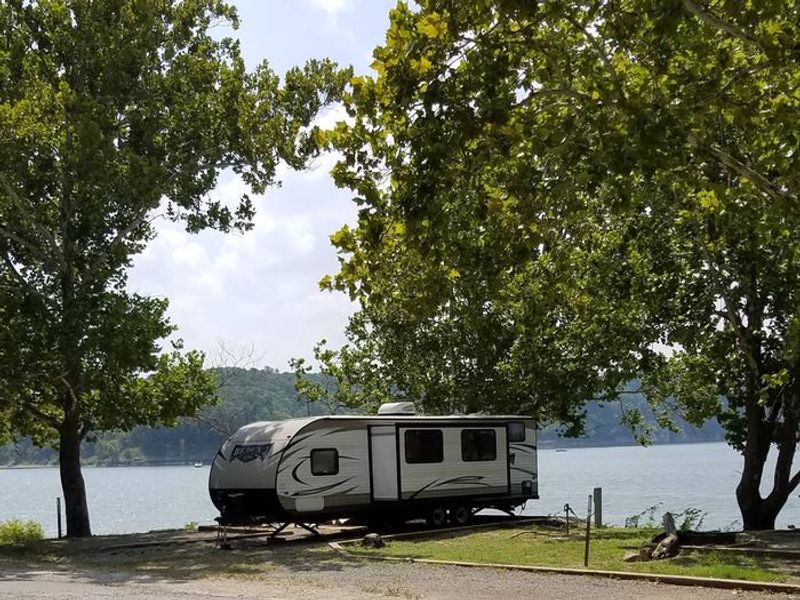
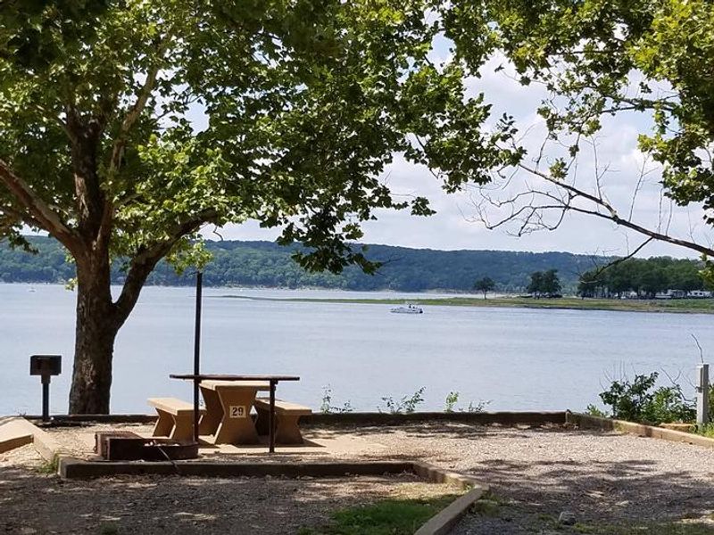
Elk Creek Landing sits on the northeastern tip of Tenkiller Ferry Lake, often called "Oklahoma's clear water paradise." The 12,500-acre lake is fed by the Illinois River and Baron Fork, both designated Oklahoma Scenic Rivers, and is nestled in the Ozark foothills surrounded by dense oak-hickory forests and rolling hills. The campground offers approximately 40 sites, with about half equipped with 30-amp electric hookups. Facilities include a comfort station with flush toilets and hot showers, water hydrants throughout, a dump station, and fire rings at sites. An on-site boat ramp provides direct lake access, and a marina with concessions is nearby. Fishing is excellent for black bass, white bass, striped bass, crappie, and catfish. The tailwater below the dam supports one of only two year-round trout fisheries in Oklahoma. The lake's 130 miles of shoreline and clear waters attract scuba divers, sailors, and water skiers. Wildlife includes deer, turkey, and migratory birds such as bald eagles and white pelicans.
Directions
From Tahlequah, OK, go 14 miles southeast on Highway 82, then turn right and go 1 mile on the paved access road.
Amenities
| Water | Yes |
| Fires Allowed | Yes |
| Toilets | Yes |
| Dump Station | Yes |
| Wifi | — |
| Pets Allowed | Yes |
| Showers | Yes |
| Electric Hookups | Yes |
| Water Hookups | No |
| Sewer Hookups | No |
| Camp Store | Yes |
| Price | $10 - $23 |
Vehicle
| Max RV Length | 84ft |
| Max Trailer Length | 84ft |
| Big Rig Friendly | — |
| Pull Through Sites | No |
Contact
| Phone | +1 (918) 487-5252 |
Cell Service
| AT&T | Yes |
| Verizon | Yes |
| T-Mobile | Yes |
Availability
Photos
Community Posts
No posts yet. Be the first to share your experience!