Bend Guard Station
Open year-round with reservations required via Recreation.gov, except for one week in May reserved for administrative use. Maximum stay is 5 nights per reservation. Check-in at 2:00 PM, checkout at 11:00 AM.
Northern Region Camping & Target Restrictions, Pallet Prohibition
This order defines the maximum length of occupation at a single location or cumulatively at any number of locations within a calendar year, within the states of Montana, North Dakota, South Dakota, and Idaho
Weed Free Forage & Mulch Products Order for the Northern Region
It is illegal to possess, store or transport straw, hay, grain, seed or other forage or mulch products on Forest Service lands without documentation that the product is certified as “weed free” by a state certification process that meets or exceeds the North American Weed Free Forage standards.
R1-2023-02 - NCDE Food and Wildlife Attractant Storage Order
Northern Continental Divide Ecosystem Food/Wildlife Attractant Storage Order for the Flathead, Lolo, Kootenai, Helena-Lewis and Clark, and Beaverhead-Deerlodge National Forests within the Northern Continental Divide Ecosystem.
About
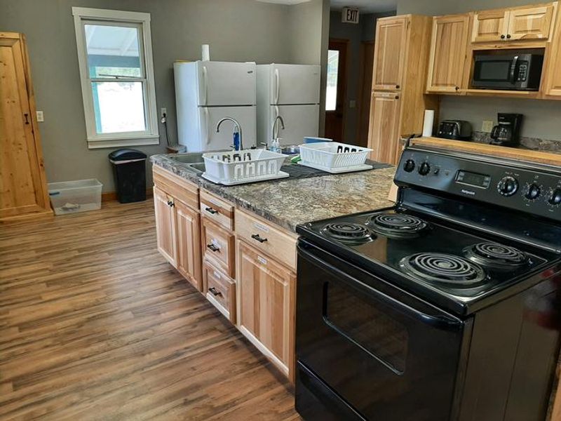
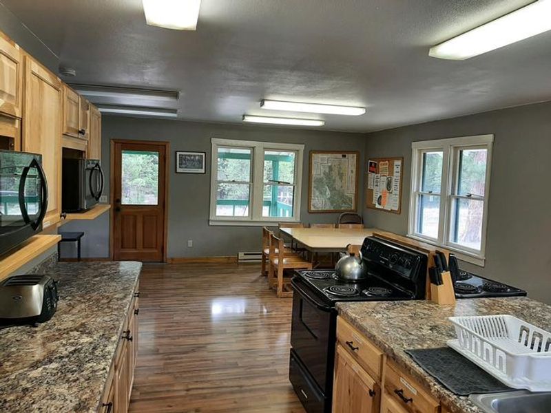
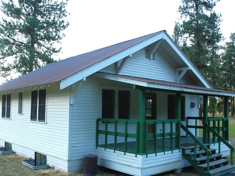
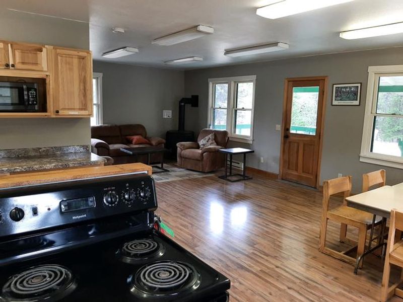
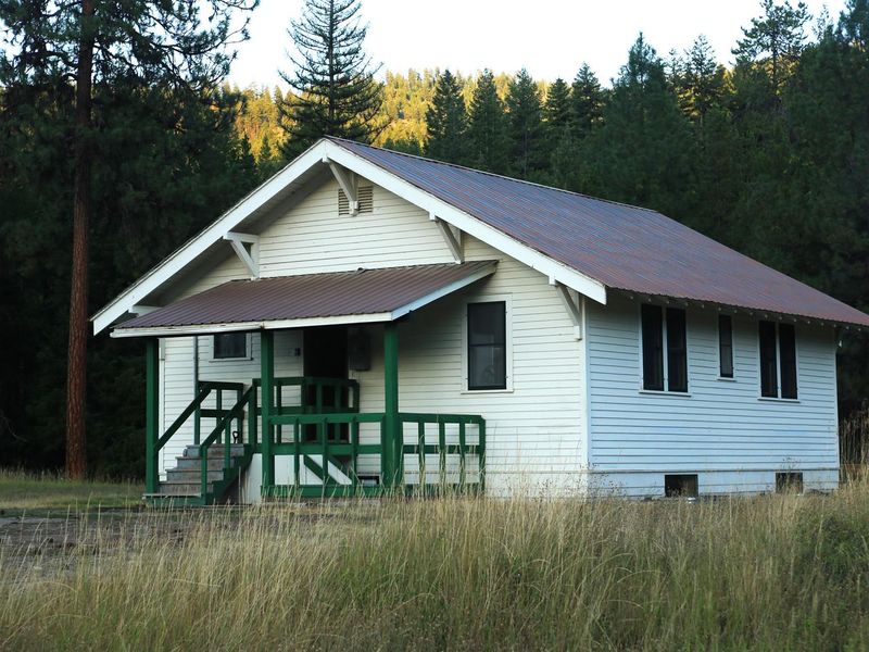
The Bend Guard Station offers a unique lodging experience in a historic Forest Service site within Lolo National Forest. The rental is the combined bunkhouse and cookhouse building, originally constructed in 1923 to house Forest Service work crews and rangers. The two-story cabin features four bedrooms with bunk beds and mattresses, two bathrooms with flush toilets and hot showers, and a large kitchen equipped with two electric stoves, two microwaves, two refrigerators, and running hot and cold water. The cabin sits in an open meadow surrounded by evergreen forest at 3,200 feet elevation. The Thompson River is a short walk away, offering fishing for trout and mountain whitefish. The area provides year-round recreation including hiking, mountain biking, cross-country skiing, snowmobiling, and berry picking in season. The surrounding 2 million-acre forest is home to mountain goats, bighorn sheep, elk, moose, deer, bears, eagles, and trumpeter swans. Access requires navigating 32 miles of low-standard gravel and dirt roads from Highway 200. A high-clearance vehicle is recommended, and winter visitors may need to hike, ski, or snowmobile the final mile when roads are not plowed. There is no cell phone service at the cabin.
Directions
Located approximately 32 miles up Thompson River Road (County Road 556) from its junction with Montana Highway 200, five miles east of Thompson Falls. Can also be accessed from US Highway 2 by turning south on Thompson River Road between McGregor Lake and Lower Thompson Lake, approximately 40 miles west of Kalispell. Roads are low-standard gravel or dirt and often rough. High-clearance vehicle with tire chains recommended; four-wheel drive highly recommended. Winter access may require hiking, skiing, or snowmobiling the final mile.
Amenities
| Water | Yes |
| Fires Allowed | — |
| Toilets | Yes |
| Dump Station | — |
| Wifi | No |
| Pets Allowed | No |
| Showers | Yes |
| Electric Hookups | — |
| Water Hookups | — |
| Sewer Hookups | — |
| Camp Store | No |
| Price | $90 |
Vehicle
| Max RV Length | — |
| Max Trailer Length | — |
| Big Rig Friendly | No |
| Pull Through Sites | No |
Contact
| Phone | +1 (406) 826-3821 |
Cell Service
| AT&T | None |
| Verizon | None |
| T-Mobile | None |
Availability
Photos

Community Posts
No posts yet. Be the first to share your experience!