Silvertip Cabin
Closed for the season. The cabin operates weekends only from July 1 through Labor Day weekend. Road 38 and Road 568 have winter wildlife closures from December 1 through May 14. Reservations available via Recreation.gov.
Northern Region Camping & Target Restrictions, Pallet Prohibition
This order defines the maximum length of occupation at a single location or cumulatively at any number of locations within a calendar year, within the states of Montana, North Dakota, South Dakota, and Idaho
Weed Free Forage & Mulch Products Order for the Northern Region
It is illegal to possess, store or transport straw, hay, grain, seed or other forage or mulch products on Forest Service lands without documentation that the product is certified as “weed free” by a state certification process that meets or exceeds the North American Weed Free Forage standards.
R1-2023-02 - NCDE Food and Wildlife Attractant Storage Order
Northern Continental Divide Ecosystem Food/Wildlife Attractant Storage Order for the Flathead, Lolo, Kootenai, Helena-Lewis and Clark, and Beaverhead-Deerlodge National Forests within the Northern Continental Divide Ecosystem.
About
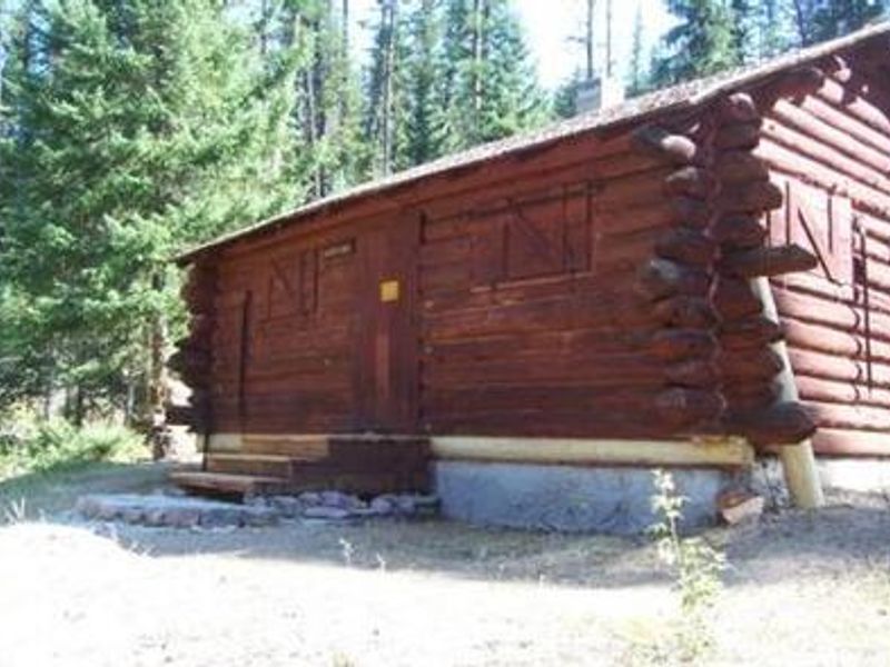
Silvertip Cabin offers a true backcountry experience in Montana's Flathead National Forest, wedged between the Great Bear Wilderness to the north and Bob Marshall Wilderness to the west. The rustic log cabin sits in a stand of mixed conifers near the Spotted Bear River, providing access to exceptional hiking and horseback riding trails into two premier wilderness areas. The cabin accommodates up to 8 guests with six single beds and two cots. Interior amenities include a wood stove for heat, propane stove and lights, basic cooking utensils, and a sink with running unfiltered water from a spring. A bag filter is provided but water should be treated before drinking. Outside, a vault toilet, corral, and hitchrail serve guests with stock animals. Certified weed-free feed is required for horses. Groups must hike or ride approximately 1.5 miles from Silvertip Trailhead during July-August, or 4.5 miles from Beaver Creek Campground when the upper road is gated in early season and September. There is no cell service, and the nearest phone, gas, and groceries are 70 miles away in Hungry Horse. Grizzly bears frequent the area; all food and attractants must remain inside the cabin.
Directions
From Hungry Horse, drive east on Highway 2 to Martin City, then south on Forest Road 38 for approximately 54 miles along Hungry Horse Reservoir. Turn east on Forest Road 568 and drive 14 miles to Silvertip Trailhead. Hike or ride 1.5 miles on Spotted Bear River Trail 83 to the cabin. From July 1-August 31, the full road is accessible. Before July 1 and after August 31, a gate closes the upper road and access is via Beaver Creek Campground Trailhead, making the hike 4.5 miles.
Location
Amenities
| Water | No |
| Fires Allowed | No |
| Toilets | Yes |
| Dump Station | No |
| Wifi | No |
| Pets Allowed | Yes |
| Showers | No |
| Electric Hookups | — |
| Water Hookups | — |
| Sewer Hookups | — |
| Camp Store | No |
| Price | $50 |
Vehicle
| Max RV Length | — |
| Max Trailer Length | — |
| Big Rig Friendly | No |
| Pull Through Sites | No |
Contact
| Phone | +1 (406) 758-5376 |
Cell Service
| AT&T | None |
| Verizon | None |
| T-Mobile | None |
Availability
Photos
Community Posts
No posts yet. Be the first to share your experience!