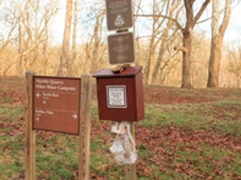
Marble Quarry Hiker-biker Campsite
Open year-round, free, first-come first-served with no reservations. Stays limited to one night per site per trip. Non-potable well water is available mid-April through mid-November and must be treated before use. Water is shut off mid-November through mid-April.
Severe Thunderstorm Warning issued July 21 at 7:44PM EDT until July 21 at 8:15PM EDT by NWS Baltimore MD/Washington DC
SVRLWX The National Weather Service in Sterling Virginia has issued a * Severe Thunderstorm Warning for... West central Montgomery County in central Maryland... East central Loudoun County in northern Virginia... * Until 815 PM EDT. * At 744 PM EDT, a severe thunderstorm was located near Oatlands, or near Leesburg, moving east at 40 mph. HAZARD...60 mph wind gusts and quarter size hail. SOURCE...Radar indicated. IMPACT...Damaging winds will cause some trees and large branches to fall. This could injure those outdoors, as well as damage homes and vehicles. Roadways may become blocked by downed trees. Localized power outages are possible. Unsecured light objects may become projectiles. * Locations impacted include... Germantown, Leesburg, Herndon, Broadlands, Lansdowne, Lowes Island, Brambleton, Poolesville, Ashburn, Sterling, Great Falls, Countryside, Oatlands, Darnestown, Belmont, Hamilton, Paeonian Springs, Gleedsville, Dawsonville, and Sterling Park.
Flash Flood Warning issued July 21 at 6:47PM EDT until July 21 at 10:00PM EDT by NWS Baltimore MD/Washington DC
FFWLWX The National Weather Service in Sterling Virginia has issued a * Flash Flood Warning for... Central Howard County in central Maryland... Northeastern Montgomery County in central Maryland... * Until 1000 PM EDT. * At 647 PM EDT, Doppler radar indicated thunderstorms producing heavy rain across the warned area. Between 2 and 3 inches of rain have fallen. Additional rainfall amounts of 1 to 2 inches are possible in the warned area. Flash flooding is ongoing or expected to begin shortly. HAZARD...Flash flooding caused by thunderstorms. SOURCE...Radar. IMPACT...Flash flooding of small creeks and streams, urban areas, highways, streets and underpasses as well as other poor drainage and low-lying areas. * Some locations that will experience flash flooding include... Columbia... Germantown... Olney... Damascus... Montgomery Village... Clarksburg... Highland... Laytonsville... Roxbury Mills... Dayton... Glenelg... Clarksville...
Flood Watch issued July 21 at 6:17PM EDT until July 22 at 2:00AM EDT by NWS Baltimore MD/Washington DC
* WHAT...Flash flooding caused by excessive rainfall continues to be possible. * WHERE...Portions of central, north central, northeast, and northern Maryland, including the following areas, in central Maryland, Central and Southeast Howard, Central and Southeast Montgomery, Northwest Howard and Northwest Montgomery. In north central Maryland, Carroll and Frederick. In northeast Maryland, Cecil. In northern Maryland, Northern Baltimore, Northwest Harford, Southeast Harford and Southern Baltimore. * WHEN...Until 2 AM EDT Wednesday. * IMPACTS...Excessive runoff may result in flooding of rivers, creeks, streams, and other low-lying and flood-prone locations. Flooding may occur in poor drainage and urban areas. Extensive street flooding and flooding of creeks and rivers are possible. * ADDITIONAL DETAILS... - Repeated very heavy rain may result in areas of 3 to 6 inches of rainfall and considerable flash flooding this evening. - Please visit www.weather.gov/safety/flood for flood safety and preparedness information
About
Marble Quarry Hiker-Biker Campsite is one of numerous primitive campsites spaced every 5-7 miles along the historic Chesapeake and Ohio Canal towpath. Located at Mile 38.2 near Poolesville, Maryland, it provides a convenient overnight stop for long-distance hikers and cyclists traversing the 184.5-mile trail between Georgetown and Cumberland. The campsite operates on a no-fee, first-come first-served basis with no reservations accepted. Overnight stays are limited to one night per site per trip. Standard amenities include a chemical toilet, picnic table, and fire ring. Non-potable well water is available seasonally from mid-April through mid-November, but must be filtered, chemically treated, or boiled before consumption. Campers must pack out all trash as this is a trash-free park. Fires are restricted to the provided fire rings or portable grills positioned off the ground. Pets are welcome but must remain leashed at all times. Quiet hours are enforced from 10 PM to 6 AM. The site can accommodate approximately 5-10 tents depending on configuration.
Directions
Located at mile 38.2 on the C&O Canal towpath near Poolesville, MD. Accessible only by foot, bicycle, or horseback via the towpath.
Nearby Campgrounds
Location
Amenities
| Water | No |
| Fires Allowed | Yes |
| Toilets | Yes |
| Dump Station | No |
| Wifi | — |
| Pets Allowed | Yes |
| Showers | No |
| Electric Hookups | — |
| Water Hookups | — |
| Sewer Hookups | — |
| Camp Store | No |
| Price | $0 |
Vehicle
| Max RV Length | — |
| Max Trailer Length | — |
| Big Rig Friendly | No |
| Pull Through Sites | No |
Contact
| CHOH_information@nps.gov | |
| Phone | +1 (301) 739-4200 |
Cell Service
| AT&T | None |
| Verizon | Yes |
| T-Mobile | Yes |
Photos

Community Posts
No posts yet. Be the first to share your experience!