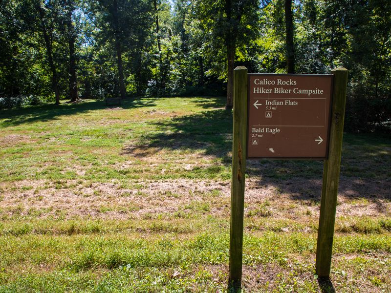
Calico Rocks Hiker-biker Overnight Campsite
Open year-round, first-come first-served, no fee. Well water is available mid-April through mid-November but is non-potable and requires treatment before use. Water handles are removed mid-November through mid-April for freeze protection.
Severe Thunderstorm Warning issued June 11 at 7:54PM EDT until June 11 at 8:30PM EDT by NWS Baltimore MD/Washington DC
SVRLWX The National Weather Service in Sterling Virginia has issued a * Severe Thunderstorm Warning for... The District of Columbia... Western Baltimore County in northern Maryland... Carroll County in north central Maryland... Northwestern Anne Arundel County in central Maryland... Northwestern Charles County in southern Maryland... Howard County in central Maryland... Montgomery County in central Maryland... Eastern Frederick County in north central Maryland... Central Prince Georges County in central Maryland... Northeastern Orange County in central Virginia... The northern City of Fredericksburg in central Virginia... Southeastern Fauquier County in northern Virginia... The City of Manassas Park in northern Virginia... The City of Manassas in northern Virginia... East central Madison County in northwestern Virginia... The City of Fairfax in northern Virginia... Arlington County in northern Virginia... North central Spotsylvania County in central Virginia... Stafford County in northern Virginia... Southeastern Loudoun County in northern Virginia... The City of Falls Church in northern Virginia... Fairfax County in northern Virginia... Southern Culpeper County in northern Virginia... Prince William County in northern Virginia... Northwestern King George County in central Virginia... The City of Alexandria in northern Virginia... * Until 830 PM EDT. * At 753 PM EDT, severe thunderstorms were located along a line extending from 8 miles west of Stafford to near Burke to near Great Falls to near Montgomery Village to near Mount Airy to 8 miles northwest of Sykesville to near Littlestown, moving east at 45 mph. HAZARD...60 mph wind gusts. SOURCE...Emergency Management has reported many instances of trees down with this line of storms. IMPACT...Damaging winds will cause some trees and large branches to fall. This could injure those outdoors, as well as damage homes and vehicles. Roadways may become blocked by downed trees. Localized power outages are possible. Unsecured light objects may become projectiles. * Locations impacted include... Arlington, Alexandria, Stafford, Columbia, Germantown, Centreville, Waldorf, Dale City, Rockville, Bethesda, Gaithersburg, Reston, Bowie, Leesburg, Annandale, Clinton, Olney, Pikesville, Springfield, and College Park.
Severe Thunderstorm Watch issued June 11 at 7:53PM EDT until June 11 at 10:00PM EDT by NWS Baltimore MD/Washington DC
SEVERE THUNDERSTORM WATCH 315 REMAINS VALID UNTIL 10 PM EDT THIS EVENING FOR THE FOLLOWING AREAS THE DISTRICT OF COLUMBIA IN MARYLAND THIS WATCH INCLUDES 9 COUNTIES IN CENTRAL MARYLAND ANNE ARUNDEL HOWARD MONTGOMERY PRINCE GEORGES IN NORTH CENTRAL MARYLAND CARROLL FREDERICK IN NORTHERN MARYLAND BALTIMORE BALTIMORE CITY HARFORD IN VIRGINIA THIS WATCH INCLUDES 12 COUNTIES IN NORTHERN VIRGINIA ARLINGTON CITY OF ALEXANDRIA CITY OF FAIRFAX CITY OF FALLS CHURCH CITY OF MANASSAS CITY OF MANASSAS PARK CULPEPER FAIRFAX FAUQUIER LOUDOUN PRINCE WILLIAM IN NORTHWEST VIRGINIA RAPPAHANNOCK THIS INCLUDES THE CITIES OF ABERDEEN, ABINGDON, ADAMS MORGAN, ADEN, AIRLIE, ALEXANDRIA, ANNANDALE, ANNAPOLIS, ARLINGTON, ARNOLD, BALLENGER CREEK, BALLSTON, BALTIMORE, BARCROFT, BETHEL, BETHESDA, BOWIE, BOYDS, BUCKEYSTOWN, BURKE, BYNUM, CARDOVA, CATALPA, CATONSVILLE, CHANTILLY, CHERRYDALE, CHESTER GAP, CLARKSVILLE, CLINTON, COLLEGE PARK, COLUMBIA, COUNTRYSIDE, CULPEPER, DALE CITY, DULLES INTERNATIONAL AIRPORT, DUNDALK, EDGEWOOD, ELDERSBURG, ESSEX, FAIRFAX, FAIRFAX STATION, FALLS CHURCH, FELLS POINT, FOUR CORNERS, FREDERICK, GAITHERSBURG, GAMBER, GERMANTOWN, GLEEDSVILLE, GLEN BURNIE, GLENMONT, GREENBELT, HARFORD FURNACE, HICKORY, HISTORIC ELLICOTT CITY, INDEPENDENT HILL, LAKE RIDGE, LANGLEY, LEESBURG, LUCKETTS, MAGNOLIA, MANASSAS, MANASSAS PARK, MCLEAN, MONTCLAIR, MONTPELIER, OAK GROVE, PARK HEIGHTS, PARK MILLS, PARKVILLE, RANDALLSTOWN, RAPIDAN, REAGAN NATIONAL AIRPORT, RESTON, REVA, RIDGEWAY, RIVERCREST, ROSSLYN, SEVERN, SEVERNA PARK, SILVER SPRING, SIMPSONVILLE, SOUTH GATE, STERLING PARK, STEVENSBURG, SUITLAND-SILVER HILL, TANTALLON, TOWSON, TURNBULL, WARRENTON, WASHINGTON, WESTMINSTER, WINSTON, WOODBRIDGE, WOODLAWN, AND WOODSTOCK.
About
Calico Rocks Hiker-Biker Campsite is one of 30 primitive campsites spaced every 5-7 miles along the 184.5-mile C&O Canal towpath. Located at Mile 47.6 near Point of Rocks, Maryland, it serves through-hikers and cyclists traveling the historic towpath between Georgetown and Cumberland. The campsite is free with no reservations required and operates on a first-come, first-served basis. Overnight stays are limited to one night per site per trip. Standard amenities include a chemical toilet, picnic table, fire pit, and a hand-pump well. The well water is non-potable and must be filtered, chemically treated, or boiled before drinking or cooking. The site is positioned 1-5 miles from the nearest parking area and is accessible only on foot or by bicycle. Campers must pack out all trash as this is a trash-free park. Pets are allowed but must be kept on a leash at all times. The campsite can accommodate 5-10 tents depending on configuration.
Directions
Located at mile 47.6 along the C&O Canal towpath, accessible only by foot or bicycle. Near Point of Rocks, Maryland.
Nearby Campgrounds
Amenities
| Water | No |
| Fires Allowed | Yes |
| Toilets | Yes |
| Dump Station | No |
| Wifi | No |
| Pets Allowed | Yes |
| Showers | No |
| Electric Hookups | — |
| Water Hookups | — |
| Sewer Hookups | — |
| Camp Store | No |
| Price | $0 |
Vehicle
| Max RV Length | — |
| Max Trailer Length | — |
| Big Rig Friendly | No |
| Pull Through Sites | No |
Contact
| choh_information@nps.gov | |
| Phone | +1 (301) 739-4200 |
Cell Service
| AT&T | Yes |
| Verizon | Yes |
| T-Mobile | Yes |
Photos
Community Posts
No posts yet. Be the first to share your experience!