Burnsville Lake Shelters
This is a day-use picnic shelter facility, not an overnight campground. Shelters can be reserved through Recreation.gov for daytime gatherings. For overnight camping at Burnsville Lake, use Bulltown Camp or Riffle Run Campground.
Flood Watch issued July 21 at 7:38PM EDT until July 22 at 2:00AM EDT by NWS Charleston WV
* WHAT...Flash flooding caused by excessive rainfall continues to be possible. * WHERE...Portions of northeast Kentucky, including the following counties, Boyd, Carter, Greenup and Lawrence, southeast Ohio, including the following counties, Athens, Gallia, Jackson OH, Lawrence OH, Meigs, Morgan, Vinton and Washington, southwest Virginia, including the following counties, Buchanan and Dickenson, and West Virginia, including the following counties, Barbour, Boone, Braxton, Cabell, Calhoun, Clay, Doddridge, Gilmer, Harrison, Jackson WV, Kanawha, Lewis, Lincoln, Logan, Mason, McDowell, Mingo, Northwest Fayette, Northwest Nicholas, Northwest Pocahontas, Northwest Raleigh, Northwest Randolph, Northwest Webster, Pleasants, Putnam, Ritchie, Roane, Southeast Fayette, Southeast Nicholas, Southeast Raleigh, Southeast Randolph, Southeast Webster, Taylor, Tyler, Upshur, Wayne, Wirt, Wood and Wyoming. * WHEN...Until 2 AM EDT Wednesday. * IMPACTS...Excessive runoff may result in flooding of rivers, creeks, streams, and other low-lying and flood-prone locations. Flooding may occur in poor drainage and urban areas. Low-water crossings may be flooded. Storm drains and ditches may become clogged with debris. * ADDITIONAL DETAILS... - Heavy rainfall from thunderstorms may result in flash flooding. Some storms will be capable of producing 2 to 3 inches of rain in as little as an hour. - http://www.weather.gov/safety/flood
Severe Thunderstorm Watch issued July 21 at 7:30PM EDT until July 21 at 11:00PM EDT by NWS Charleston WV
SEVERE THUNDERSTORM WATCH 506, PREVIOUSLY IN EFFECT UNTIL 8 PM EDT THIS EVENING, IS NOW IN EFFECT UNTIL 11 PM EDT THIS EVENING FOR THE FOLLOWING AREAS IN KENTUCKY THIS WATCH INCLUDES 1 COUNTY IN NORTHEAST KENTUCKY LAWRENCE IN WEST VIRGINIA THIS WATCH INCLUDES 22 COUNTIES IN CENTRAL WEST VIRGINIA BRAXTON CALHOUN CLAY GILMER NICHOLAS ROANE TAYLOR WEBSTER IN NORTHERN WEST VIRGINIA BARBOUR DODDRIDGE HARRISON LEWIS POCAHONTAS RANDOLPH UPSHUR IN SOUTHERN WEST VIRGINIA BOONE FAYETTE KANAWHA LINCOLN PUTNAM IN WESTERN WEST VIRGINIA CABELL WAYNE THIS INCLUDES THE CITIES OF ALUM CREEK, BELINGTON, BRIDGEPORT, BUCKHANNON, BURNSVILLE, CEREDO, CHARLESTON, CLARKSBURG, CLAY, COWEN, CRAIGSVILLE, ELKINS, FAYETTEVILLE, GASSAWAY, GLENVILLE, GRAFTON, GRANTSVILLE, HAMLIN, HARTS, HOLLY RIVER STATE PARK, HUNTINGTON, HURRICANE, KENOVA, LOUISA, MADISON, MARLINTON, OAK HILL, PHILIPPI, RICHWOOD, SAINT ALBANS, SOUTH CHARLESTON, SPENCER, SUMMERSVILLE, SUTTON, TEAYS VALLEY, WAYNE, WEBSTER SPRINGS, WEST UNION, WESTON, AND YATESVILLE LAKE STATE PARK.
Flash Flood Warning issued July 21 at 6:15PM EDT until July 21 at 10:15PM EDT by NWS Charleston WV
FFWRLX The National Weather Service in Charleston has issued a * Flash Flood Warning for... Northeastern Braxton County in north central West Virginia... Northern Gilmer County in north central West Virginia... Central Lewis County in northern West Virginia... Southern Ritchie County in northwestern West Virginia... * Until 1015 PM EDT. * At 615 PM EDT, Doppler radar indicated thunderstorms producing heavy rain across the warned area. Between 1 and 2 inches of rain have fallen. Additional rainfall amounts of 0.5 to 1 inch are possible in the warned area. Flash flooding is ongoing or expected to begin shortly. HAZARD...Flash flooding caused by thunderstorms. SOURCE...Radar indicated. IMPACT...Flash flooding of small creeks and streams, urban areas, highways, streets and underpasses as well as other poor drainage and low-lying areas. * Some locations that will experience flash flooding include... Weston, Harrisville, Glenville, North Bend State Park, Stonewall Jackson, Ellenboro, Cairo, Sand Fork, Pullman, Auburn, Coxs Mills, Newberne, Troy, Tanner, Linn, Baldwin, Burnt House, Stouts Mills, Alum Bridge and Smithville. This includes the following highways... Interstate 79 between mile markers 81 and 96. Route 50 in West Virginia between mile markers 32 and 36.
About
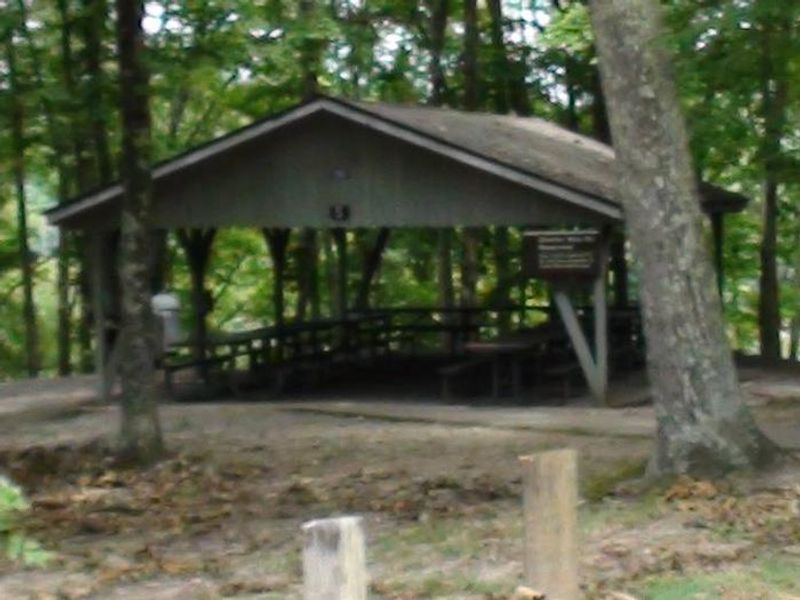
Burnsville Lake Shelters provide six reservable group picnic shelters scattered across two areas of Burnsville Lake in West Virginia. Shelters 1-4 are located in the downstream area near the dam, while shelters 5-6 are upstream at the Bulltown Day Use Area near the Little Kanawha River inflow and adjacent to the historic Bulltown Civil War village and visitor center. Each shelter is equipped with drinking water and a large charcoal grill for group cooking. Flush toilets and playgrounds are located nearby. Shelters 3 and 5 offer electrical hookups for events requiring power. The reservoir, built in 1978 for flood control, sits between the Allegheny Mountains and Allegheny Plateau amid steep, forested hills. This is a day-use facility for picnicking and group gatherings. Popular activities in the area include biking, hiking, and fishing. For overnight camping at Burnsville Lake, visitors should look to Bulltown Camp or Riffle Run Campground instead.
Directions
For Shelters 1-4 (near dam): From Clarksburg, drive south on I-79 to Exit 79 (Burnsville). Turn left through town to the junction, then right onto Route 5 East. Follow approximately 2.5 miles and turn right into the downstream area. Shelter 1 is near the restroom; Shelter 2 is by the playground below the dam; Shelters 3-4 are in the Left Fork area by the boat ramp. For Shelters 5-6 (upstream): From Clarksburg, drive south on I-79 to Exit 67 (Flatwoods). Turn left at the stop light onto Route 19 North and follow for 10 miles. Shelters are on the left at the Confederate Overlook, adjacent to Bulltown Historical Village.
Amenities
| Water | Yes |
| Fires Allowed | — |
| Toilets | Yes |
| Dump Station | — |
| Wifi | — |
| Pets Allowed | — |
| Showers | — |
| Electric Hookups | — |
| Water Hookups | — |
| Sewer Hookups | — |
| Camp Store | — |
| Price | $40 - $50 |
Vehicle
| Max RV Length | — |
| Max Trailer Length | — |
| Big Rig Friendly | — |
| Pull Through Sites | No |
Contact
| Phone | +1 (304) 853-2371 |
Cell Service
| AT&T | None |
| Verizon | None |
| T-Mobile | None |
Availability
Photos
Community Posts
No posts yet. Be the first to share your experience!