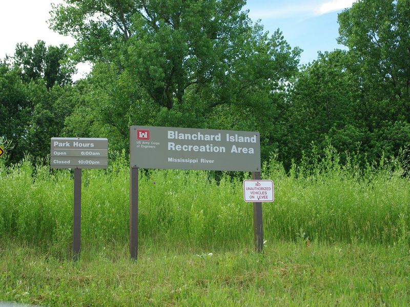
Pickup Truck Campers along river campsites

Blanchard Island Recreation Area

Open

Open for the 2026 season from May 15 through October 15. All sites are first-come, first-served using the Scan & Pay system via the Recreation.gov mobile app. Credit card only; cash not accepted. No refunds for early departure.

The Tornado Watch has been cancelled.

6:06 PM — 6:21 PM

The Tornado Watch has been cancelled and is no longer in effect.

Tornado Watch issued June 11 at 3:16PM CDT until June 11 at 3:00PM CDT by NWS Quad Cities IA IL

3:16 PM — 9:00 PM

THE NATIONAL WEATHER SERVICE HAS ISSUED TORNADO WATCH 313 UNTIL 9 PM CDT THIS EVENING. TORNADO WATCH 311 HAS EXPIRED. THE NEW WATCH IS VALID FOR THE FOLLOWING AREAS IN ILLINOIS THE NEW WATCH INCLUDES 13 COUNTIES IN NORTH CENTRAL ILLINOIS BUREAU PUTNAM IN NORTHWEST ILLINOIS CARROLL HENRY IL JO DAVIESS MERCER ROCK ISLAND STEPHENSON WHITESIDE IN WEST CENTRAL ILLINOIS HANCOCK HENDERSON MCDONOUGH WARREN IN IOWA THE NEW WATCH INCLUDES 17 COUNTIES IN EAST CENTRAL IOWA CEDAR CLINTON IOWA JACKSON JOHNSON JONES LINN MUSCATINE SCOTT IN SOUTHEAST IOWA DES MOINES HENRY IA JEFFERSON KEOKUK LEE LOUISA VAN BUREN WASHINGTON IN MISSOURI THE NEW WATCH INCLUDES 2 COUNTIES IN NORTHEAST MISSOURI CLARK SCOTLAND THIS INCLUDES THE CITIES OF ALEDO, ANAMOSA, BETTENDORF, BURLINGTON, CARTHAGE, CEDAR RAPIDS, CLINTON, CREDIT ISLAND, DAVENPORT, FAIRFIELD, FREEPORT, GALENA, GENESEO, HENNEPIN, IOWA CITY, KAHOKA, KEOKUK, KEOSAUQUA, MACOMB, MAQUOKETA, MARENGO, MEMPHIS, MOLINE, MONMOUTH, MOUNT CARROLL, MOUNT PLEASANT, MUSCATINE, OQUAWKA, PRINCETON, ROCK ISLAND, SIGOURNEY, STERLING, TIPTON, WAPELLO, AND WASHINGTON.

Flood Watch issued June 11 at 2:51PM CDT until June 11 at 7:00PM CDT by NWS Quad Cities IA IL

2:51 PM — 7:00 PM

One more round of thunderstorms this afternoon could lead to heavy rainfall and flooding. Although these storms will be fast-moving, they will have high rainfall rates, so areas that had storms this morning could be susceptible to runoff and flooding. * WHAT...Flooding caused by excessive rainfall continues to be possible. * WHERE...Portions of Illinois, including the following areas, Bureau, Carroll, Hancock, Henderson, Henry IL, Jo Daviess, McDonough, Mercer, Putnam, Rock Island, Stephenson, Warren and Whiteside, Iowa, including the following areas, Benton, Buchanan, Cedar, Clinton, Delaware, Des Moines, Dubuque, Henry IA, Iowa, Jackson, Jefferson, Johnson, Jones, Keokuk, Lee, Linn, Louisa, Muscatine, Scott, Van Buren and Washington, and northeast Missouri, including the following areas, Clark and Scotland. * WHEN...Until 7 PM CDT this evening. * IMPACTS...Excessive runoff may result in flooding of rivers, creeks, streams, and other low-lying and flood-prone locations. Creeks and streams may rise out of their banks.

Flood Warning issued June 11 at 9:52AM CDT until June 16 at 9:00AM CDT by NWS Quad Cities IA IL

9:52 AM — June 12th, 10:00 AM

...The Flood Warning continues for the following rivers in Iowa... Maquoketa River near Maquoketa affecting Jackson County. Cedar River near Conesville affecting Louisa and Muscatine Counties. Iowa River near Lone Tree affecting Louisa, Washington and Johnson Counties. English River at Kalona affecting Washington and Johnson Counties. Skunk River at Augusta affecting Henry IA, Des Moines and Lee Counties. Wapsipinicon River near De Witt 4S affecting Scott and Clinton Counties. ...The Flood Warning is extended for the following rivers in Illinois... Rock River near Joslin affecting Henry IL, Rock Island and Whiteside Counties. Rock River at Moline affecting Henry IL and Rock Island Counties. .Several rounds of heavy rainfall will produce flooding on several tributary rivers. * WHAT...Minor flooding is forecast. * WHERE...Rock River at Moline. * WHEN...From Saturday morning to late Tuesday morning. * IMPACTS...At 12.5 feet, Water affects some residences in the lower Friendship Farm area. 60th St is under water south of the Green Valley Sports Complex. 56th St along the north side of the river is under water. * ADDITIONAL DETAILS... - At 9:30 AM CDT Thursday the stage was 9.4 feet. - Forecast...The river is expected to rise above flood stage late Saturday morning to a crest of 12.7 feet Sunday morning. It will then fall below flood stage early Tuesday morning. - Flood stage is 12.0 feet.

Flood Warning issued June 11 at 9:52AM CDT until June 15 at 9:00PM CDT by NWS Quad Cities IA IL

9:52 AM — June 12th, 10:00 AM

...The Flood Warning continues for the following rivers in Iowa... Maquoketa River near Maquoketa affecting Jackson County. Cedar River near Conesville affecting Louisa and Muscatine Counties. Iowa River near Lone Tree affecting Louisa, Washington and Johnson Counties. English River at Kalona affecting Washington and Johnson Counties. Skunk River at Augusta affecting Henry IA, Des Moines and Lee Counties. Wapsipinicon River near De Witt 4S affecting Scott and Clinton Counties. ...The Flood Warning is extended for the following rivers in Illinois... Rock River near Joslin affecting Henry IL, Rock Island and Whiteside Counties. Rock River at Moline affecting Henry IL and Rock Island Counties. .Several rounds of heavy rainfall will produce flooding on several tributary rivers. * WHAT...Minor flooding is forecast. * WHERE...Rock River near Joslin. * WHEN...From Saturday morning to late Monday evening. * IMPACTS...At 12.5 feet, Water affects some summer cottages along the river. * ADDITIONAL DETAILS... - At 8:45 AM CDT Thursday the stage was 6.9 feet. - Forecast...The river is expected to rise above flood stage late Saturday morning to a crest of 12.5 feet early Sunday morning. It will then fall below flood stage early Monday afternoon. - Flood stage is 12.0 feet.

About

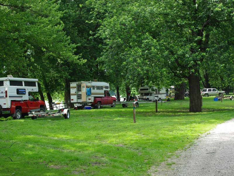
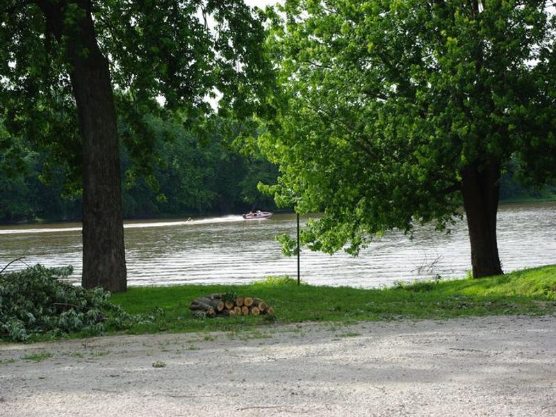
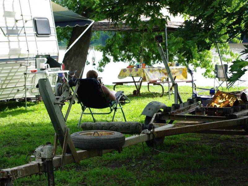
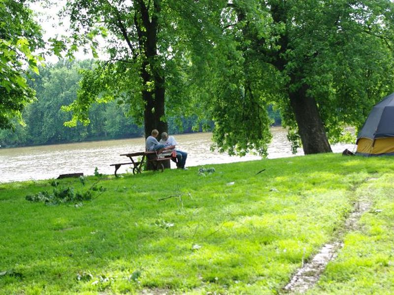
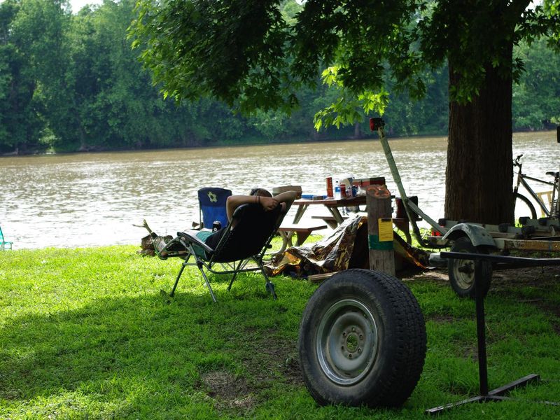
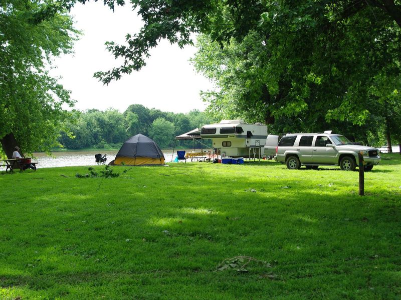
Blanchard Island Recreation Area offers a secluded camping experience along Blanchard Chute on the Mississippi River backwaters. Operated by the U.S. Army Corps of Engineers Rock Island District, this 15-site campground provides a tranquil escape with excellent opportunities for catfish fishing, deer hunting in season, and wildlife observation including bald eagles, pileated woodpeckers, deer, muskrats, and otters. 
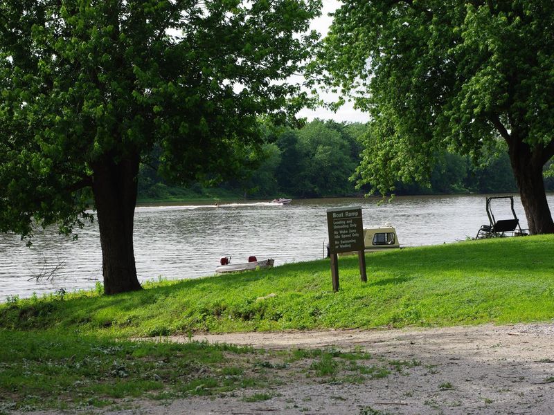
The campground features concrete vault toilets, potable water hydrants distributed throughout the park, and a dump station. Each campsite includes a picnic table and fire ring. A boat ramp provides river access for anglers seeking the best catfish holes. Sites are standard nonelectric with a maximum occupancy of 6 campers and 2 vehicles per site. Reaching the campground requires navigating approximately 2.5 miles of gravel road and crossing over a levee. While the journey adds to the backcountry feel, campers should come prepared with bug spray. The peaceful setting and natural views of the river and bottomlands make it well worth the drive.

Directions

From Muscatine, IA, cross the Muscatine Bridge into Illinois. Drive approximately 2 miles on Highway 92, then turn right onto 322nd St. W for about 4.5 miles. Turn right onto 176th St. W (gravel road) and follow it approximately 2.5 miles to the levee. Cross over the levee to enter the park. Address: 34000 176th Ave. W., New Boston, IL 61272.

Amenities

Water Yes
Fires Allowed Yes
Toilets Yes
Dump Station Yes
Wifi
Pets Allowed Yes
Showers
Electric Hookups
Water Hookups
Sewer Hookups
Camp Store
Price $14

Vehicle

Max RV Length
Max Trailer Length
Big Rig Friendly
Pull Through Sites No

Contact

Email mvrodmn16@usace.army.mil
Phone +1 (563) 263-7913

Cell Service

AT&T Yes
Verizon Yes
T-Mobile Yes

Availability

Photos

Pickup Truck Campers along river campsites
Boater on water.
Camper looking out over the river from lawn chair and trailer
BI Entrance Sign
Father/Son on table along river with tent
Lounge Chair overlooking the river.
BI Boat Ramp and Boats along shoreline
Popup Camper and Tent along river campsite

Community Posts

No posts yet. Be the first to share your experience!