
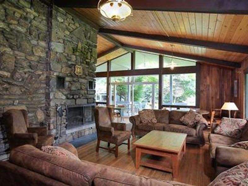
Balsam Lake Lodge
Closed — Closed for the season. The lodge operates from early April through late November and is available by advance reservation only through Recreation.gov.
Temporary Road Closure Alert: Curtis Creek Road
Curtis Creek Road will close starting Monday, March 30, just past the Newberry Creek Road intersection, to build a boulder wall that will stabilize the roadway following Hurricane Helene. The closure is needed to reopen Curtis Creek Campground by mid May.This 6-week repair project is a partnership…
Catawba Falls Partial Closure
A partial closure of Catawba Falls trail will take place this Wednesday and Thursday, March 25 and 26. Due to the ongoing Helene recovery work in partnership with the G5 Trail Collective, the Ridge Trail between the parking lot and upper Catawba Falls will be closed for a period of time this…
Great Lakes Boat Launch- Temporary Closure
The Great Lakes Boat Launch will be closed for the safety of the public and fire crews during Prescribed Burn operations in Jonas County on Tuesday, March 24th.
Elk River Falls Temporary Re-Closure
Temporary Closure: Elk River Falls AreaClosure Order Closure Order MapStarting March 18, the Elk River Falls Area will be temporarily closed on the Pisgah National Forest. This includes closing the Elk River Trail, Elk River Falls and Elk River Road within the closure area in Avery County. The…
Connely Creek Road (NFSR 86) Closure
Connely Creek Road (NFSR 86) on the Nantahala Ranger District will be closed until October 2026 for road improvements. The closure will extend from the intersection of Cowee Bald Road (NFSR 70) to the intersection of Barkers Creek (NFSR 7062). Access to Cowee Bald will only be available from Macon…
Prescribed Burn Croatan National Forest
The Croatan National Forest is conducting a 1,323-acre prescribed burn today, February 24, in Jones County off Holston Creek Rd and Highway 58, approximately 7 miles South of Maysville, NC and 15 miles SW of the Croatan Ranger Station. Smoke may be visible in this area throughout the day.A…
Winter Weather Alert
As North Carolina prepares for Winter Storm Gianna, the U.S. Department of Agriculture’s Forest Service urges the public to use extreme caution when visiting the state’s four national forests.Winter weather conditions can make visiting the forest unpredictable and dangerous, even for…
Cold Springs Road, Pisgah National Forest Traffic Alert
Cold Springs Road (Forest Service Road 148) on the Appalachian Ranger District in Haywood County will have traffic disruptions of up to 3 hours at a time as culvert replacement takes place beginning Monday, September 29. Work will occur Monday-Thursday between the hours of 9 a.m. -3:30 p.m.
Roan Mountain Fire Restrictions
Fire restrictions are now in effect for the Roan Mountain area of Appalachian Ranger District due to heightened fire danger caused by Hurricane Helene. The fire restriction is in effect on all National Forest System land from Hughes Gap to Doll Flats on the Appalachian Trail.This…
Joyce Kilmer Memorial Forest and Jenkins Meadows Trailheads Closed for Parking Lot Repairs
Joyce Kilmer Memorial Forest and Jenkins Meadows trailhead on the Nantahala National Forest will be temporarily closed beginning the evening of July 28, 2025 for roadwork and needed parking lot repairs. Work should take approximately 2-3 days, but could be extended by weather delays. The public…
Pisgah National Forest Driving Safety Alert
Please use caution as you travel in and around the Forest. We have a lot of heavy equipment and repair crews in the area working on roads damaged during Hurricane Helene. Up to 2,000 tons of gravel are being placed EVERY DAY on our Forest Service roads through the summer and fall. That's around 60…
Joyce Kilmer Memorial Forest and Jenkins Meadow trailheads closed
The USDA Forest Service has closed Joyce Kilmer Road (Forest Service Road 416) on the Cheoah Ranger District of the Nantahala National Forest for repairs, impacting access to both the Joyce Kilmer and Jenkins Meadow trailheads. Work should take approximately three to five days but could be extended…
Croatan Ranger's Office Closed
The Croatan Ranger's Office will be closed June 7th and 8th to visitors and staff as work for the I42 Project will begin.
Flooding on Uwharrie National Forest
Moccasin Creek Road (#576) and McLeans Creek Road (#544) are experiencing flooding due to heavy rain on Uwharrie National Forest. Recreation areas and roads remain open, however, access may be limited due to current conditions. Caution is advised.
Paint Rock Closure
Effective through May 1, 2035, certain National Forest System lands in the Paint Rock area, located on the Appalachian Ranger District of Pisgah National Forest and the Unaka Ranger District of Cherokee National Forest, will be closed to protect cultural resources.This closure is intended to…
Appalachian Trail Detour- Iron Mountain Gap
The Iron Mountain Gap detour is now in place to route hikers around the final remaining 6 miles of closed section of the Appalachian Trail from about a mile south of the destroyed Cherry Gap Shelter to about a mile north of Iron Mountain Gap (approx. NOBO mile 360.6 to 365.9). The detour is mapped…
Kings Mountain Point Fishing Pier Closure
The fishing pier at Kings Mountain Point Day Use Area on the Uwharrie National Forest is closed till further notice due to storm damage. The Day Use area remains open and the three smaller accessible fishing platforms are available for public use.
I-40 Corridor Forest Closure
For the protection and public health and safety for the Interstate 40 reconstruction, a closure is in place for National Forest Service lands and roads south of the I-40 corridor in the Appalachian Ranger District. This includes areas south of Slick Rock Branch drainage, the area west of the Pigeon…
Pisgah Camping Limitations
The following act is prohibited within 1000 feet of a road open to public vehicle travel on the Pisgah Ranger District in Buncombe, Haywood, Henderson, and Transylvania Counties in North Carolina.Camping is prohibited in any area not designated as a campsite depicted on the attached map. This…
Max Patch Restrictions
Restrictions on camping, fires, animals, aircraft and bicycles in Max Patch area.
About
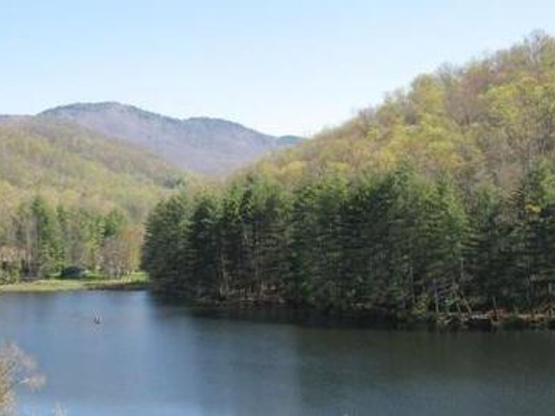
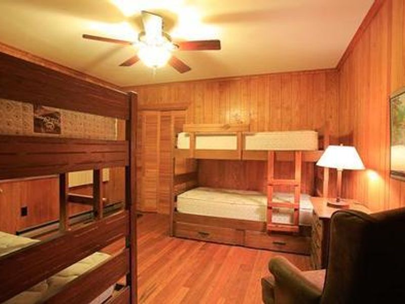
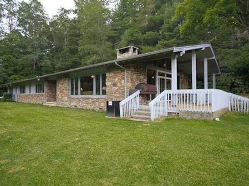
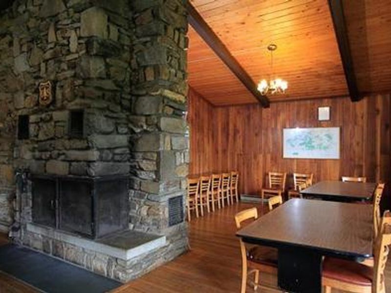
Balsam Lake Lodge is nestled in the center of the 39,000-acre Roy Taylor Forest within the Nantahala National Forest, offering spectacular views of Balsam Lake and the surrounding Blue Ridge Mountains. Acquired by the Forest Service in 1982, the lodge has since hosted groups for meetings, recreation, and environmental activities. The facility accommodates up to 16 guests with twin beds (some bunks), linens, towels, and pillows provided. The lodge features a fully equipped accessible kitchen with all utensils and appliances, three bathrooms with flush toilets, one roll-in wheelchair shower, a fireplace, gas heat, and outdoor grills. The property includes an 8-acre lake stocked with trout, accessible via several fishing piers including a wheelchair-accessible dock. Three short trails offer easy exploration: the wheelchair-suitable Robinson Trail leads to the fishing pier, the half-mile Malonee Trail follows the lakeshore to the day use area, and the 0.3-mile Wolf Creek Trail meanders beside a stream. Non-motorized boats and kayaks are permitted on the lake, though guests must bring their own. The lodge provides firewood, cleaning supplies, and has electricity but no cell service or wifi on-site. The location serves as an excellent base for exploring the Nantahala National Forest, renowned for its spectacular waterfalls including Whitewater Falls, the highest falls east of the Rocky Mountains. This is a whole-facility rental requiring advance reservations through Recreation.gov, with no walk-in or first-come, first-served availability.
Directions
From Asheville, take I-40 west to exit 27. Go west on U.S. 23/74 to Waynesville and take exit 102. Take U.S. 276 south and turn right on NC 215 south. Take SR 1756 (Charley's Creek Road) and go 5 miles to the lodge (located on the left at Forest Service sign/gate). From the Blue Ridge Parkway, take NC 215 south for 5 miles to SR 1756 (Charley's Creek Road), then go west 5 miles to the lodge.
Nearby Campgrounds
Amenities
| Water | Yes |
| Fires Allowed | Yes |
| Toilets | Yes |
| Dump Station | No |
| Wifi | No |
| Pets Allowed | — |
| Showers | Yes |
| Electric Hookups | — |
| Water Hookups | — |
| Sewer Hookups | — |
| Camp Store | No |
| Price | $170 |
Vehicle
| Max RV Length | — |
| Max Trailer Length | — |
| Big Rig Friendly | No |
| Pull Through Sites | No |
Contact
| Phone | +1 (828) 524-6441 |
Cell Service
| AT&T | None |
| Verizon | None |
| T-Mobile | None |
Availability
Photos
Community Posts
No posts yet. Be the first to share your experience!