Limekiln Sp Campground
Open for camping. The campground reopened April 1, 2026 after being closed for over a year due to Highway 1 landslides. Hare Creek and Limekiln Falls Trail remain closed. Reservations required through ReserveCalifornia; no first-come, first-served sites. Peak season has a 7-night maximum stay.
Beach Hazards Statement issued October 10 at 2:47PM PDT until October 12 at 10:00PM PDT by NWS San Francisco CA
* WHAT...For the Coastal Flood Advisory, Up to 1.4 ft of inundation above ground level is possible in low-lying areas near shorelines and tidal waterways. For the Beach Hazards Statement, increased risk of rip currents and sneaker waves expected with breaking waves up to 16 feet. * WHERE...San Francisco, Northern Monterey Bay and Southern Monterey Bay and Big Sur Coast Counties. * WHEN...For the Coastal Flood Advisory, until 3 PM PDT Tuesday. For the Beach Hazards Statement, remains in effect through Monday evening. * IMPACTS...Flooding of lots, parks, and roads with only isolated road closures expected. High tides will result in flooding along coastal trails, cut off access to some low- lying beaches and coastal areas, and bring water and waves farther up the beach than typical. Dangerous conditions are forecast along the shoreline. Hazards include sneaker waves, strong rip currents, and large breaking waves. * ADDITIONAL DETAILS...At the San Francisco tidal gauge, high tide is expected to be 1.4 ft above normal (7.3 ft MLLW) at 12:18 PM Sunday 10/11, 1.2 ft above normal (7.1 ft MLLW) at 12:46 PM Monday 10/12, and 1.1 ft above normal (7.0 ft MLLW) at 1:14 PM Tuesday 10/13. These predictions include up to 1.2 ft of surge that will enhance the astronomical tide and flooding threat. High tide varies up to 90 minutes earlier or later along the Pacific Coast and through the San Francisco Bay, respectively.
Coastal Flood Advisory issued October 10 at 2:47PM PDT until October 13 at 3:00PM PDT by NWS San Francisco CA
* WHAT...For the Coastal Flood Advisory, Up to 1.4 ft of inundation above ground level is possible in low-lying areas near shorelines and tidal waterways. For the Beach Hazards Statement, increased risk of rip currents and sneaker waves expected with breaking waves up to 16 feet. * WHERE...San Francisco, Northern Monterey Bay and Southern Monterey Bay and Big Sur Coast Counties. * WHEN...For the Coastal Flood Advisory, until 3 PM PDT Tuesday. For the Beach Hazards Statement, remains in effect through Monday evening. * IMPACTS...Flooding of lots, parks, and roads with only isolated road closures expected. High tides will result in flooding along coastal trails, cut off access to some low- lying beaches and coastal areas, and bring water and waves farther up the beach than typical. Dangerous conditions are forecast along the shoreline. Hazards include sneaker waves, strong rip currents, and large breaking waves. * ADDITIONAL DETAILS...At the San Francisco tidal gauge, high tide is expected to be 1.4 ft above normal (7.3 ft MLLW) at 12:18 PM Sunday 10/11, 1.2 ft above normal (7.1 ft MLLW) at 12:46 PM Monday 10/12, and 1.1 ft above normal (7.0 ft MLLW) at 1:14 PM Tuesday 10/13. These predictions include up to 1.2 ft of surge that will enhance the astronomical tide and flooding threat. High tide varies up to 90 minutes earlier or later along the Pacific Coast and through the San Francisco Bay, respectively.
About
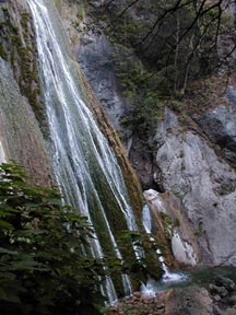
Limekiln State Park Campground sits along the rugged Big Sur coast, offering 29 campsites divided into two distinct environments. Beach sites 1-12 are positioned near the rocky shoreline with ocean views and sounds, while Redwood sites 13-29 are tucked into a lush canyon beneath towering coastal redwoods along Limekiln Creek. Each campsite comes equipped with a metal fire ring, picnic table, and parking for one or two vehicles depending on location. The campground provides hot token-operated showers ($1 for 5 minutes), flush toilets, and potable water distributed throughout the facility. There are no hookups or dump station on-site; the nearest dump station is at Pfeiffer Big Sur State Park. Due to the narrow winding access and compact site layout, vehicle length is limited to 15 feet and RV/trailer length to 24 feet. Beyond camping, the park preserves four historic lime kilns from the 1880s accessible via a short trail. The Limekiln Trail to Pitkins Curve is open, though Hare Creek and Limekiln Falls Trail remain closed. Reservations through ReserveCalifornia are required for all sites, with a 7-night maximum stay during peak season.
Directions
Located 2 miles south of Lucia off Highway 1, approximately 56 miles south of Carmel at mile marker 20.95.
Amenities
| Water | Yes |
| Fires Allowed | Yes |
| Toilets | Yes |
| Dump Station | No |
| Wifi | — |
| Pets Allowed | No |
| Showers | Yes |
| Electric Hookups | — |
| Water Hookups | — |
| Sewer Hookups | — |
| Camp Store | — |
| Price | $50 |
Vehicle
| Max RV Length | 24ft |
| Max Trailer Length | 24ft |
| Big Rig Friendly | No |
| Pull Through Sites | No |
Contact
| Phone | +1 (800) 444-7275 |
Cell Service
| AT&T | None |
| Verizon | None |
| T-Mobile | None |
Availability
Photos


Community Posts
No posts yet. Be the first to share your experience!