Flag Point Lookout
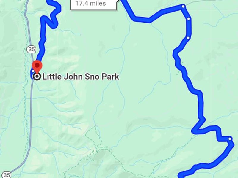
Open for reservations through May 31, 2026. Currently in winter-access mode requiring skiing, snowshoeing, or snowmobiling 10-17 miles from Billybob or Little John Sno-parks. Summer vehicle access typically resumes in late spring after snowmelt; AWD/4WD required. Maximum stay is 7 consecutive nights.
Alcohol Prohibitions
This Order describes acts that are prohibited upon lands, roads and trails within the National Forest System administered by the Forest Service Pacific Northwest Region in regards to alcoholic beverages.
Aquatic Invasive Species
This Order prohibits 1) possessing, storing, or transporting any aquatic invasive animal species AND 2) prohibits possessing, storing, or transporting any aquatic or riparian invasive plant species - on National Forest System lands in the Pacific Northwest Region as specified in the Order.
Restrictions on Use of Forage and Mulch Products
This Order prohibits unloading, storing, or using any straw, hay, grain, seed, or other forage or mulch products that are not state-certified weed free on the National Forest System lands, roads or trails in any Closure Area as specific in the Order. Some examples of these include hay bales, hay…
Fireworks and Explosives are always Prohibited
Fireworks and explosives (including explosive targets) are always prohibited on national forest lands. The prohibition of fireworks and exploding targets on national forest system lands is part of a set of permanent fire safety regulations in the Code of Federal Regulations (CFR), listed below.…
Prescribed burning near Rock Creek Reservoir
Forest wildland fire staff will be conducting a very small prescribed burn near Camp Cody and Rock Creek this week, with post-burn patrol continuing through the weekend. Recent rain and higher relative humidity levels have allowed fire staff to conduct this burn safely before the summer begins.…
Erosion hazards on Pioneer Bridle Trail
Caution: Pioneer Bridle Trail has heavy damage in multiple sections due to erosion from winter storms. Deep ruts could be dangerous for mountain bikers and other users. Bikers should be prepared to dismount for stretches. Trails staff have flagged and signed a particularly dangerous section of…
Tamanawas Falls Trail #650A is CLOSED
Tamanawas Falls Trail #650A is CLOSED due to heavy damage from the December storms. Tamanawas Falls Trail #650A is blocked by multiple slides and completely washed out and destroyed in one section, making Tamanawas Falls inaccessible via that route. The nearby East Fork Trail #650 also has a bridge…
Hazards from Winter Storms
Heavy rains and strong winds created many hazards across Mt. Hood National Forest and surrounding areas during December storms. Although the storms have passed, conditions across the Forest may still be unsafe. Multiple trails and recreation sites across the Clackamas River, Hood River, and Zigzag…
Eagle Creek Fire Area Closures
In 2017, the Eagle Creek Fire caused extensive damage to surrounding areas in Columbia River Gorge and parts of Mt. Hood National Forest. Some trails are closed to the public in both the Gorge and Hood River Ranger District, pursuant to 16 USC § 551 and 36 CFR 261.50 (a) and (b). This closure is…
Health and Safety Closure Due to Roadside Danger Trees
This Order prohibits using any type of motor vehicle upon the following NFS Roads as described: 1) NFS Road 45 (Memaloose Road) from the bridge at highway 224 to the junction with NFS Road 45-310 and 2) NFS Road 54 from the highway 224 junction (at the bridge gate) to NFS Road 5410.
Bull Run Watershed Closure
This Order prohibits 1) Going into or being upon the area which is closed for the protection of public health or safety, 2) Being on a road, 3) Being on a trail within the area described in Exhibit A, except to travel on the Pacific Crest National Scenic Trail #2000 and Huckleberry Trail #617, and…
Camping Stay Restrictions
This Order prohibits 1) Camping in a single location for a period longer than 14 consecutive days and 2) Camping at any location for more than 28 days total during a calendar year on all National Forest System lands as described in this order.
Crane Creek bridge closed on the Barlow Road
The Crane Creek bridge on the Barlow Road (Forest Road 3530) is collapsed and closed. The Barlow Road is open, but it can't be driven from end to end.Crane Creek bridgeLocated approximately 0.4 miles east of the Forest Road 4885-Barlow Road junction.There are temporary barricades and signage…
Sportsman's Park Fire & Occupancy Restrictions
This Forest Order prohibits 1) Building, maintaining, attending or using a fire, campfire, or stove fire and 2) Camping on the Mt. Hood National Forest, Barlow Ranger District; T4S, R11E, Multiple Sections - Sportsman's Park Wildland Urban Interface Zone.
Gordon Creek Watershed Restrictions
This Order prohibits 1) Using a motor vehicle on Forest development roads, except Forest Road 15, which is also known as Larch Mt Road, 2) Using a motor vehicle on Forest development trails, 3) Possessing or using a motor vehicle off Forest development roads, and 4) Camping within the Gordon Creek…
The Dalles Watershed Closure
This Order prohibits visitors from entering or being on the roads or trails of The Dalles Watershed.
About
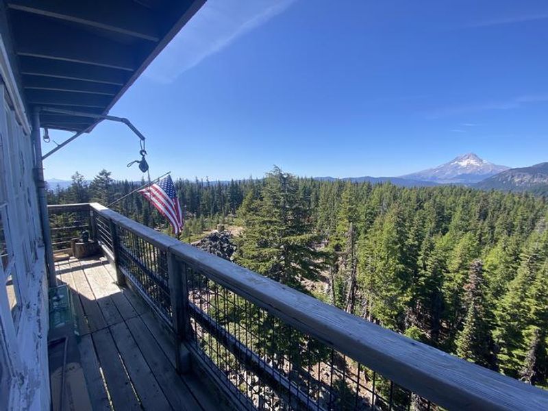
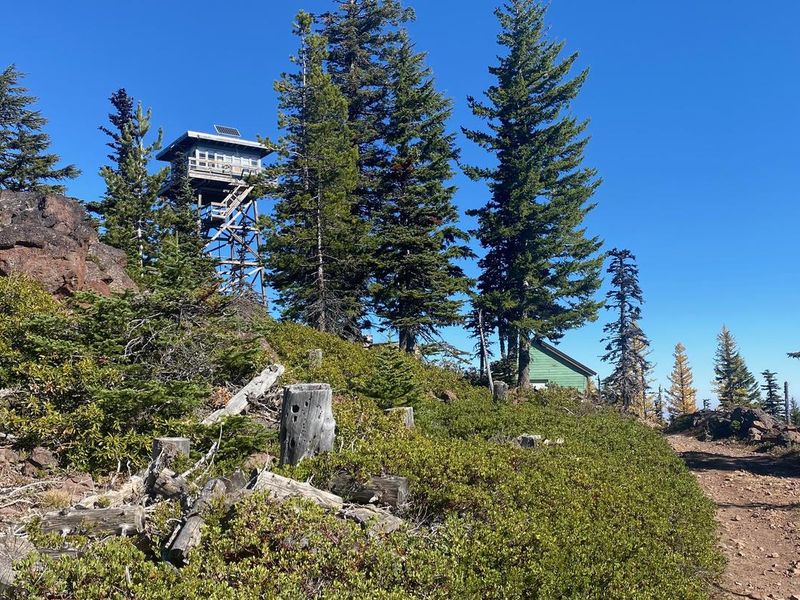
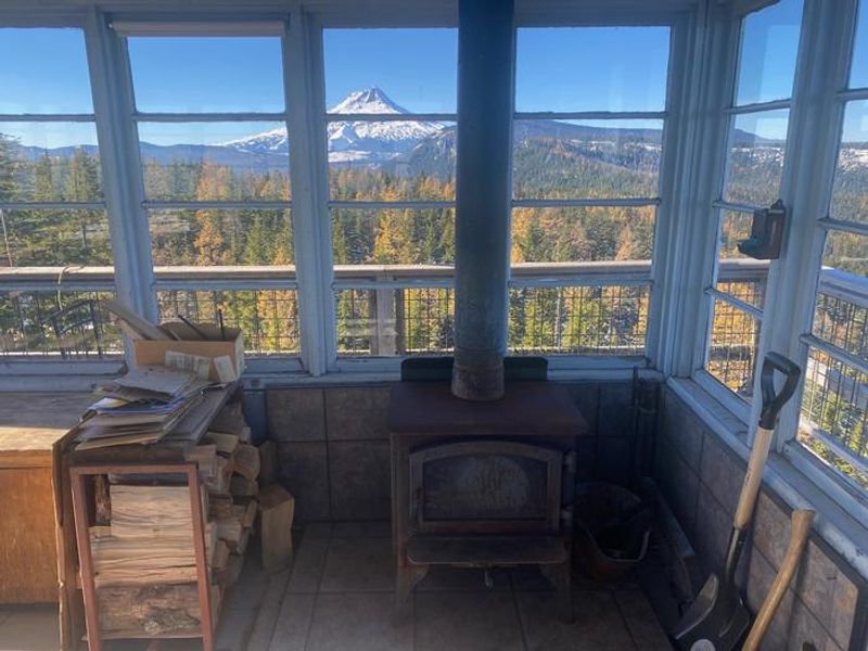
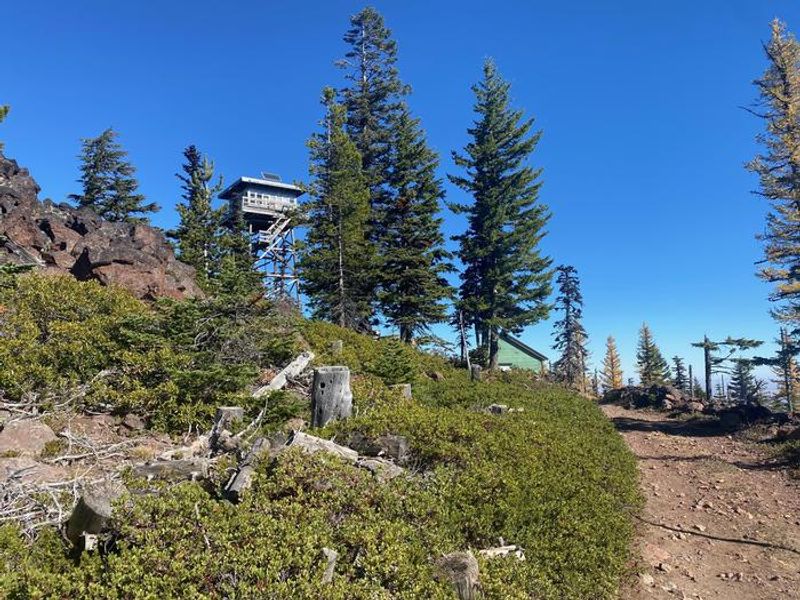
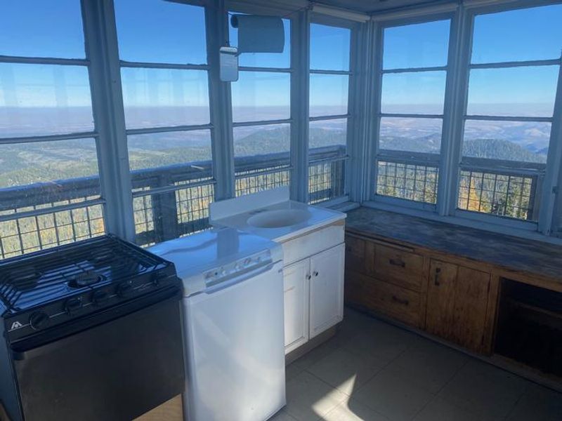
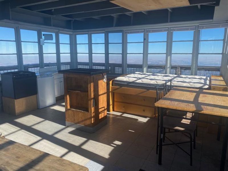
Flag Point Lookout sits at 5,650 feet elevation on Flag Point Butte, surrounded by the Badger Creek Wilderness on the southeast side of Mount Hood. The current structure is a 15x15 foot R-6 Flat Top Style lookout built in 1973, replacing earlier towers dating to 1924. During fire season, Forest Service personnel still use it for fire detection, but from November through May it's available as a unique overnight rental. The 14x14 foot cabin is furnished with a full-size bed, table and chairs, wood heating stove, and propane cook stove with cooking utensils. A shed stocked with firewood sits at the base, and a rope-and-pulley system helps transport gear up the tower. A vault toilet outhouse is located at ground level. No drinking water is available; guests must bring all water for drinking, cooking, and cleaning. Winter access is demanding. The road is closed from December through early April, requiring visitors to ski, snowshoe, or snowmobile 10-17 miles from Billybob or Little John Sno-parks. This is strenuous backcountry travel requiring proper equipment and survival skills. The tower's wooden catwalk and steps become icy and slippery, and the structure may sway in strong winds.
Directions
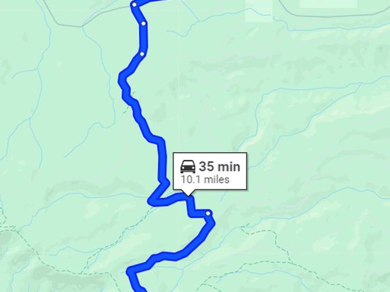
Winter access from Dufur/The Dalles: Take Highway 197 to FS Road 44 (Dufur Valley Road). Follow FS Road 44 west approximately 17 miles to Billybob Sno-Park. Park and follow FS Road 44 west to FS Road 4420 junction, head south to 4420-200, then south to Flag Point Lookout (approximately 11 miles one-way). From Hood River/Portland/Sandy: Take Highway 35 to Little John Sno-Park. Follow Trail 620 to FS Road 44, then to FS Road 4420 and 4420-200 to the lookout (approximately 17 miles). Summer access with AWD/4WD via FS Road 44 to 2730 to 2730-200.
Amenities
| Water | No |
| Fires Allowed | — |
| Toilets | Yes |
| Dump Station | No |
| Wifi | No |
| Pets Allowed | Yes |
| Showers | No |
| Electric Hookups | — |
| Water Hookups | — |
| Sewer Hookups | — |
| Camp Store | No |
| Price | $50 |
Vehicle
| Max RV Length | — |
| Max Trailer Length | — |
| Big Rig Friendly | No |
| Pull Through Sites | No |
Contact
| Phone | +1 (541) 467-2291 |
Cell Service
| AT&T | None |
| Verizon | Yes |
| T-Mobile | None |
Useful Links
| View on Recreation.gov | |
| Mt. Hood NF - Flag Point Lookout |
Availability
Photos
Community Posts
No posts yet. Be the first to share your experience!