Cold Springs - Arapaho Roosevelt Nf
Closed — Closed for the season. Typically operates from late May through mid-September, depending on snow conditions. Reservations available through Recreation.gov.
Wheeled Vehicles in Wilderness
This order describes the prohibition of wheeled vehicles in all National Forest Wilderness Areas of the Rocky Mountain Region and any exceptions thereof.
Weed Free Forage Products
The purpose of this Order is to prevent the introduction or spread of noxious weeds.
Occupancy and Use Restrictions
The purpose of this Order is to protect the public health and safety in the Rocky Mountain Region. This Order is supplemental to and does not rescind or replace those restrictions in 36 C.F.R. Part 261, Subpart A, or any Forest Supervisor Order issued under 36 C.F.R. Part 261, Subpart B.
Cave Closure and Restrictions
The purpose of this Order is to reduce the spread of the fungus that causes White nose syndrome and to protect bat species during critical biological periods.
Fire Restrictions
There are currently no fire restrictions in place on the Arapaho and Roosevelt National Forests and Pawnee National Grassland.
Area Closure Surrounding the Devils Nose Target Range
Safety closure surrounding developed shooting target range.
Permanent Recreational Shooting Order
Permanent recreational shooting order for the Canyon Lakes, Clear Creek, and SulphurRanger Districts of the Arapaho and Roosevelt National Forests and Pawnee NationalGrassland, described in the Forest Order detail below.
Weed Free Forage Products Order
Places restrictions on possessing, storing, or transporting any hay, hay cubes, straw, grain, or other forage or mulch product in the restricted locations
NFS Road 500 Motor Vehicle Prohibition
Prohibits using any type of motor vehicle on the Described Road
Cave Closure and Restrictions
Order is to reduce the spread of the fungus that causes WNS and to protect bat species during critical biological periods
Bear-Resistant Food Storage Required
The purpose of this Order is to reduce the risk of adverse interactions between bears and humans, protecting wildlife and public health and safety
Arapaho and Roosevelt National Forests and Pawnee National Grassland Occupancy and Use
Order covering prohibitions on multiple topics including camping, campfires, dog leash requirements, and more
Forest Camping Stay Limit
Order prohibiting camping for more than 14 days in a 30-day period or more than 30 days in a 365-day period
Winiger Ridge/68J Designated Dispersed Camping Order
Camping, parking, and fire restrictions within the described area, roads, and trails
Rawah, Comanche Peak, Neota, Cache la Poudre Wildernesses Restrictions
Restriction in Rawah, Comanche Peak, Neota, Cache la Poudre Wildernesses
Rainbow Lakes Road and Ceran Saint Vrain No Camping Order
Camping and parking prohibitions within the restricted area
Maxwell Falls and Cub Creek Occupancy and Use Restrictions
Restrictions on occupancy and use in the restricted area
Canyon Lakes and Clear Creek Ranger District Shooting Restrictions
Shooting restrictions for Canyon Lakes and Clear Creek Ranger Districts
Lookout Tower Road Closure
Restrictions on going into or being upon the National Forest System Road and Lands in the Restricted Road/Area
BRD/CLRD Flood Area Closures
The purpose of this Order is to protect public health and safety due to flood damage
Flood Related Shooting Closure
Prohibitions on discharging a firearm, air rifle or gas gun in the Restricted Areas
Barbour Fork/Soda Creek Road
Area closure of a portion of Soda Creek Road and the Barbour Fork Trailhead to dispersed camping, fires and use after sundown or before sunrise
Closure of Portion of Forest System Road 96 (east of Baker Draw Designated Shooting Area)
Prohibits using any type of motor vehicle on the restricted road
West Chicago/Hefferman Gulch - Camping/Fires Closure
Restrictions on camping and campfires in the restricted areas
Road and Area Closure around Baker Draw Designated Shooting Area
Prohibits going into or being upon the Restricted Area and being on the Restricted Roads.
Canyon Lakes Developed Trail Restrictions
Travel restrictions on developed trails in the restricted area
Canyon Lakes Occupancy & Use Restrictions
Restrictions on camping, fires, and boating in the restricted area
South Nederland Shooting Closure
Prohibits discharging a firearm, air rifle or gas gun in the Restricted Area
Pawnee Shooting Closure
Prohibits discharging a firearm, air rifle or gas gun in the restricted area
Motor Vehicle Travel at Loveland & Berthoud Pass Ski Areas
Vehicle restrictions in the restricted area
Motor Vehicle Travel and Developed Trails
Restrictions that apply to motor vehicle travel and developed trail use
Main Off Highway Vehicle (OHV) Area
Prohibited acts in the Main Off Highway Vehicle (OHV) Area within the Pawnee National Grassland
Wheeled Vehicles in Wilderness
Pursuant to 36 CFR, Section 261.50(a) & (b), the following Act is prohibited within all National Forest Wilderness Areas of the Rocky Mountian Region, Forest Service, U. S.
Arapaho National Recreation Area
Occupancy and use restrictions for Arapaho National Recreation Area
Ram’s Horn Closure
Prohibitions on going into or being upon the area commonly known as Ram's Horn between April 1 and July 30, of each year.
Boating Restrictions
Pursuant to 36 CFR, Section 261.50(a) and (b), the following acts are prohibited within the Arapaho and Roosevelt National Forests and Pawnee National Grassland until further notice: 1.
About
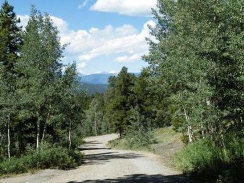
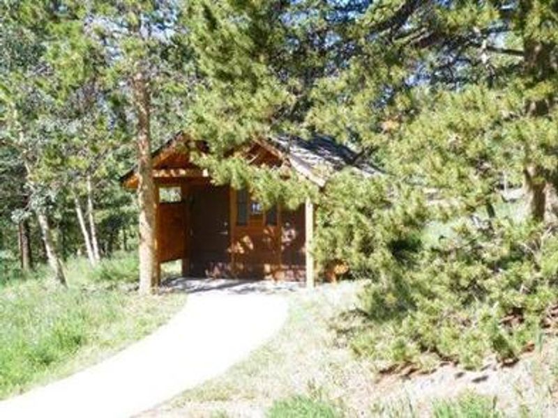
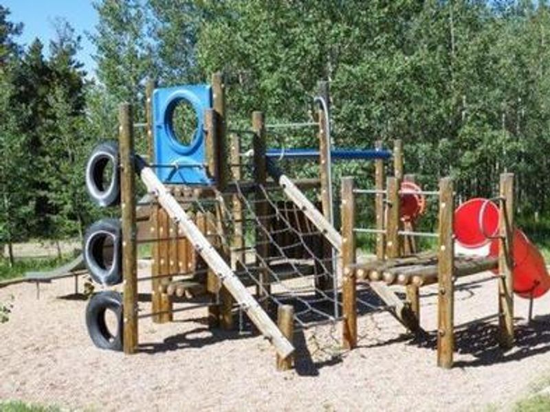
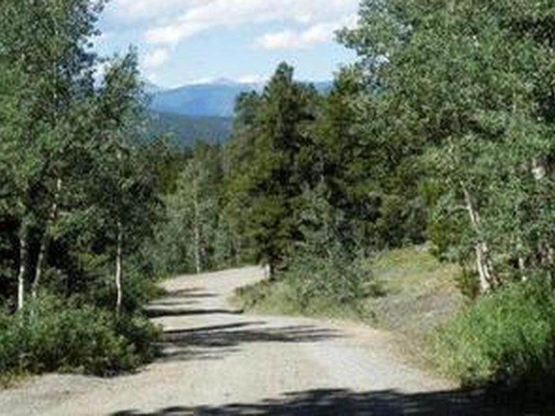
Cold Springs Campground is located on the Arapaho Roosevelt National Forest along the Peak to Peak Scenic Byway (Highway 119), five miles north of the historic mining towns of Black Hawk and Central City. At 9,200 feet elevation, the campground sits within a mountainside forest of aspen and lodgepole pine, offering 38 sites with 31 suitable for RV camping. Each campsite includes a tent pad, picnic table, and fire ring or grate. Sites 1-5, 9, and 10 are pull-over sites with wooden retaining walls that require climbing steps to reach the camping area and are not suitable for RVs with slide-outs. Most sites are shaded, with interior gravel roads and parking spurs ranging from 25 to 50 feet. The campground accommodates RVs up to 40 feet in length. Recreation opportunities include an easy family-friendly hiking trail directly from the campground and the short but steep Vista Trail, which climbs a quarter-mile to spectacular views of the Mount Evans Wilderness Area. The surrounding area offers numerous jeep roads for off-road driving, fishing in nearby creeks, rivers, and lakes, and scenic drives along Highways 119 and 72. Golden Gate Canyon State Park is seven miles away, and the historic mining town of Central City hosts events including the Central City Opera and Jazz festivals.
Directions
From Interstate 25 in Denver, go west on 6th Avenue to State Highway 6 through Clear Creek Canyon. Turn onto State Highway 119 heading toward Black Hawk and Central City. Follow Highway 119 approximately 5 miles north of Black Hawk to the campground on the right.
Nearby Campgrounds
Amenities
| Water | Yes |
| Fires Allowed | Yes |
| Toilets | Yes |
| Dump Station | No |
| Wifi | No |
| Pets Allowed | Yes |
| Showers | No |
| Electric Hookups | No |
| Water Hookups | No |
| Sewer Hookups | No |
| Camp Store | No |
| Price | $27 |
Vehicle
| Max RV Length | 45ft |
| Max Trailer Length | 45ft |
| Big Rig Friendly | Yes |
| Pull Through Sites | No |
Contact
| Phone | +1 (801) 226-3564 |
Cell Service
| AT&T | Yes |
| Verizon | Yes |
| T-Mobile | Yes |
Availability
Photos
Community Posts
No posts yet. Be the first to share your experience!