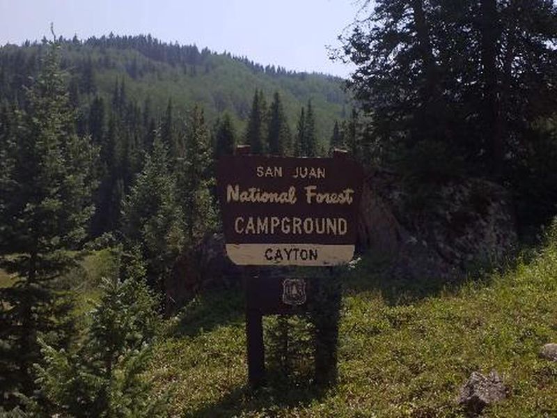
Open

Open for the season through September. Stage 1 fire prohibitions are in effect. Sites are a mix of first-come-first-serve and reservable via Recreation.gov.

Red Flag Warning issued June 11 at 12:17PM MDT until June 12 at 9:00PM MDT by NWS Grand Junction CO

12:17 PM — June 12th, 9:00 AM

* AFFECTED AREA...In Colorado, Fire Weather Zone 200 Little Snake Forecast Area, Fire Weather Zone 202 White River Forecast Area, Fire Weather Zone 290 Paradox Valley Forecast Area, Fire Weather Zone 291 Northern San Juan Forecast Area, Fire Weather Zone 292 North Fork Forecast Area and Fire Weather Zone 294 Southwest Colorado Upper West Forecast Area. In Utah, Fire Weather Zone 486 Eastern Uinta Basin and Fire Weather Zone 487 Book Cliffs. * TIMING...From 1 PM to 9 PM MDT Friday. * WINDS...West 10 to 20 mph with gusts up to 35 mph. * RELATIVE HUMIDITY...7 to 12 percent. * IMPACTS...Fires will catch and spread quickly. Exercise extreme caution with any outdoor burning.

Red Flag Warning issued June 10 at 10:02PM MDT until June 10 at 10:00PM MDT by NWS Grand Junction CO

June 10th, 10:02 PM — 1:45 PM

* AFFECTED AREA...In Colorado, Fire Weather Zone 200 Little Snake Forecast Area, Fire Weather Zone 202 White River Forecast Area, Fire Weather Zone 203 Lower Colorado River, Fire Weather Zone 205 Colorado River Headwaters, Fire Weather Zone 290 Paradox Valley Forecast Area, Fire Weather Zone 291 Northern San Juan Forecast Area, Fire Weather Zone 292 North Fork Forecast Area and Fire Weather Zone 294 Southwest Colorado Upper West Forecast Area. In Utah, Fire Weather Zone 487 Book Cliffs. * TIMING...From Friday morning through Friday evening. * WINDS...Northwest 10 to 20 mph with gusts up to 45 mph. * RELATIVE HUMIDITY...6 to 11 percent. * IMPACTS...Fires will catch and spread quickly. Exercise extreme caution with any outdoor burning.

Wheeled Vehicles in Wilderness

This order describes the prohibition of wheeled vehicles in all National Forest Wilderness Areas of the Rocky Mountain Region and any exceptions thereof.

Weed Free Forage Products

The purpose of this Order is to prevent the introduction or spread of noxious weeds.

Cave Closure and Restrictions

The purpose of this Order is to reduce the spread of the fungus that causes White nose syndrome and to protect bat species during critical biological periods.

STAGE 1 FIRE PROHIBITIONS

Stage 1 Fire Restrictions are in effect as of Jun 12th, 2026 for the entire San Juan National Forest.

Cottonwood Road Reconstruction Area Closure Order

The Cottonwood Road (NFSR 532) on the Dolores Ranger District will be closed from mile marker 3.7 to 4.6 and the Mavreeso Trailhead will be closed at the Cottonwood Road (southern terminus of the trail)

STAGE 1 FIRE PROHIBITIONS

Stage 1 Fire Restrictions are in effect as of 5/22/2026 for the San Juan National Forest. Areas affected are shown in the attached maps. This order will be rescinded and replaced by a new, full-forest Stage 1 Fire Restrictions order on 6/12/2026.

Falls Creek Closure Area, Camping, and Motor Vehicle Travel Restrictions

This San Juan National Forest forest order describes closure areas, as well as camping and motor vehicle travel restrictions in the Falls Creek.

West Fork Road and Bridge Closure Order

The Pagosa Ranger District's West Fork Bridge is closed by Forest Order due to damage during the October 2025 flood events. Forest Road 648 (West Fork) is closed at location identified by this order.

Multiple roads and trails damaged by flooding on SJNF

In early October, severe flooding events created ongoing safety and access concerns for Forest users on the Columbine and Pagosa Ranger Districts of the San Juan National Forest. Available forest employees are assessing the many roads, trails, bridges, and other infrastructure that was damaged or…

Lemon Reservoir Restrictions

The following act is prohibited on the National Forest System (NFS) lands and waters on the Columbine Ranger District of the San Juan National Forest:

Cascade Flume Safety Closure

Area closure: The purpose of this Order is for public health and safety during the Cascade Tacoma Flume repair. The recent failure of the flume resulted in infrastructure damage and a landslide that has destabilized the Described Area. Concerns for public safety include loose debris, continuing…

McPhee Reservoir Prohibitions

The purpose of this Order is to prevent the infestation of aquatic nuisance species.

Mancos/Dolores Camping Restrictions

The purpose of this Order is to protect public safety and natural resources.

Purgatory Ski Resort Area Vehicle Use Restrictions

From November 15 through April 30 annually, it is prohibited to use an over-snow vehicle (snowmobiles, timber sleds, and ski bikes) or mechanized vehicle that lacks a motor, such as a non-electric bicycle, on the Described Roads and Described Trails and OFF NFS roads in the Described Area. (See map…

Chicken Creek Ski Area Dog Restrictions

Dogs are not allowed in the Chicken Creek Ski Area from December 15 to March 15, annually in order to protect public safety.

McPhee Overlook Trail Seasonal Closure

The purpose of the seasonal closure of the McPhee Over Trail is to protect critical winter wildlife habitat.

Andrews Lake Camping Restrictions

Andrews Lake area is closed to camping in order to protect natural resources.

La Plata Canyon Camping and Fire Restrictions

La Plata Canyon Camping and Fire Restrictions are in place to protect the natural resources in this beautiful, very popular area. Camping is prohibited outside of Forest Service designated camping areas (Darby, La Plata City, Bay City, Miners Cabin, and Madden Creek) and developed campgrounds…

Hermosa Creek Wilderness Occupancy and Use Restrictions

In order to protect the National Forest System (NFS) lands and trails in the Hermosa Creek Wilderness, the following are prohibited:Entering or being upon a trail, campsite, or other area by a group larger than 15 people, with a maximum combination of people and stock not to exceed 25 in one…

Forest Wide Camping Stay Limits

In order to protect natural resources and to provide for public health and safety, the following are prohibited on National Forest System (NFS) lands in the San Juan National Forest:Camping, or leaving camping equipment at any location or within three (3) miles of any prior…

Chimney Rock National Monument Occupancy and Use Restrictions

The purpose of this Order is to protect the objects of the monument through implementing restrictions prescribed in the Chimney Rock National Monument (CRNM) Final Management Plan and Environmental Impact Statement (EIS).

Grizzly Peak Research Natural Area Special Closure Order

This order implements prohibitions necessary to provide protection of natural conditions and processes in order to facilitate research and education and maintain biological diversity – the purposes for which RNAs are established on National Forest System lands – within the Grizzly Peak RNA.

Lizard Head Wilderness Area Occupancy & Use

This Order is necessary to protect physical and biological resources of the Lizard Head Wilderness, and to protect the human experience of Wilderness character, solitude, and the untrammeled condition of the landscape.

Forest Orders

Visit our Forest Order page for a list of all the current Forest Orders: Closures, Fire Restrictions, and Camping, Occupancy, and Use Restrictions.Forest and Regional orders are generally temporary in nature and are designed to protect public safety and our natural resource. After review, Regional…

About

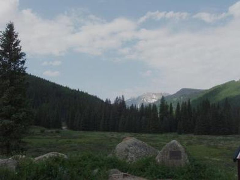
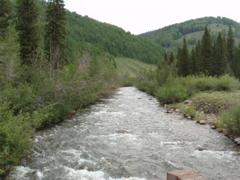
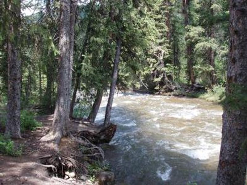
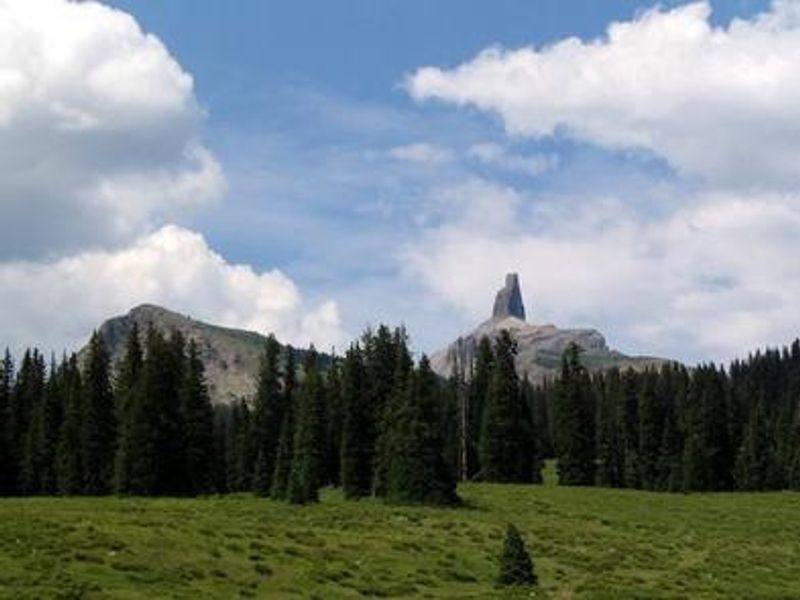
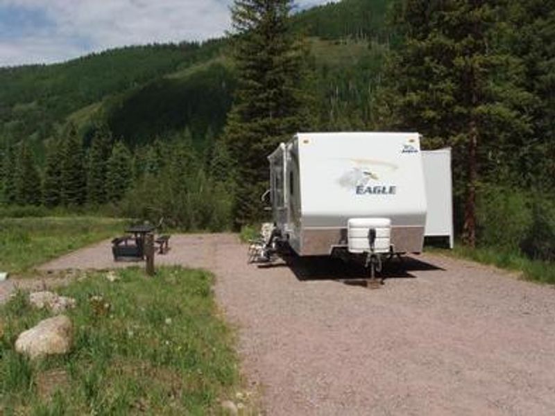
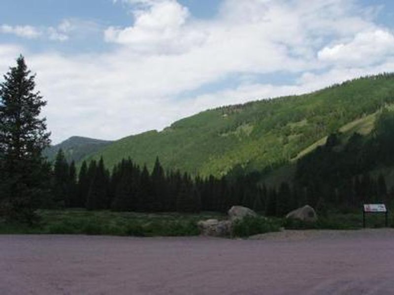
Cayton Campground is located along the San Juan Skyway (Colorado Highway 145) and the Dolores River, 6 miles northeast of Rico. The campground occupies a grassy meadow surrounded by fir and aspen trees at 9,400 feet elevation, so expect cool evenings even in summer. The 27 single-family campsites include 16 reservable sites and 11 first-come-first-serve sites, with 16 sites offering 30-amp electric hookups. The Dolores River provides excellent fishing for rainbow, brown, and cutthroat trout, though weekends can be crowded. Barlow Creek Road continues past the campground and crosses Bolam Pass with spectacular views, eventually connecting to Hermosa Park Road and US Highway 550. The Colorado Trail follows the ridge across Bolam Pass. Nearby Lizard Head and Cross Mountain Trails lead to alpine basins surrounded by 14,000-foot peaks. Each site includes a picnic table and fire ring. The campground has four vault toilets, potable drinking water, and a dump station. Pull-through sites accommodate RVs up to 50 feet. Four sites (5, 6, 10, and 25) meet accessibility standards. Quiet hours are 10pm to 6am, and generators should be limited to one hour at a time.

Directions

From Rico, travel 6 miles northeast on Colorado Highway 145. Turn right (east) on Forest Road 578 (Barlow Creek Road). The campground entrance is a half-mile further.

Amenities

Water Yes
Fires Allowed Yes
Toilets Yes
Dump Station Yes
Wifi No
Pets Allowed Yes
Showers No
Electric Hookups Yes
Water Hookups No
Sewer Hookups No
Camp Store No
Price $30 - $41

Vehicle

Max RV Length 70ft
Max Trailer Length 70ft
Big Rig Friendly Yes
Pull Through Sites No

Contact

Phone +1 (661) 702-1420

Cell Service

AT&T None
Verizon None
T-Mobile None

Availability

Photos

SAN JUAN - CAYTON CAMPGROUND

Community Posts

No posts yet. Be the first to share your experience!