Cranberry Campground
Open from early April through end of November. First-come, first-served only with no advance reservations. Maximum stay is 14 days. High demand during trout stocking season (spring through June, September through October) often results in more campers than available sites.
Flash Flood Warning issued September 22 at 5:30PM EDT until September 22 at 8:30PM EDT by NWS Charleston WV
FFWRLX The National Weather Service in Charleston has issued a * Flash Flood Warning for... Eastern Braxton County in north central West Virginia... West Central Randolph County in northeastern West Virginia... Upshur County in northeastern West Virginia... Northern Webster County in northeastern West Virginia... Southeastern Lewis County in northern West Virginia... * Until 830 PM EDT. * At 530 PM EDT, Doppler radar indicated thunderstorms producing heavy rain across the warned area. Between 1 and 3 inches of rain have fallen. Flash flooding is ongoing or expected to begin shortly. HAZARD...Flash flooding caused by thunderstorms. SOURCE...Radar indicated. IMPACT...Flash flooding of small creeks and streams, urban areas, highways, streets and underpasses as well as other poor drainage and low-lying areas. * Some locations that will experience flash flooding include... Buckhannon, Rock Cave, Holly River State Park, Burnsville, Flatwoods, Kanawha Head, Eden, Cleveland, Ireland, Walkersville, French Creek, Alexander, Hacker Valley, Alton, Falls Mills, Helvetia, Horner, Lorentz, Tallmansville and Diana. This includes the following highways... Interstate 79 between mile markers 73 and 81...and between mile markers 86 and 87. Route 33 between mile markers 2 and 7...and between mile markers 15 and 17. This includes the following streams and drainages... Hughes Fork, Jerry Run, Laurel Fork Sand Run, Left Fork Buckhannon River, Desert Fork, Falls Run, Jenks Fork, Long Run, Left Fork Falls Run, Marsh Fork, Devil Fork, O'Brien Fork, Hackers Creek, Getout Run, See Shanty Run, Wheeler Fork, Lynn Camp Run, Wolfpen Run, Redlick Run, Hodam Creek, Pecks Run, Browns Run, Buffalo Run, Middle Fork Right Fork Buckhannon River, Little Knawl Creek, West Fork River, Elk Creek, Rooting Creek, Fink Run, Elk River, West Fork River (SJ Lake), Sugar Run, Grassy Creek, Indian Fork, Laural Run, Spruce Fork, Birch River, Bluelick Run, Tenmile Creek, Big Run, Left Fork Sand Run, Hickory Flat Run, French Creek, Middle Fork River, Salt Lick Creek, Little Sand Run, Cherry Fork, Carpenter Fork, Honey Camp Run, Sand Fork, Saltlick Creek, Brooks Creek, Hyers Run, Burns Run, Dumpling Run, Right Fork Holly River, Bragg Run, Skin Creek, Stouts Run, Right Fork Stonecoal Creek, Grassy Run, Berry Fork, Bearcamp Run, Little Skin Creek, Turkey Run, Right Fork Middle Fork River, Mud Lick, Brook Run, Howell Fork, Straight Fork, Right Fork Little Kanawha River, Right Fork West Fork River, Laurel Run, Sand Run, Little Pecks Run, Oil Creek, Flesher Run, Stonecoal Creek, Missouri Creek, Lost Run, Little Laurel Fork, Little Kanawha River, Laurel Fork, Lower Big Run, Frog Run, Left Fork Right Fork Buckhannon River, Left Fork Holly River, Bens Run, Kanawha Run, Threelick Run, Right Fork Little Kanawha, Cedar Creek, Right Fork Laurel Fork, Log Hollow Run, Millsite Run, Grass Run, Buckhannon River, Bridge Run, Brush Run, Slab Camp Fork, Sugarcamp Run, Laurel Creek, Short Run, Knawl Creek, England Run, Right Fork Buckhannon River, Left Fork Wolf Creek, Left Fork Knawl Creek, Three Forks Run and McAvoy Run.
Flood Watch issued September 22 at 1:12PM EDT until September 23 at 8:00PM EDT by NWS Charleston WV
* WHAT...Flash flooding caused by excessive rainfall continues to be possible. * WHERE...Portions of southeast Ohio, including the following county, Washington and West Virginia, including the following counties, Barbour, Boone, Braxton, Cabell, Calhoun, Clay, Doddridge, Gilmer, Harrison, Jackson WV, Kanawha, Lewis, Lincoln, Logan, Mason, McDowell, Mingo, Northwest Fayette, Northwest Nicholas, Northwest Pocahontas, Northwest Raleigh, Northwest Randolph, Northwest Webster, Pleasants, Putnam, Ritchie, Roane, Southeast Fayette, Southeast Nicholas, Southeast Pocahontas, Southeast Raleigh, Southeast Randolph, Southeast Webster, Taylor, Tyler, Upshur, Wayne, Wirt, Wood and Wyoming. * WHEN...Through Wednesday evening. * IMPACTS...Excessive runoff may result in flooding of rivers, creeks, streams, and other low-lying and flood-prone locations. * ADDITIONAL DETAILS... - Slow moving heavy showers and thunderstorms will periodically move through the area through Wednesday. Areas which have previously received heavy rain will be most vulnerable to additional flooding. - http://www.weather.gov/safety/flood
Interagency Passes
Interagency Passes are available for purchase at our Welcome Center Monday through Saturday between the hours of 8:00am and 4:30pm. We recommend calling our front desk at 815-423-6370 prior to your arrival to make sure a qualified staff member is present to distribute passes.Our Welcome Center…
About
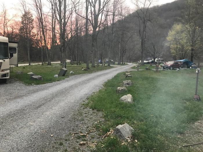
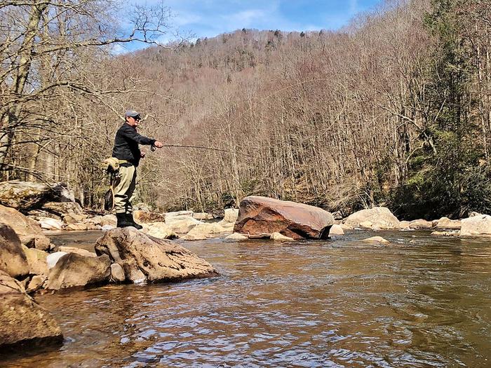
Cranberry Campground is a popular semi-primitive campground in the Gauley Ranger District of Monongahela National Forest, situated adjacent to the Cranberry River and serving as the lower-gate entrance to the Cranberry Backcountry. The campground features 28 single sites and 2 double sites arranged in two loops, each equipped with a picnic table, fire ring, lantern post, and gravel parking spur. Facilities include four accessible vault toilets and two hand pumps providing potable water. Most sites can accommodate trailers up to 40 feet. The campground operates on a first-come, first-served basis with no advance reservations. Single sites cost $10 per night and double sites $20 per night, with a maximum stay of 14 days. The adjacent Cranberry River offers excellent trout fishing, which drives heavy use during stocking seasons from early spring through June and again September through October. During peak periods, demand often exceeds available sites. Nearby Bishop Knob Campground can accommodate overflow campers when Cranberry is full.
Directions
From Richwood: Travel 1 mile east on State Route 39/55, then 12.5 miles north on Forest Road 76. From Dyer on State Route 46: Take Forest Road 101 approximately 6 miles, then turn left onto Forest Road 76 for 1 mile.
Amenities
| Water | Yes |
| Fires Allowed | Yes |
| Toilets | Yes |
| Dump Station | No |
| Wifi | No |
| Pets Allowed | Yes |
| Showers | No |
| Electric Hookups | — |
| Water Hookups | — |
| Sewer Hookups | — |
| Camp Store | No |
| Price | $10 - $20 |
Vehicle
| Max RV Length | — |
| Max Trailer Length | 40ft |
| Big Rig Friendly | Yes |
| Pull Through Sites | — |
Contact
| Phone | +1 (304) 846-2695 |
Cell Service
| AT&T | None |
| Verizon | None |
| T-Mobile | None |
Photos

Community Posts
No posts yet. Be the first to share your experience!