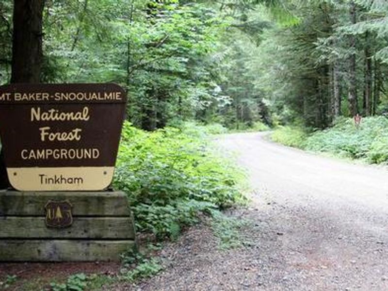
**DETOUR:** Due to road work occurring on Tinkham Road 0.25 miles west of Tinkham Campground, **all visitors arriving between May 15th through May 22nd should plan to use 1-90 Exit 47 to access this facility.** Please avoid using Exit 42 during this period. We apologize for any inconvenience this may cause.
Mount Baker-Snoqualmie National Forest
This Order describes acts that are prohibited upon lands, roads and trails within the National Forest System administered by the Forest Service Pacific Northwest Region in regards to alcoholic beverages.
Mount Baker-Snoqualmie National Forest
This Order prohibits 1) possessing, storing, or transporting any aquatic invasive animal species AND 2) prohibits possessing, storing, or transporting any aquatic or riparian invasive plant species - on National Forest System lands in the Pacific Northwest Region as specified in the Order.
Mount Baker-Snoqualmie National Forest
This Order prohibits unloading, storing, or using any straw, hay, grain, seed, or other forage or mulch products that are not state-certified weed free on the National Forest System lands, roads or trails in any Closure Area as specific in the Order. Some examples of these include hay bales, hay…
Mount Baker-Snoqualmie National Forest
Fireworks and explosives (including explosive targets) are always prohibited on national forest lands. The prohibition of fireworks and exploding targets on national forest system lands is part of a set of permanent fire safety regulations in the Code of Federal Regulations (CFR), listed below.…
Mount Baker-Snoqualmie National Forest
The Pratt River Trail 1035 is closed 07/23/2026 - 07/25/2026 for trail work. The closure starts at intersection with the Middle Fork Trail 1003 and extends for two miles.
Mount Baker-Snoqualmie National Forest
Mountain goat populations have been declining in recent years. Please help by keeping your distance. This will avoid disturbance to the goats and keep them in the habitat they need to survive. Injuries and even deaths have occurred to humans by mountain goats:Keep pets on leash! Always stay 50…
Mount Baker-Snoqualmie National Forest
Forest Service Road 1540 is closed due to a wash-out at Mile Post 2.6. Hidden Lake Trailhead is inaccessible by vehicle. Sibley Creek Road/FSR 1540 is off of the Cascade River Road near Marblemount, WA.
Mount Baker-Snoqualmie National Forest
Winter weather conditions resulted in damage to roads across the Mt. Baker-Snoqualmie National Forest (MBS). The MBS will undertake repairs on several roads this summer and next to address road damage. On the I-90 and Middle Fork Snoqualmie corridors of the Snoqualmie Ranger District, the following…
Mount Baker-Snoqualmie National Forest
Glacier Creek Road (FSR 39) will be closed to all vehicles at Glacier Creek bridge at MP 3.0 to the Heliotrope Ridge Trailhead for scheduled road repairs. The road will remain open to Pedestrians, Bikes, And eBikes at Forest Service Engineer and Contractor discretion.
Mount Baker-Snoqualmie National Forest
Beginning in late August (between 08/10 and 08/24), Forest Service Roads 12 (and 1230) will be closed for scheduled road repairs. FSR 12 will be closed to vehicle traffic from Rocky Creek Bridge (MP 4.6) through to the Pioneer Camp and Dock Butte/Blue Lake Trailheads. The roads will remain open to…
Mount Baker-Snoqualmie National Forest
Beginning around July 15, Baker Lake Road (Forest Service Road 11) will be closed to all vehicle and foot traffic at the Shannon Creek Bridge (approximately MP 23.8), through its terminus at Baker River Trailhead. Baker Lake Trail (610) access will be only from the Baker Lake (South) Trailhead off…
Mount Baker-Snoqualmie National Forest
Winter weather conditions resulted in damages and closures to roads across the Mt. Baker-Snoqualmie National Forest (MBS). The MBS will undertake repairs on several roads this summer and next to address road damage. On the Skykomish District, affected roads include:FSR 63 (Index Galena Road)…
Mount Baker-Snoqualmie National Forest
Winter weather conditions resulted in damage to roads across the Mt. Baker-Snoqualmie National Forest (MBS). The MBS will undertake repairs on several roads this summer and next to address road damage. On the Highway 410 corridor of the Snoqualmie Ranger District, the affected roads include:FSR…
Mount Baker-Snoqualmie National Forest
The Mallardy Road (Forest Service Road 4032) is closed for public safety during summer timber operations. The road closure is from the intersection with Forest Service Road 4030 to the road's end at Mallardy Ridge Trailhead.
Mount Baker-Snoqualmie National Forest
The bridge decking on the Baker River stock and pedestrian bridge at the north end of Baker Lake needs to be replaced to meet stock safety standards. Work on the bridge will be ongoing through August. The bridge is closed to stock. Pedestrians can still cross the bridge, but there may be delays on…
Mount Baker-Snoqualmie National Forest
Forest Service Road 37 Deadhorse Creek Road flood damage repair is underway. For public safety due to heavy equipment use the road will be closed at mile 0.03 until further notice.
Mount Baker-Snoqualmie National Forest
Forest Service News Release Firewood permits now available for online purchase (Everett, WA, May 20, 2026) — Firewood permits on the Mount Baker-Snoqualmie National Forest are now available through a new online e-Permit system. This option allows users to obtain permits from a computer or…
Mount Baker-Snoqualmie National Forest
Visitors accessing Foss River Road (Forest Service Road 68) should expect 30-minute delays beginning May 4 through September. Road construction will be on week days between 6:00 a.m. and 8:00 pm. For further information, contact the Skykomish Ranger Station.
Mount Baker-Snoqualmie National Forest
The Suiattle River Road (FSR 26) and other roads within the watershed were severely damaged from an atmospheric river flood event. The Suiattle River Road (at milepost 4) and associated spur roads are closed for public safety.
Mount Baker-Snoqualmie National Forest
The Fairfax Bridge on State Highway 165 (milepost 11.5) across the Carbon River has been permanently closed by Washington Department of Transportation (DOT) due to safety concerns. The bridge closure prevents vehicle access to Forest Road 7810, Summit Lake Trailhead, Coplay Lake, and Evans Creek…
Mount Baker-Snoqualmie National Forest
Road damage caused by the December floods, along with their proximity to the river, makes public access unsafe. A temporary closure has been established on Forest Service Road #23 (White Chuck Road) from milepost 3.7 to its terminus with Forest Service Road #27 (Rat Trap Pass Road) and on Forest…
Mount Baker-Snoqualmie National Forest
Dispersed camping is prohibited along part of Forest Road 56 and 5640, in a corridor adjacent to the Wild and Scenic Middle Fork Snoqualmie River. The purpose of the camping restriction is to reduce recreation-related impacts to: 1) riparian areas and 2) the recreation experience for day-use…
Mount Baker-Snoqualmie National Forest
This order sets limits on how long people can camp in one place to protect natural resources, protect visitor health, and ensure all visitors have a fair chance to use camping areas and available facilities. You can camp no more than 14 days in a row at the same spot outside developed…
Mount Baker-Snoqualmie National Forest
The Mt. Baker-Snoqualmie National Forest has a food storage order in effect across the entire Forest. This order requires visitors to the Mt. Baker-Snoqualmie National Forest to store food items in a “bear resistant manner” and to properly dispose of wildlife attractants. The food storage…