Timberlane Campground
Closed for the entire 2026 season for maintenance. Typically open May 15 through September 10. Reservations via Recreation.gov.
Northern Region Camping & Target Restrictions, Pallet Prohibition
This order defines the maximum length of occupation at a single location or cumulatively at any number of locations within a calendar year, within the states of Montana, North Dakota, South Dakota, and Idaho
Weed Free Forage & Mulch Products Order for the Northern Region
It is illegal to possess, store or transport straw, hay, grain, seed or other forage or mulch products on Forest Service lands without documentation that the product is certified as “weed free” by a state certification process that meets or exceeds the North American Weed Free Forage standards.
R1-2023-02 - NCDE Food and Wildlife Attractant Storage Order
Northern Continental Divide Ecosystem Food/Wildlife Attractant Storage Order for the Flathead, Lolo, Kootenai, Helena-Lewis and Clark, and Beaverhead-Deerlodge National Forests within the Northern Continental Divide Ecosystem.
Trail Advisory-Alexander Mountain Trail near Timber Harvest Activities
Please use caution and watch for timber harvest activity if utilizing the Alexander Mountain Trail #270 off the FDR Road #228 on the Libby Ranger District. A small portion of the trail passes through a section of the Fleetwood Jack Timber Sale, that has ongoing operations. The trail will remain…
St. Paul Lake Trailhead-No Camping Closure Order
A closure order is now in effect prohibiting camping in the surrounding area of the St. Paul Lake Trailhead on the Cabinet Ranger District. The purpose is to protect bull trout, resource values, public health and safety at the trailhead and maintaining access to the St. Paul Lake Trail #646. The…
Ross Creek Cedars Road Closure & Storm Damage Update
The Ross Creek Cedars sustained significant damage during the December 2025 flood events. Heavy rains, flooding, landslide, and debris flows that occurred in December 2025 created unstable conditions along NFS Road #398. Significant erosion undercut sections of the road, limiting access to foot and…
Rexford Bench Boat Launch Closure
Construction operations are now complete on the Rexford Bench boat launch upgrade and it is now open. The boat launch was closed while the existing asphalt was replaced with concrete. The low water ramp is available but due to the low level of the reservoir, please be aware of muddy conditions…
Big Creek Closure-Peregrine Falcon Nesting Area
A closure order is in now effect for the Big Creek Area on the Rexford Ranger District, which is a known area for peregrine falcon nesting. Peregrine falcons are particularly sensitive to disturbance and activity above their nest or rock climbing in its vicinity. Disturbance during the nesting…
Timberlane Campground Closure
A closure order is now in effect for the Timberlane Campground on the Libby Ranger District, while it undergoes much-needed improvements. The purpose of this order is for public safety during reconstruction and improvement operations in the campgroundAs you start making your summer plans and…
Spar Lake Road #384 Road Closed to Motorized Vehicles
A closure order is now in effect for motorized vehicles on the Three Rivers Ranger District for Forest Service Road #384 (Spar Lake). The closure is to provide for public safety until crews make appropriate repairs to road damage caused by the December 2025 flood event. The road is closed starting…
Upper Young Creek Road #7202 Closure
A closure order is now in effect on the Rexford Ranger District for Forest Service Road #7202 (Upper Young Creek Road). The closure is to provide for public safety due to a washout making the road impassable. The road is currently closed at milepost 3.5 to 3.6, just north of its junction with NFS…
Kootenai Flood Event & Inaccessible Areas
Portions of the Kootenai National Forest have recently experienced heavy amounts of rainfall due to an atmospheric river moving through the area. The rapid increase in rainfall on top of snow in the higher elevations has resulted in localized flooding and increased the risk of landslides, debris…
About
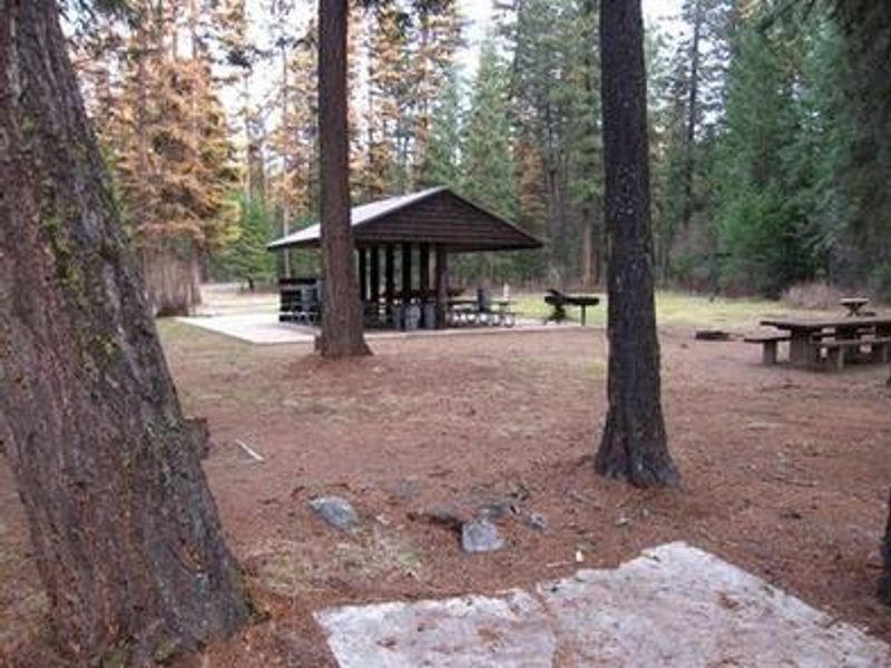
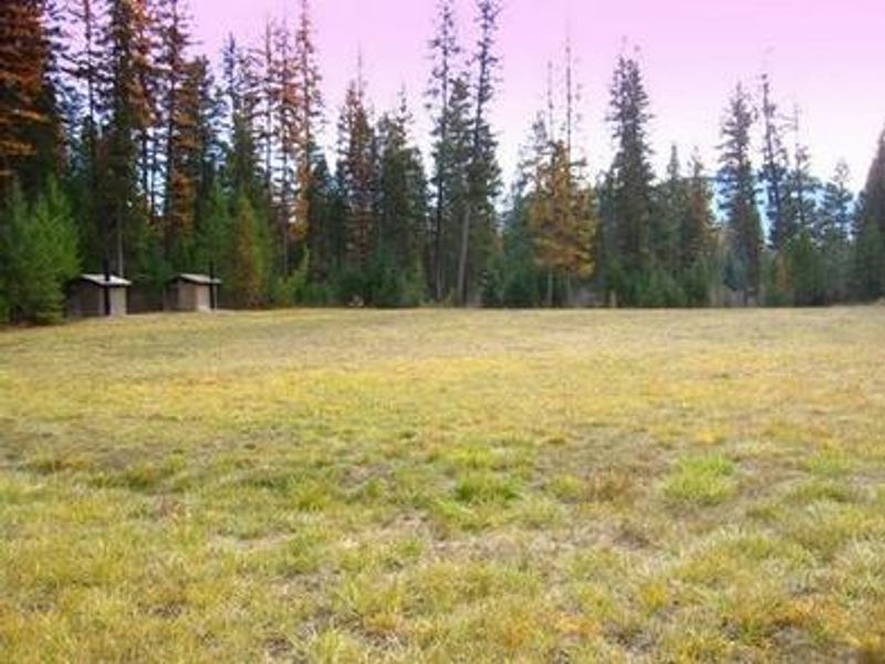
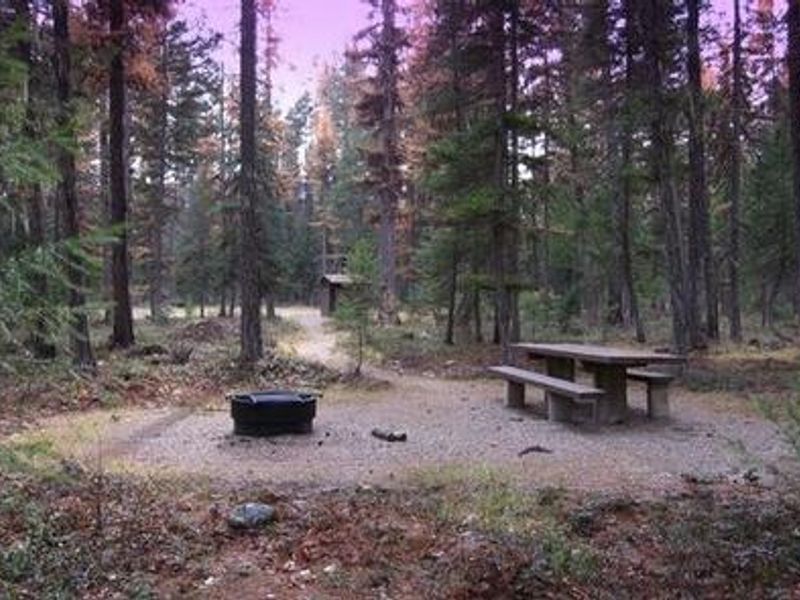
Timberlane Campground is located along Pipe Creek in the Kootenai National Forest of northwestern Montana, surrounded by towering mixed conifers at approximately 2,600 feet elevation. The campground offers nearly a dozen single-family campsites, each equipped with a picnic table and campfire ring with grill. A 20x20 group pavilion with picnic tables and a 15-amp electrical receptacle accommodates gatherings of up to 200 people. Recreational opportunities abound with horseshoe pits, a volleyball court, and a large grassy play field on site. A 1-mile hiking trail encircles the campground, and Pipe Creek provides access to fishing and swimming. The area holds historical significance as a former habitat and hunting ground for the Kootenai Tribe, including a location where soft, multicolored stone was carved into ceremonial tobacco pipes. Nearby attractions include the David Thompson Historic Route, the 67-mile Lake Koocanusa Scenic Byway, and the Scenic Tour of the Kootenai River bike route. The town of Libby is nearby, making Timberlane a convenient base for events like Logger Days and Nordicfest.
Directions
From Libby, Montana, cross the Kootenai River Bridge on Highway 37, go approximately 1 mile and turn north onto Pipe Creek Road 68. Travel 8 miles to the gate, approximately 1 mile past the community of Pipe Creek.
Amenities
| Water | No |
| Fires Allowed | Yes |
| Toilets | Yes |
| Dump Station | — |
| Wifi | — |
| Pets Allowed | Yes |
| Showers | — |
| Electric Hookups | Yes |
| Water Hookups | No |
| Sewer Hookups | No |
| Camp Store | — |
| Price | $75 - $150 |
Vehicle
| Max RV Length | 30ft |
| Max Trailer Length | — |
| Big Rig Friendly | — |
| Pull Through Sites | No |
Contact
| Phone | +1 (406) 293-7773 |
Cell Service
| AT&T | None |
| Verizon | None |
| T-Mobile | None |
Availability
Photos
Community Posts
No posts yet. Be the first to share your experience!