Overlooking Granite Peaks Ranch, Yaks grazing in meadow.
Open

Open for the season. Operating late May through September on a first-come, first-served basis. No advance reservations; payment on-site via Recreation.gov mobile app Scan and Pay feature. No potable water available.

Wheeled Vehicles in Wilderness

This order describes the prohibition of wheeled vehicles in all National Forest Wilderness Areas of the Rocky Mountain Region and any exceptions thereof.

Weed Free Forage Products

The purpose of this Order is to prevent the introduction or spread of noxious weeds.

Cave Closure and Restrictions

The purpose of this Order is to reduce the spread of the fungus that causes White nose syndrome and to protect bat species during critical biological periods.

STAGE 1 FIRE PROHIBITIONS

Stage 1 Fire Restrictions are in effect as of Jun 12th, 2026 for the entire San Juan National Forest.

Cottonwood Road Reconstruction Area Closure Order

The Cottonwood Road (NFSR 532) on the Dolores Ranger District will be closed from mile marker 3.7 to 4.6 and the Mavreeso Trailhead will be closed at the Cottonwood Road (southern terminus of the trail)

STAGE 1 FIRE PROHIBITIONS

Stage 1 Fire Restrictions are in effect as of 5/22/2026 for the San Juan National Forest. Areas affected are shown in the attached maps. This order will be rescinded and replaced by a new, full-forest Stage 1 Fire Restrictions order on 6/12/2026.

Falls Creek Closure Area, Camping, and Motor Vehicle Travel Restrictions

This San Juan National Forest forest order describes closure areas, as well as camping and motor vehicle travel restrictions in the Falls Creek.

West Fork Road and Bridge Closure Order

The Pagosa Ranger District's West Fork Bridge is closed by Forest Order due to damage during the October 2025 flood events. Forest Road 648 (West Fork) is closed at location identified by this order.

Multiple roads and trails damaged by flooding on SJNF

In early October, severe flooding events created ongoing safety and access concerns for Forest users on the Columbine and Pagosa Ranger Districts of the San Juan National Forest. Available forest employees are assessing the many roads, trails, bridges, and other infrastructure that was damaged or…

Lemon Reservoir Restrictions

The following act is prohibited on the National Forest System (NFS) lands and waters on the Columbine Ranger District of the San Juan National Forest:

Cascade Flume Safety Closure

Area closure: The purpose of this Order is for public health and safety during the Cascade Tacoma Flume repair. The recent failure of the flume resulted in infrastructure damage and a landslide that has destabilized the Described Area. Concerns for public safety include loose debris, continuing…

McPhee Reservoir Prohibitions

The purpose of this Order is to prevent the infestation of aquatic nuisance species.

Mancos/Dolores Camping Restrictions

The purpose of this Order is to protect public safety and natural resources.

Purgatory Ski Resort Area Vehicle Use Restrictions

From November 15 through April 30 annually, it is prohibited to use an over-snow vehicle (snowmobiles, timber sleds, and ski bikes) or mechanized vehicle that lacks a motor, such as a non-electric bicycle, on the Described Roads and Described Trails and OFF NFS roads in the Described Area. (See map…

Chicken Creek Ski Area Dog Restrictions

Dogs are not allowed in the Chicken Creek Ski Area from December 15 to March 15, annually in order to protect public safety.

McPhee Overlook Trail Seasonal Closure

The purpose of the seasonal closure of the McPhee Over Trail is to protect critical winter wildlife habitat.

Andrews Lake Camping Restrictions

Andrews Lake area is closed to camping in order to protect natural resources.

La Plata Canyon Camping and Fire Restrictions

La Plata Canyon Camping and Fire Restrictions are in place to protect the natural resources in this beautiful, very popular area. Camping is prohibited outside of Forest Service designated camping areas (Darby, La Plata City, Bay City, Miners Cabin, and Madden Creek) and developed campgrounds…

Hermosa Creek Wilderness Occupancy and Use Restrictions

In order to protect the National Forest System (NFS) lands and trails in the Hermosa Creek Wilderness, the following are prohibited:Entering or being upon a trail, campsite, or other area by a group larger than 15 people, with a maximum combination of people and stock not to exceed 25 in one…

Forest Wide Camping Stay Limits

In order to protect natural resources and to provide for public health and safety, the following are prohibited on National Forest System (NFS) lands in the San Juan National Forest:Camping, or leaving camping equipment at any location or within three (3) miles of any prior…

Chimney Rock National Monument Occupancy and Use Restrictions

The purpose of this Order is to protect the objects of the monument through implementing restrictions prescribed in the Chimney Rock National Monument (CRNM) Final Management Plan and Environmental Impact Statement (EIS).

Grizzly Peak Research Natural Area Special Closure Order

This order implements prohibitions necessary to provide protection of natural conditions and processes in order to facilitate research and education and maintain biological diversity – the purposes for which RNAs are established on National Forest System lands – within the Grizzly Peak RNA.

Lizard Head Wilderness Area Occupancy & Use

This Order is necessary to protect physical and biological resources of the Lizard Head Wilderness, and to protect the human experience of Wilderness character, solitude, and the untrammeled condition of the landscape.

Forest Orders

Visit our Forest Order page for a list of all the current Forest Orders: Closures, Fire Restrictions, and Camping, Occupancy, and Use Restrictions.Forest and Regional orders are generally temporary in nature and are designed to protect public safety and our natural resource. After review, Regional…

Fire Weather Watch issued June 10 at 11:51AM MDT until June 12 at 8:00PM MDT by NWS Grand Junction CO

11:51 AM — June 11th, 12:00 AM

The National Weather Service in Grand Junction has issued a Red Flag Warning for gusty winds, low relative humidity and dry fuels, which is in effect from 10 AM to 8 PM MDT Thursday. A Fire Weather Watch has also been issued. This Fire Weather Watch for gusty winds, low relative humidity and dry fuels is in effect from Friday morning through Friday evening. The Fire Weather Watch is no longer in effect. * AFFECTED AREA...In Colorado, Fire Weather Zone 207 Southwest Colorado Lower Forecast Area, Fire Weather Zone 293 Gunnison Basin Forecast Area and Fire Weather Zone 295 Southwest Colorado Upper East Forecast Area. * TIMING...For the first Red Flag Warning, until 10 PM MDT this evening. For the second Red Flag Warning, from 10 AM to 8 PM MDT Thursday. For the Fire Weather Watch, from Friday morning through Friday evening. * WINDS...West 15 to 25 mph with gusts up to 45 mph. * RELATIVE HUMIDITY...8 to 13 percent. * IMPACTS...Fires will catch and spread quickly. Exercise extreme caution with any outdoor burning.

Red Flag Warning issued June 10 at 11:51AM MDT until June 10 at 10:00PM MDT by NWS Grand Junction CO

11:51 AM — June 11th, 12:00 AM

The National Weather Service in Grand Junction has issued a Red Flag Warning for gusty winds, low relative humidity and dry fuels, which is in effect from 10 AM to 8 PM MDT Thursday. A Fire Weather Watch has also been issued. This Fire Weather Watch for gusty winds, low relative humidity and dry fuels is in effect from Friday morning through Friday evening. The Fire Weather Watch is no longer in effect. * AFFECTED AREA...In Colorado, Fire Weather Zone 207 Southwest Colorado Lower Forecast Area, Fire Weather Zone 293 Gunnison Basin Forecast Area and Fire Weather Zone 295 Southwest Colorado Upper East Forecast Area. * TIMING...For the first Red Flag Warning, until 10 PM MDT this evening. For the second Red Flag Warning, from 10 AM to 8 PM MDT Thursday. For the Fire Weather Watch, from Friday morning through Friday evening. * WINDS...West 15 to 25 mph with gusts up to 45 mph. * RELATIVE HUMIDITY...8 to 13 percent. * IMPACTS...Fires will catch and spread quickly. Exercise extreme caution with any outdoor burning.

Red Flag Warning issued June 10 at 11:51AM MDT until June 11 at 8:00PM MDT by NWS Grand Junction CO

11:51 AM — June 11th, 12:00 AM

The National Weather Service in Grand Junction has issued a Red Flag Warning for gusty winds, low relative humidity and dry fuels, which is in effect from 10 AM to 8 PM MDT Thursday. A Fire Weather Watch has also been issued. This Fire Weather Watch for gusty winds, low relative humidity and dry fuels is in effect from Friday morning through Friday evening. The Fire Weather Watch is no longer in effect. * AFFECTED AREA...In Colorado, Fire Weather Zone 207 Southwest Colorado Lower Forecast Area, Fire Weather Zone 293 Gunnison Basin Forecast Area and Fire Weather Zone 295 Southwest Colorado Upper East Forecast Area. * TIMING...For the first Red Flag Warning, until 10 PM MDT this evening. For the second Red Flag Warning, from 10 AM to 8 PM MDT Thursday. For the Fire Weather Watch, from Friday morning through Friday evening. * WINDS...West 15 to 25 mph with gusts up to 45 mph. * RELATIVE HUMIDITY...8 to 13 percent. * IMPACTS...Fires will catch and spread quickly. Exercise extreme caution with any outdoor burning.

About

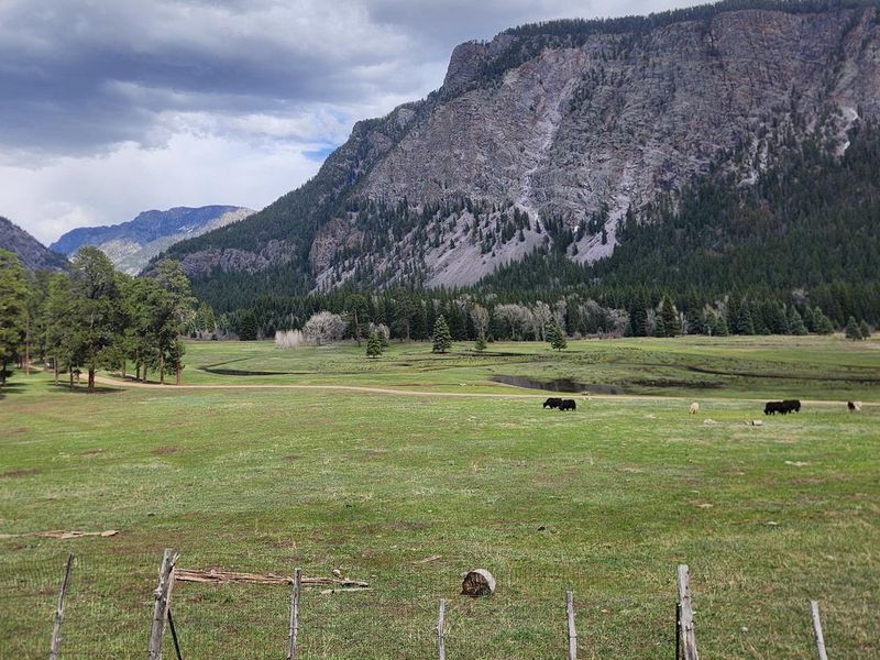
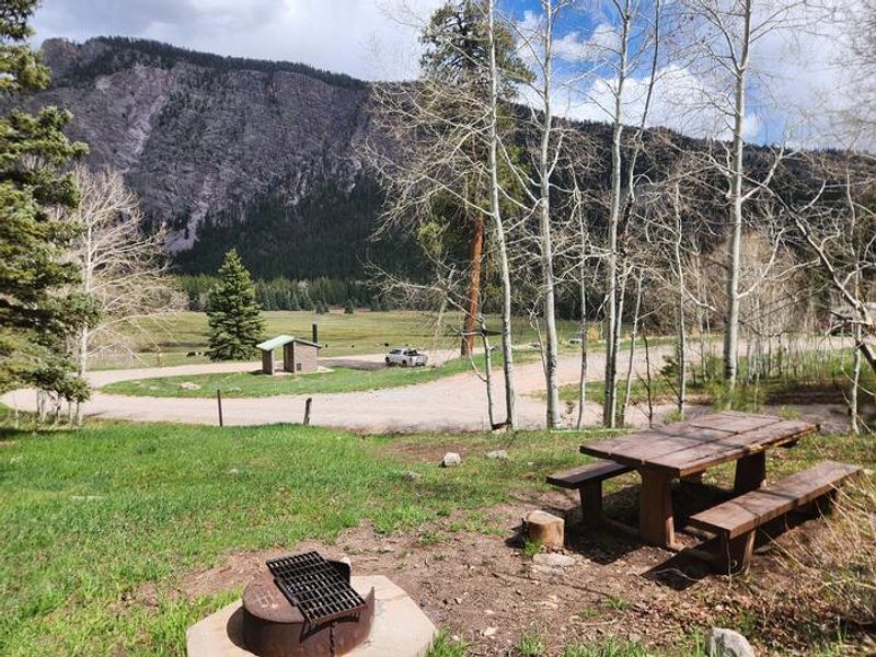
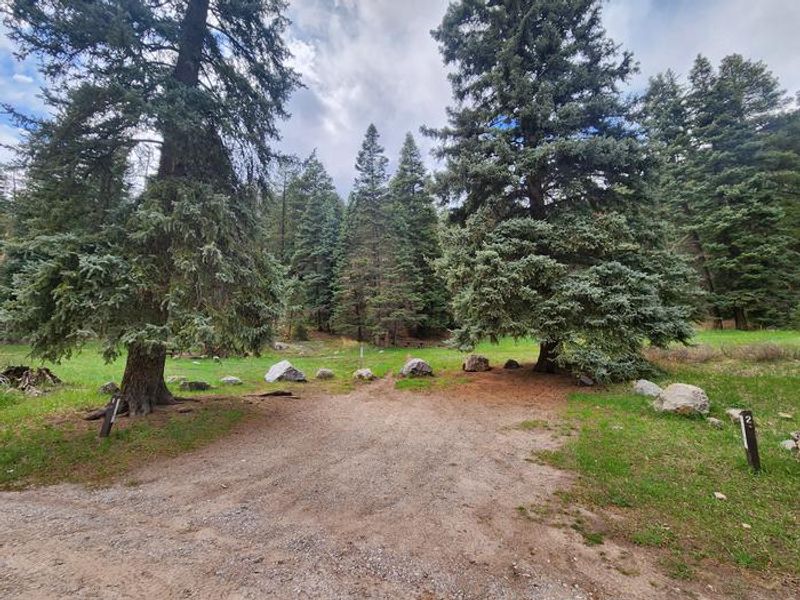
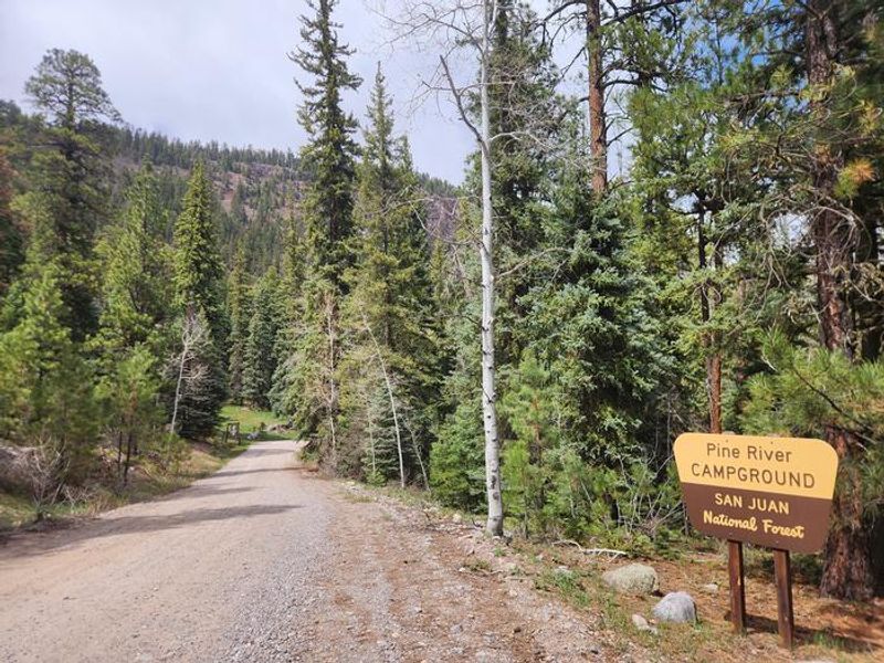
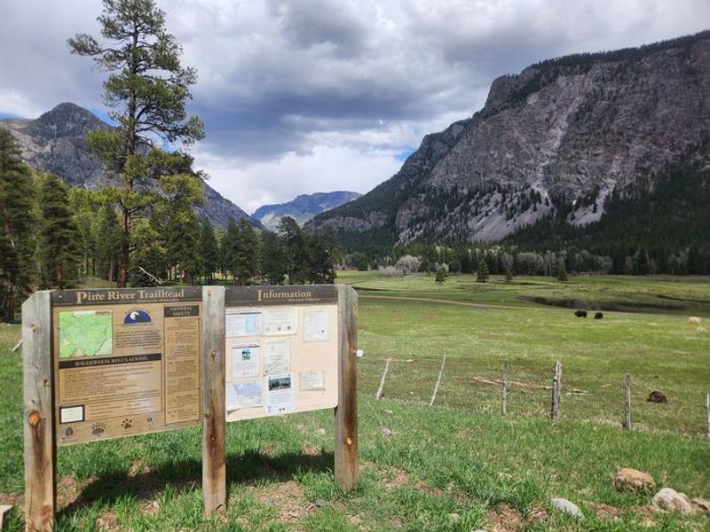
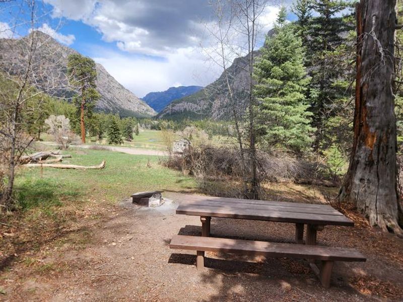
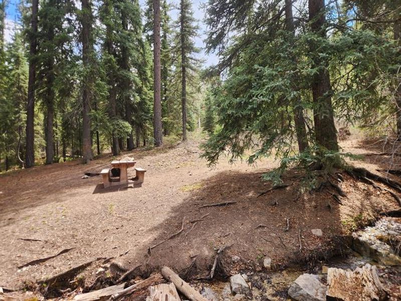
Pine River Campground is a primitive, 6-site campground located at the terminus of Forest Road 602 in the Columbine Ranger District of San Juan National Forest. Situated adjacent to the Pine River Trailhead, it serves primarily as a base camp for hikers and backpackers accessing Pine River Trail #523 and the Weminuche Wilderness. All campsites offer views up the Pine River Valley, though private land adjoins the campground with no public river access until three miles up the trail. The campground accommodates tents and small RVs up to 16 feet only. Sites must fit within the parking spur, and no overflow parking is available. Facilities are minimal: a single vault toilet at the trailhead and picnic tables. There is no potable water, so campers must bring their own supply. Quiet hours are 10pm to 6am, and generator use is limited to one hour at a time. Horses are prohibited within the campground itself, but the Pine River Trailhead offers a separate parking area with a horse corral for overnight horse camping, hitching posts, and trailer turnaround space. Dogs are permitted but must be leashed at all times and never left unattended.

Directions

From Durango: Travel 17 miles on Florida Road (County Road 240), turn left onto County Road 501 for approximately 13 miles to Middle Mountain Campground, then continue 4 miles to the campground entrance. From Bayfield: Travel 22 miles north on County Road 501 to Middle Mountain Campground, then continue 4 miles.

Amenities

Water No
Fires Allowed
Toilets Yes
Dump Station No
Wifi No
Pets Allowed Yes
Showers No
Electric Hookups
Water Hookups
Sewer Hookups
Camp Store No
Price $18

Vehicle

Max RV Length 16ft
Max Trailer Length
Big Rig Friendly No
Pull Through Sites No

Contact

Phone +1 (970) 884-2512

Cell Service

AT&T None
Verizon None
T-Mobile None

Availability

Photos

Overlooking Granite Peaks Ranch, Yaks grazing in meadow.
Site 6, park at lot and walk in
shared parking  for sites 1 & 2 located just above  - could fit small RV, Additional parking at trailhead lot
Pine River Campground entrance sign
Pine River Trailhead at campground
Site 5, looking towards Granite Peaks Ranch
Site 4, located a short walk and hop across the stream

Community Posts

No posts yet. Be the first to share your experience!