Hickory Ridge Campground
Open year-round, first-come-first-served, free of charge. No reservations accepted. Note: Trail 16 is currently closed between its two junctions with Trail 17. Horse riders and mountain bikers 17+ must have a permit.
Flood Warning issued May 22 at 11:56AM EDT until May 27 at 4:40PM EDT by NWS Indianapolis IN
...The Flood Warning is extended for the following rivers in Indiana... East Fork White River near Rivervale, Seymour, Bedford, Williams. .Multiple rounds of heavy rainfall over the last few days has brought minor to moderate flooding to the East Fork White. The crest on the East Fork is slightly past Seymour. Flooding along the lower East Fork is expected to last through most of next week. More rounds of rainfall the next few days, mainly Friday and Friday night, could make the flooding last longer and bring higher crests for downriver points. * WHAT...Moderate flooding is occurring and moderate flooding is forecast. * WHERE...East Fork White River at Seymour. * WHEN...Until Wednesday afternoon. * IMPACTS...At 17.5 feet, Extensive agricultural flooding in progress. CR 850 S and SR 11 begin to flood in southern Bartholomew County. During August 2009, SR 11 closed between Southern Crossing and Bartholomew CR 550 S. Columbus gage height was 9 feet. * ADDITIONAL DETAILS... - At 10:45 AM EDT Friday the stage was 17.3 feet. - Recent Activity...The maximum river stage in the 24 hours ending at 10:45 AM EDT Friday was 18.0 feet. - Forecast...The river is expected to fall below flood stage early Wednesday morning and continue falling and remain below flood stage. - Flood stage is 12.0 feet. - http://www.weather.gov/safety/flood
Flood Warning issued May 22 at 11:56AM EDT until June 1 at 1:00AM EDT by NWS Indianapolis IN
...The Flood Warning is extended for the following rivers in Indiana... East Fork White River near Rivervale, Seymour, Bedford, Williams. .Multiple rounds of heavy rainfall over the last few days has brought minor to moderate flooding to the East Fork White. The crest on the East Fork is slightly past Seymour. Flooding along the lower East Fork is expected to last through most of next week. More rounds of rainfall the next few days, mainly Friday and Friday night, could make the flooding last longer and bring higher crests for downriver points. * WHAT...Minor flooding is occurring and minor flooding is forecast. * WHERE...East Fork White River near Rivervale. * WHEN...Until Monday, June 01. * IMPACTS...At 28.0 feet, Extensive river flooding in progress. Residential areas near the river begin to flood. The county bridge locally known as the Buddha bypass bridge becomes inaccessible. Several local roads are flooded including Duncan Rd/Tunnelton Rd, Fort Ritner at the underpass and post office, Old Buddha Rd, Tunnelton Rd at the railroad crossing and West Sparksville Bridge Rd. * ADDITIONAL DETAILS... - At 11:30 AM EDT Friday the stage was 21.3 feet. - Recent Activity...The maximum river stage in the 24 hours ending at 11:30 AM EDT Friday was 21.3 feet. - Forecast...The river is expected to rise to a crest of 27.4 feet early Monday morning. It will then fall below flood stage Sunday, May 31. - Flood stage is 20.0 feet. - http://www.weather.gov/safety/flood
Flood Warning issued May 22 at 11:56AM EDT until May 31 at 5:36AM EDT by NWS Indianapolis IN
...The Flood Warning is extended for the following rivers in Indiana... East Fork White River near Rivervale, Seymour, Bedford, Williams. .Multiple rounds of heavy rainfall over the last few days has brought minor to moderate flooding to the East Fork White. The crest on the East Fork is slightly past Seymour. Flooding along the lower East Fork is expected to last through most of next week. More rounds of rainfall the next few days, mainly Friday and Friday night, could make the flooding last longer and bring higher crests for downriver points. * WHAT...Minor flooding is forecast. * WHERE...East Fork White River near Bedford. * WHEN...From this evening to Sunday, May 31. * IMPACTS...At 25.0 feet, Extensive lowland flooding is in progress. Bedford boat club is accessed by boat only. Some local residents walk to their homes. Several roads are closed including SR 450 east of Williams and Stumphole Bridge Rd. in Western Lawrence County. * ADDITIONAL DETAILS... - At 8:00 AM EDT Friday the stage was 18.6 feet. - Forecast...The river is expected to rise above flood stage late this evening to a crest of 24.9 feet early Monday afternoon. It will then fall below flood stage Saturday, May 30. - Flood stage is 20.0 feet. - http://www.weather.gov/safety/flood
Flood Warning issued May 22 at 11:56AM EDT until May 31 at 10:00AM EDT by NWS Indianapolis IN
...The Flood Warning is extended for the following rivers in Indiana... East Fork White River near Rivervale, Seymour, Bedford, Williams. .Multiple rounds of heavy rainfall over the last few days has brought minor to moderate flooding to the East Fork White. The crest on the East Fork is slightly past Seymour. Flooding along the lower East Fork is expected to last through most of next week. More rounds of rainfall the next few days, mainly Friday and Friday night, could make the flooding last longer and bring higher crests for downriver points. * WHAT...Minor flooding is forecast. * WHERE...East Fork White River at Williams. * WHEN...From late tonight to Sunday, May 31. * IMPACTS...At 12.0 feet, River begins to be noticeable as water backs up in local streams. State Road 450 closes in several locations. Higher campgrounds flood. Most roads in the flood plain are impassable above this level. Huron-Williams Road begins to flood south of Port Williams Road. * ADDITIONAL DETAILS... - There is no current observed data. - Forecast...The river is expected to rise above flood stage late tonight to a crest of 11.8 feet early Monday afternoon. It will then fall below flood stage Saturday, May 30. - Flood stage is 8.0 feet. - http://www.weather.gov/safety/flood
Mano Point boat launch is sedimented in
Mano Point boat launch is sedimented in due to high water levels this spring on the Ohio River.
Offices Closed April 29
Staff will be conducting a forest-wide clean up on April 29 and our Tell City and Bedford Offices will be closed. Offices will reopen on Thursday, April 30 at 8 a.m. local time. If you need assistance, visit our website at www.fs.usda.gov/R09/Hoosier
Acts Prohibited within the Charles C. Deam Wilderness
The following acts and omissions are prohibited in the Charles C. Deam Wilderness Area of the Hoosier National Forest.
Hoosier National Forest fire, camping, motor vehicle use, trail use, occupancy and use prohibitions
The following act(s) is/are prohibited within the Hoosier National Forest
Seasonal Cave Closure in Effect
All Hoosier National Forest caves are closed to visitors from August 16 and May 14 to prevent the disturbance of hibernating bats and reduce the spread of White-Nose syndrome in bats.We use the Code of Federal Regulations which defines a cave as - "Cave means any naturally occurring void, cavity,…
Rainbow Lake Area Closure
This Order restricts access to an 2.33-acre area, consisting of a 100 foot no activity buffer from the Northwestern cliff edges of East Rainbow Lake as identified in Exhibit A.
Hickory Ridge Trail 16 Closed
Hickory Ridge Trail 16 is currently closed from the junction of trail 17 on the west to junction with trail 17 on the east, south of trail 17.
Section of Tower Ridge Road temporarily closed for safety
A section of Tower Ridge Road was closed to the public on July 3, 2025 due to its deteriorating condition from storm damage and the hazards that posed to the public. Blackwell Campground can be accessed from the west. For Grubb Ridge Trailhead, Hickory Ridge Lookout Tower and points east, use…
Tipsaw Trail Bridge Closed Temporarily
Bridge #3 on Tipsaw Trail at Tipsaw Lake Recreation Area failed inspection and is closed for public safety. The trail remains open and visitors can bypass the bridge if they feel safe doing so.
Peninsula Trail Closed
The Peninsula Trail and Campsites 12 and 21 will remain closed until further notice. A severe storm in June 2024 caused significant damage.
About
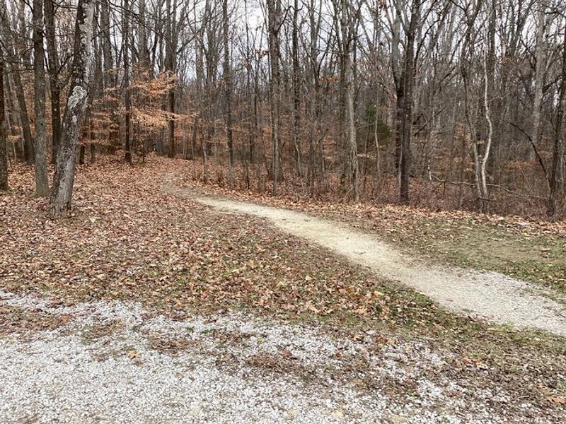
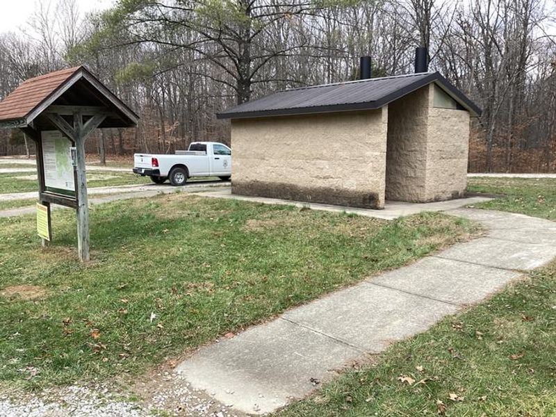
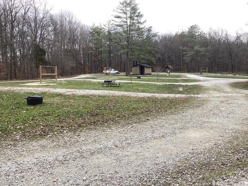
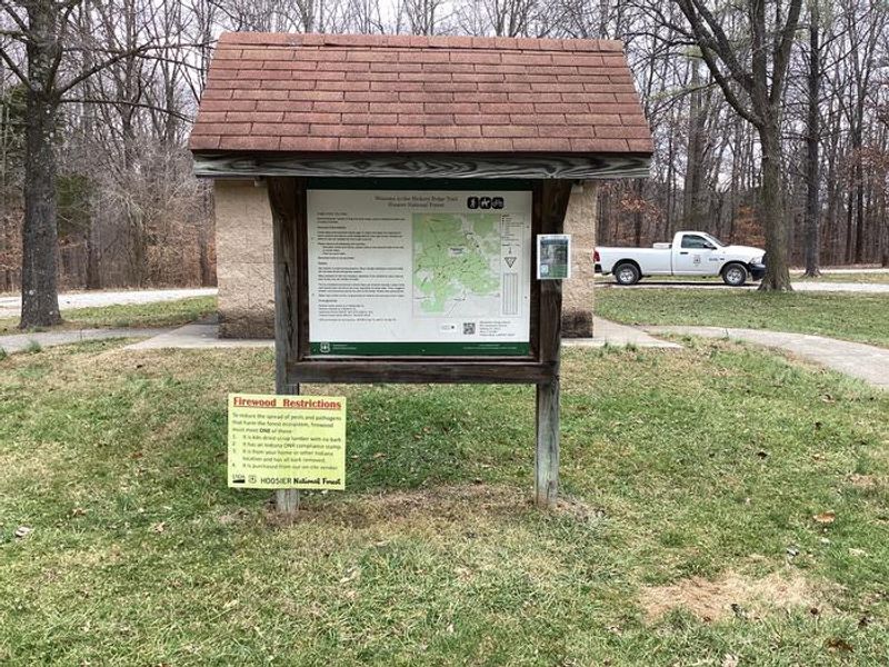
Hickory Ridge Campground is a primitive horse camp located in the rolling hardwood forests of Hoosier National Forest in Lawrence County, Indiana. The campground features 10 designated sites, each with a picnic table and fire ring, and is open year-round at no cost on a first-come, first-served basis. Facilities include accessible vault toilets, hitching racks, a mounting ramp, and a water trough for livestock. There is no potable water, so campers must bring their own drinking water. The campground serves as the primary access point for the Hickory Ridge Trail system, which offers approximately 46 miles of interconnecting loops through scenic hardwood forest. The trails are open to horseback riding, mountain biking, and hiking. Horse riders and mountain bikers aged 17 and older are required to obtain a permit, available from the Brownstown Ranger District office or local vendors. Firewood may be gathered from dead, downed material on site, but firewood from outside the area is prohibited to prevent the spread of invasive pests. Standing trees, whether living or dead, may not be cut or defaced. The campground also features a day-use parking area for trail users who are not camping overnight.
Directions
From IN-446, turn east on IN-58 and proceed 6.5 miles to Norman. Turn left at the stop sign to continue on IN-58. Proceed another 0.3 miles and turn left onto County Road 1250 W at the brown Forest Service sign. Continue 2.2 miles to the Hickory Ridge Trailhead/Campground on your left.
Amenities
| Water | No |
| Fires Allowed | Yes |
| Toilets | Yes |
| Dump Station | No |
| Wifi | No |
| Pets Allowed | — |
| Showers | No |
| Electric Hookups | — |
| Water Hookups | — |
| Sewer Hookups | — |
| Camp Store | No |
| Price | $0 |
Vehicle
| Max RV Length | — |
| Max Trailer Length | — |
| Big Rig Friendly | No |
| Pull Through Sites | No |
Contact
| SM.FS.R9HOFwebsite@usda.gov | |
| Phone | +1 (812) 275-5987 |
Cell Service
| AT&T | Yes |
| Verizon | Yes |
| T-Mobile | None |
Availability
Photos
Community Posts
No posts yet. Be the first to share your experience!