Sugar Bottom Day Use Area
This is a day-use only facility with no overnight camping. Picnic shelters and the surrounding area must be cleaned and vacated by sunset. Shelters are available first-come, first-served at no charge. For overnight camping, use the adjacent Sugar Bottom Campground.
Flash Flood Warning issued September 20 at 3:08AM CDT until September 20 at 8:00AM CDT by NWS Quad Cities IA IL
At 308 AM CDT, Doppler radar indicated thunderstorms producing heavy rain across the warned area. Between 1 and 2 inches of rain have fallen. Additional rainfall amounts of 1 to 3 inches are possible in the warned area. Flash flooding is ongoing or expected to begin shortly. HAZARD...Flash flooding caused by thunderstorms. SOURCE...Radar indicated. IMPACT...Flash flooding of small creeks and streams, urban areas, highways, streets and underpasses as well as other poor drainage and low-lying areas. Some locations that will experience flash flooding include... Cedar Rapids, Anamosa, Vinton, Marengo, Mechanicsville, Stanwood, Marion, Hiawatha, Mount Vernon, Robins, Belle Plaine, Center Point, Lisbon, Fairfax, Solon, Ely, Atkins, Walford, Springville and Palo. This includes Interstate 380 between mile markers 8 and 36.
Flash Flood Warning issued September 20 at 1:45AM CDT until September 20 at 6:15AM CDT by NWS Quad Cities IA IL
At 145 AM CDT, Trained weather spotters reported the creek in Kalona, Iowa is out of its banks and still rising. Between 1 and 2 inches of rain have fallen. Additional rainfall amounts of 1 to 3 inches are possible in the warned area as additional storms move through the area. HAZARD...Flash flooding caused by thunderstorms. SOURCE...Trained spotters reported. IMPACT...Flash flooding of small creeks and streams, urban areas, highways, streets and underpasses as well as other poor drainage and low-lying areas. Some locations that will experience flash flooding include... Iowa City, Muscatine, Washington, Tipton, Marengo, West Branch, Sigourney, Columbus Junction, Durant, Coralville, North Liberty, West Liberty, Williamsburg, Wilton, Kalona, Tiffin, Wellman, Lone Tree and University Heights. This includes the following highways... Interstate 80 in Iowa between mile markers 205 and 277. Interstate 380 between mile markers 1 and 7.
Flood Watch issued September 20 at 1:44AM CDT until September 20 at 1:00PM CDT by NWS Quad Cities IA IL
* WHAT...Flooding and flash flooding caused by excessive rainfall is possible. * WHERE...Portions of Illinois, including the following areas, Bureau, Carroll, Henry IL, Jo Daviess, Mercer, Putnam, Rock Island, Stephenson and Whiteside and Iowa, including the following areas, Benton, Buchanan, Cedar, Clinton, Delaware, Dubuque, Iowa, Jackson, Johnson, Jones, Keokuk, Linn, Louisa, Muscatine, Scott and Washington. * WHEN...Until 1 PM CDT this afternoon. * IMPACTS...Excessive runoff may result in flooding of rivers, creeks, streams, and other low-lying and flood-prone locations. Flooding may occur in poor drainage and urban areas. * ADDITIONAL DETAILS... - Widespread showers and storms will continue to move across the watch area through at least late Sunday morning. These storms will be capable of rainfall rates between 1 to 2 inches per hour. Rainfall totals of 1 to 3 inches are likely in the hardest hit areas, with the potential for localized areas of 4 to 5 inches.
About
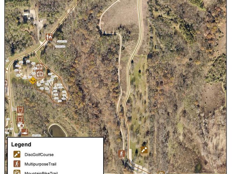
Sugar Bottom Day Use Area sits among heavily wooded mixed hardwood forest on the east side of Coralville Lake in Johnson County, Iowa. The facility features large group picnic shelters equipped with drinking water and electricity, a swimming beach, playground, and flush restrooms. Shelters are available first-come, first-served at no charge, though special event permits are required for large gatherings. Recreational opportunities include the Sugar Bottom Disc Golf Course with 18 partially wooded and open holes, and the Sugar Bottom Mountain Bike Trail system with routes for all skill levels. The Cedar Valley Nature Trail and a barrier-free asphalt path also run through the area. The nearby Devonian Fossil Gorge below the dam offers a unique opportunity to explore a 375-million-year-old sea floor. This is a day-use facility only and must be vacated by sunset. Overnight camping is not permitted here; visitors seeking to camp should reserve sites at the adjacent Sugar Bottom Campground.
Directions
From Interstate 380 (North Liberty, Iowa), take Exit 4 towards North Liberty. Travel east on W. Penn St. for 2.2 miles. At the four-way stop sign, turn left onto N. Front St./Mehaffey Bridge Road NE. Continue on Mehaffey Bridge Rd. NE for 2.9 miles. Right after crossing the Mehaffey Bridge, turn right onto Sugar Bottom Campground Access Rd. Continue for 1.1 miles; entrance to Sugar Bottom Day Use Area will be on the left.
Amenities
| Water | Yes |
| Fires Allowed | — |
| Toilets | Yes |
| Dump Station | — |
| Wifi | — |
| Pets Allowed | Yes |
| Showers | — |
| Electric Hookups | — |
| Water Hookups | — |
| Sewer Hookups | — |
| Camp Store | — |
| Price | $50 |
Vehicle
| Max RV Length | — |
| Max Trailer Length | — |
| Big Rig Friendly | — |
| Pull Through Sites | No |
Contact
| Phone | +1 (319) 338-3543 |
Cell Service
| AT&T | Yes |
| Verizon | Yes |
| T-Mobile | None |
Availability
Photos
Community Posts
No posts yet. Be the first to share your experience!