Cottonwood Campground
The campground was closed for the entire 2025 recreation season and remains closed as of late May 2026. Normal operating season is May 1 through October 31. Reservations are handled through Recreation.gov when open.
Flood Watch issued June 11 at 10:10AM CDT until June 11 at 7:00PM CDT by NWS Quad Cities IA IL
Several rounds of heavy rain producing thunderstorms will be seen across the watch area. Storms may redevelop over the same areas resulting torrential rainfall and possibly several inches of rain. Flash flooding will be possible through this evening. * WHAT...Flooding caused by excessive rainfall continues to be possible. * WHERE...Portions of Illinois, including the following areas, Bureau, Carroll, Hancock, Henderson, Henry IL, Jo Daviess, McDonough, Mercer, Putnam, Rock Island, Stephenson, Warren and Whiteside, Iowa, including the following areas, Benton, Buchanan, Cedar, Clinton, Delaware, Des Moines, Dubuque, Henry IA, Iowa, Jackson, Jefferson, Johnson, Jones, Keokuk, Lee, Linn, Louisa, Muscatine, Scott, Van Buren and Washington, and northeast Missouri, including the following areas, Clark and Scotland. * WHEN...Until 7 PM CDT this evening. * IMPACTS...Excessive runoff may result in flooding of rivers, creeks, streams, and other low-lying and flood-prone locations. Creeks and streams may rise out of their banks.
Flood Warning issued June 11 at 9:52AM CDT until June 13 at 11:43PM CDT by NWS Quad Cities IA IL
...The Flood Warning continues for the following rivers in Iowa... Maquoketa River near Maquoketa affecting Jackson County. Cedar River near Conesville affecting Louisa and Muscatine Counties. Iowa River near Lone Tree affecting Louisa, Washington and Johnson Counties. English River at Kalona affecting Washington and Johnson Counties. Skunk River at Augusta affecting Henry IA, Des Moines and Lee Counties. Wapsipinicon River near De Witt 4S affecting Scott and Clinton Counties. ...The Flood Warning is extended for the following rivers in Illinois... Rock River near Joslin affecting Henry IL, Rock Island and Whiteside Counties. Rock River at Moline affecting Henry IL and Rock Island Counties. .Several rounds of heavy rainfall will produce flooding on several tributary rivers. * WHAT...Minor flooding is forecast. * WHERE...English River at Kalona. * WHEN...From late tonight to late Saturday evening. * IMPACTS...At 16.0 feet, Water begins approaching several county roads. Agricultural land near the river is flooding. * ADDITIONAL DETAILS... - At 9:00 AM CDT Thursday the stage was 7.6 feet. - Forecast...The river is expected to rise above flood stage late tonight to a crest of 15.9 feet tomorrow evening. It will then fall below flood stage Saturday afternoon. - Flood stage is 14.0 feet.
Flood Warning issued June 11 at 9:52AM CDT until June 12 at 9:36PM CDT by NWS Quad Cities IA IL
...The Flood Warning continues for the following rivers in Iowa... Maquoketa River near Maquoketa affecting Jackson County. Cedar River near Conesville affecting Louisa and Muscatine Counties. Iowa River near Lone Tree affecting Louisa, Washington and Johnson Counties. English River at Kalona affecting Washington and Johnson Counties. Skunk River at Augusta affecting Henry IA, Des Moines and Lee Counties. Wapsipinicon River near De Witt 4S affecting Scott and Clinton Counties. ...The Flood Warning is extended for the following rivers in Illinois... Rock River near Joslin affecting Henry IL, Rock Island and Whiteside Counties. Rock River at Moline affecting Henry IL and Rock Island Counties. .Several rounds of heavy rainfall will produce flooding on several tributary rivers. * WHAT...Minor flooding is forecast. * WHERE...Iowa River near Lone Tree. * WHEN...From Friday morning to late tomorrow evening. * IMPACTS...At 16.0 feet, Flood waters affect parts of Lola Lane and Y Avenue. River Junction Access Park is closed. * ADDITIONAL DETAILS... - At 9:00 AM CDT Thursday the stage was 11.2 feet. - Forecast...The river will rise above flood stage late tomorrow morning to 16.1 feet early tomorrow afternoon. It will then fall below flood stage early tomorrow afternoon to 13.4 feet Saturday morning. It will rise to 13.8 feet early Sunday morning. It will then fall again and remain below flood stage. - Flood stage is 16.0 feet.
Tornado Watch issued June 11 at 7:33AM CDT until June 11 at 3:00PM CDT by NWS Quad Cities IA IL
THE NATIONAL WEATHER SERVICE HAS ISSUED TORNADO WATCH 311 IN EFFECT UNTIL 3 PM CDT THIS AFTERNOON FOR THE FOLLOWING AREAS IN ILLINOIS THIS WATCH INCLUDES 13 COUNTIES IN NORTH CENTRAL ILLINOIS BUREAU PUTNAM IN NORTHWEST ILLINOIS CARROLL HENRY IL JO DAVIESS MERCER ROCK ISLAND STEPHENSON WHITESIDE IN WEST CENTRAL ILLINOIS HANCOCK HENDERSON MCDONOUGH WARREN IN IOWA THIS WATCH INCLUDES 21 COUNTIES IN EAST CENTRAL IOWA BENTON CEDAR CLINTON IOWA JACKSON JOHNSON JONES LINN MUSCATINE SCOTT IN NORTHEAST IOWA BUCHANAN DELAWARE DUBUQUE IN SOUTHEAST IOWA DES MOINES HENRY IA JEFFERSON KEOKUK LEE LOUISA VAN BUREN WASHINGTON IN MISSOURI THIS WATCH INCLUDES 2 COUNTIES IN NORTHEAST MISSOURI CLARK SCOTLAND THIS INCLUDES THE CITIES OF ALEDO, ANAMOSA, BETTENDORF, BURLINGTON, CARTHAGE, CEDAR RAPIDS, CLINTON, CREDIT ISLAND, DAVENPORT, DUBUQUE, FAIRFIELD, FREEPORT, GALENA, GENESEO, HENNEPIN, INDEPENDENCE, IOWA CITY, KAHOKA, KEOKUK, KEOSAUQUA, MACOMB, MANCHESTER, MAQUOKETA, MARENGO, MEMPHIS, MOLINE, MONMOUTH, MOUNT CARROLL, MOUNT PLEASANT, MUSCATINE, OQUAWKA, PRINCETON, ROCK ISLAND, SIGOURNEY, STERLING, TIPTON, VINTON, WAPELLO, AND WASHINGTON.
About
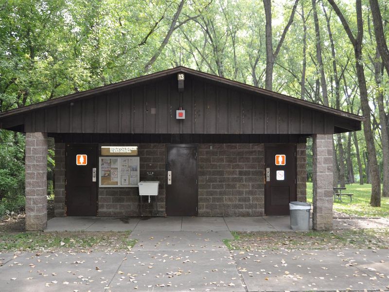
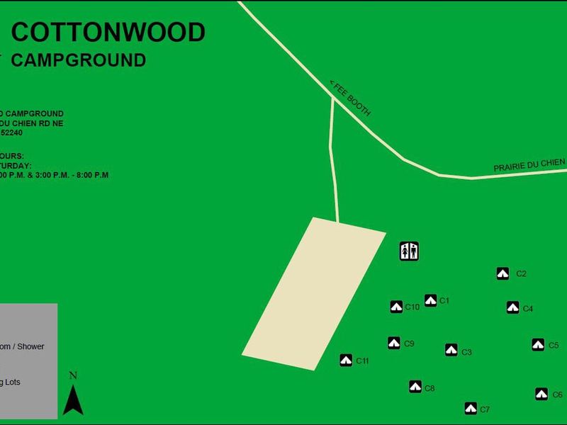
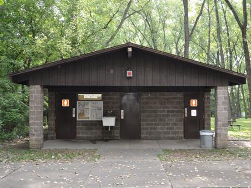
Cottonwood Campground offers a primitive tent camping experience within the Dam Complex at Coralville Lake, just north of Iowa City. The 11 walk-to sites accommodate up to 6 people and 3 tents each, set among a heavily wooded forest of mixed hardwood species. This is tent-only camping with no vehicle access to sites and no electric hookups. Modern amenities are available at the main parking lot, including a restroom and shower facility. Drinking water and a dump station are located outside the nearby West Overlook Campground. Trash and recycling receptacles are provided on-site. Coralville Lake provides excellent recreational opportunities including boating, fishing for largemouth and smallmouth bass, crappie, walleye, and catfish, swimming, and water skiing. The nearby Devonian Fossil Gorge offers a unique chance to explore a 375-million-year-old sea floor. Several trails are accessible from the Dam Complex, including the barrier-free Veterans Trail.
Directions
From I-80 in Iowa City, take Exit 244 toward Dubuque St./North Liberty. Travel north on Dubuque St. for 3 miles and turn right onto West Overlook Rd. NE. Travel 1.1 miles to the second stop sign, turn right onto Prairie Du Chien Rd. NE. The campground entrance is 0.1 miles on the right.
Nearby Campgrounds
Amenities
| Water | Yes |
| Fires Allowed | — |
| Toilets | Yes |
| Dump Station | Yes |
| Wifi | — |
| Pets Allowed | Yes |
| Showers | Yes |
| Electric Hookups | — |
| Water Hookups | — |
| Sewer Hookups | — |
| Camp Store | — |
| Price | $14 |
Vehicle
| Max RV Length | — |
| Max Trailer Length | — |
| Big Rig Friendly | No |
| Pull Through Sites | No |
Contact
| coralville.lake@usace.army.mil | |
| Phone | +1 (319) 338-3543 |
Cell Service
| AT&T | Yes |
| Verizon | Yes |
| T-Mobile | None |
Availability
Photos
Community Posts
No posts yet. Be the first to share your experience!