Open year-round. Backcountry permits required via Recreation.gov. Pets prohibited in wilderness areas.
Flash Flood Warning issued July 21 at 3:02PM MST until July 21 at 6:00PM MST by NWS Tucson AZ
FFWTWC The National Weather Service in Tucson has issued a * Flash Flood Warning for... Western Cochise County in southeastern Arizona... East Central Pima County in southeastern Arizona... * Until 600 PM MST. * At 302 PM MST, Doppler radar indicated thunderstorms producing heavy rain across the warned area. Between 1 and 2 inches of rain have fallen. Additional rainfall amounts of 1 to 2 inches are possible in the warned area. Flash flooding is ongoing or expected to begin shortly. HAZARD...Life threatening flash flooding. Thunderstorms producing flash flooding. SOURCE...Radar indicated. IMPACT...Life threatening flash flooding of creeks and streams, urban areas, highways, streets and underpasses. * Some locations that will experience flash flooding include... Mescal. This includes Interstate 10 between mile markers 283 and 301.
Flash Flood Warning issued July 21 at 2:25PM MST until July 21 at 5:30PM MST by NWS Tucson AZ
FFWTWC The National Weather Service in Tucson has issued a * Flash Flood Warning for... West Central Cochise County in southeastern Arizona... East Central Pima County in southeastern Arizona... * Until 530 PM MST. * At 225 PM MST, Doppler radar indicated thunderstorms producing heavy rain across the warned area. Up to 1 inch of rain has fallen. Additional rainfall amounts of 1 to 2 inches are possible in the warned area. Flash flooding is ongoing or expected to begin shortly. HAZARD...Flash flooding caused by thunderstorms. SOURCE...Radar indicated. IMPACT...Flash flooding of small creeks and streams, urban areas, highways, streets and underpasses as well as other poor drainage and low-lying areas. * Some locations that will experience flash flooding include... Benson and St. David. This includes the following highways... Route 90 between mile markers 290 and 293. Route 80 between mile markers 293 and 299. Interstate 10 between mile markers 302 and 313.
Flood Advisory issued July 21 at 3:26PM MST until July 21 at 6:30PM MST by NWS Tucson AZ
* WHAT...Flooding caused by excessive rainfall is expected. * WHERE...Northwestern Cochise County in southeastern Arizona... Northeastern Pima County in southeastern Arizona... Southern Pinal County in southeastern Arizona... * WHEN...Until 630 PM MST. * IMPACTS...Minor flooding in low-lying and poor drainage areas. Rises in small streams and normally dry washes. * ADDITIONAL DETAILS... - At 326 PM MST, Doppler radar indicated heavy rain due to thunderstorms. Minor flooding is ongoing or expected to begin shortly in the advisory area. Up to 1 inch of rain has fallen. - Additional rainfall amounts up to 1 inch are expected over the area. This additional rain will result in minor flooding. Expect water to fill washes within the Santa Catalina Mountains and near Catalina State Park. - Some locations that will experience flooding include... Catalina, Oro Valley, Saddlebrooke, Tortolita, Mount Lemmon/Summerhaven, Saguaro National Park East, Catalina State Park, Redington and Cascabel. - This includes Route 77 between mile markers 81 and 90. This includes the following Flash Flood Prone Locations... E Wilds Rd at the Canada del Oro. - http://www.weather.gov/safety/flood
About
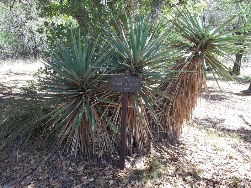
Grass Shack sits at 5,300 feet in the Saguaro Wilderness, offering three backcountry campsites beneath large oaks and junipers. Chimenea Creek, the largest watershed in the Rincon Mountains, runs through the campground and provides water most of the year. The shaded riparian setting makes this one of the more comfortable wilderness camps in the park. The approach from Camino Loma Alta covers 10 miles with 2,200 feet of elevation gain, climbing through and above the saguaro forests. The route offers exceptional southern views and the campground is often unaffected by winter storms. Cell service is inconsistent; hikers may need to climb 0.5-1 mile to find signal. Each site accommodates up to 6 people and includes tent pads and a bear box for food storage. A vault toilet serves the campground. Campfires are strictly prohibited due to the fragile riparian ecosystem and surrounding grasslands susceptible to wildfire; gas stoves are encouraged.
Directions
Access from Camino Loma Alta trailhead. The 10-mile hike gains 2,200 feet of elevation climbing through the Rincon Mountains.
Location
Amenities
| Water | No |
| Fires Allowed | No |
| Toilets | Yes |
| Dump Station | No |
| Wifi | No |
| Pets Allowed | No |
| Showers | No |
| Electric Hookups | — |
| Water Hookups | — |
| Sewer Hookups | — |
| Camp Store | No |
| Price | $4 - $8 |
Vehicle
| Max RV Length | — |
| Max Trailer Length | — |
| Big Rig Friendly | No |
| Pull Through Sites | No |
Contact
| Phone | +1 (520) 733-5153 |
Cell Service
| AT&T | None |
| Verizon | Yes |
| T-Mobile | None |
Photos
Community Posts
No posts yet. Be the first to share your experience!