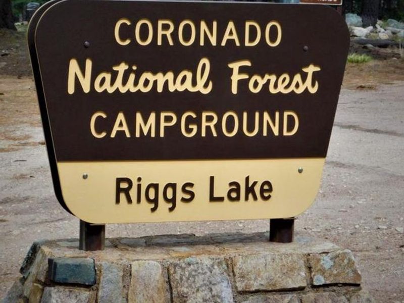
Riggs Lake
Closed — Closed for the winter season. Swift Trail (AZ 366) closes November 15 and typically reopens around April 15, weather permitting. No water available during shoulder seasons.
Fireworks, Explosives and Sparks Restrictions
To prevent fires and for public safety order 03-00-23-001 prohibits to 1) possess, discharge, or use any kind of firework or other pyrotechnic devices; 2) use explosives; or 3) operate an internal or external combustion engine without a spark arresting device in effective working order.
Motor Vehicle Order Road Restrictions
The purpose of this Order is for the protection of public health and safety and prohibits: Using any type of vehicle that does not comply with an applicable state law.Using a road for commercial hauling without a permit or written authorization.Operating a vehicle in violation of speed, load,…
Mount Graham Inclement Weather Road Closure
Pursuant to 16 U.S.C. § 551 and 36 C.F.R. § 261.50(b), the following acts are prohibited on the National Forest System (NFS) roads within the Safford Ranger District, Coronado National Forest, described below and shown on the attached map incorporated into this Order as Exhibit A, (“Described…
Fuelwood Sales
The minimum charge for a firewood permit is $20. Depending on the location and availability, for $20 you can select up to 10 cords of softwood or hardwood ($2/cord). The dates listed in the table below are subject to change depending on conditions and availability of wood. We recommend you…
Bear Wallow Riparian Area Closure
No camping, parking, bicycle travel, or campfires allowed in Bear Wallow Riparian Area
Target Shooting Refuse Restriction
Possessing or storing any refuse for the purpose of target shooting with a firearm, air rifle, or gas gun. 36 C.F.R. § 261.58(cc).
Jacobson Fire
In response to the Jacobson Fire that started on 5/26, areas are closed to visitor access. Inciweb:https://inciweb.wildfire.gov/incident-information/azcnf-jacobson-fire
Stronghold Fire
Stronghold Fire information is available at https://inciweb.wildfire.gov/incident-information/aza3s-stronghold-fire.
Meadow Valley Road Closure 03-05-03-25-005 (Phase 2)
The purpose of this Order is to protect public and worker safety on NFSR 765, as the newly constructed road section is surfaced with material.Prohibitions: Being on the Described Road. 36 C.F.R. § 261.54(e).
Meadow Valley Road Closure 03-05-03-25-004 (Phase 1)
The purpose of this Order is to protect public and worker safety on NFSR 765, as the newly constructed road section is surfaced with material.Prohibitions: Being on the Described Road. 36 C.F.R. § 261.54(e).
Sabino and Bear Canyon Closure Order 03-05-03-25-002
The purpose of this Order is to protect public health and safety and forest resources from environmental degradation.Effective January 22, 2025, through January 21, 2028, the Santa Catalina Ranger District has implemented a closure order in the area of Bear Canyon Trail and the Wilderness boundary…
14 Day Camping Closure 03-05-00-24-005
The purpose of this Order is to provide for public health and safety and to mitigate impacts on sensitive plant and wildlife species.
Alcohol Closure
The purpose of this Order is to comply with the Arizona and New Mexico state law and to restrict underage consumption of alcoholic beverages to provide for public health and safety.
Tanque Verde Falls Camping Closure
The purpose of this Order is to protect public health and safety and forest resources in the Described Area.
Barfoot Snake Closure Order 03-05-01-24-004
The twin-spotted rattlesnake (Crotalus pricei) is a Regional Forester’s Sensitive Species and a State of Arizona protected reptile. Due to this species’ extremely limited habitat and population numbers, this Order provides for the protection of this species by precluding entry into the…
Rose Canyon Lake Closure Order 03-05-05-23-022
The Coronado National Forest is renewing the closure of the surface of Rose Canyon Lake. The overall recreation area remains open and fishing from the shore is allowed.
Bear Wallow Riparian Area Closure Order 03-05-05-23-019
The purpose of this Order is to protect riparian ecosystem and water quality from the impacts of heavy recreation use in the Described Area. Recreation activities such as camping or offroad motor vehicle use can cause soil compactions and erosion, which is difficult to repair and can lead to…
SVRD Rec Shooting Closure Order 03-05-03-23-010
Discharging a firearm, air rifle, or gas gun in the Restricted Area.The Order shall remain in effect indefinitely, unless rescinded.
Olson Cabin Closure 03-05-05-22-030
Olson Cabin Permit Area is located on the west side of Forest System Road 4458 and approximately 1,500 feet northwest of the junction of Forest System Road 4458 and Forest System Road 639.There are many problems associated with the Olson Cabin Permit Area. The permit area and improvements were…
About
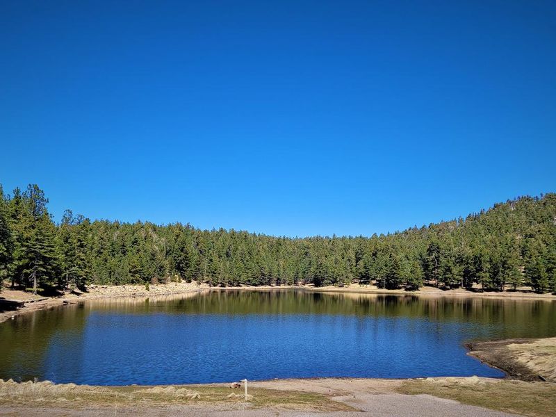
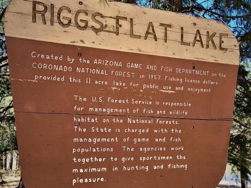
Riggs Flat Campground is located at the terminus of Swift Trail in the Pinaleno Mountains of the Coronado National Forest at an elevation of 9,800 feet. The campground surrounds the picturesque 11-acre Riggs Flat Lake, which was created in 1957 by the Arizona Game and Fish Department to provide alpine trout fishing opportunities. The cold waters are stocked during summer with rainbow, brown, and brook trout, with fishing season running from May through October. The campground operates seasonally from mid-April through mid-November, when the Swift Trail is accessible. The area is characterized by alpine forest and meadow, offering dramatic scenery including views of West Peak and distant vistas of Aravaipa Valley and the Galiuro Mountains. Small boats with electric trolling motors are permitted on the lake, though most anglers fish from shore. Each campsite includes a picnic table and fire pit. Access requires navigating 34 miles of winding mountain road from Safford, with the last 12 miles particularly narrow and challenging. Vehicles longer than 22 feet are not recommended due to tight switchbacks. This is active black bear habitat, and proper food storage is mandatory. The campground can be reserved through Recreation.gov, with sites priced at $20 per night for single sites.
Directions
From Safford, drive south 8 miles on US 191 to AZ 366/Swift Trail. Turn right and drive 29 miles to the Columbine Visitor Center. Continue along Forest Roads 803 and 287 for about 5 miles to the campground. The last 12 miles are narrow and winding with tight switchbacks.
Nearby Campgrounds
Amenities
| Water | Yes |
| Fires Allowed | Yes |
| Toilets | Yes |
| Dump Station | No |
| Wifi | No |
| Pets Allowed | Yes |
| Showers | No |
| Electric Hookups | No |
| Water Hookups | No |
| Sewer Hookups | No |
| Camp Store | No |
| Price | $50 |
Vehicle
| Max RV Length | 22ft |
| Max Trailer Length | 22ft |
| Big Rig Friendly | No |
| Pull Through Sites | No |
Contact
| samantha.malone@usda.gov | |
| Phone | +1 (928) 428-4150 |
Cell Service
| AT&T | None |
| Verizon | Yes |
| T-Mobile | None |
Useful Links
| View on Recreation.gov |
Availability
Photos
Community Posts
No posts yet. Be the first to share your experience!