Kiptopeke State Park Campground
Open from the first Friday in March through the first Monday in December. Reservations available via reservevaparks.com or by calling 1-800-933-PARK. The camp store operates seasonally from late May to mid-October.
Coastal Flood Watch issued September 22 at 6:28AM EDT until September 25 at 4:00AM EDT by NWS Wakefield VA
* WHAT...For the Beach Hazards Statement, a high risk of rip currents is expected. For the Coastal Flood Advisory, up to one foot of inundation above ground level expected in low- lying areas near shorelines and tidal waterways. For the High Surf Advisory, large breaking waves of 8 to 12 feet expected in the surf zone. For the Coastal Flood Watch, one to two feet of inundation above ground level possible in low-lying areas near shorelines and tidal waterways. * WHERE...The Maryland Beaches, Accomack, and Northampton County. * WHEN...For the Beach Hazards Statement, from 8 AM EDT this morning through Wednesday evening. For the Coastal Flood Advisory, from 4 PM this afternoon to 4 PM EDT Wednesday. For the High Surf Advisory, from 2 AM Wednesday to 6 PM EDT Thursday. For the Coastal Flood Watch, from Wednesday afternoon through late Thursday night. * IMPACTS...Numerous roads may be closed. Low lying property including homes, businesses, and some critical infrastructure may be inundated. Some shoreline erosion may occur. Dangerous swimming and surfing conditions and localized beach erosion.
Beach Hazards Statement issued September 22 at 6:28AM EDT until September 23 at 8:00PM EDT by NWS Wakefield VA
* WHAT...For the Beach Hazards Statement, a high risk of rip currents is expected. For the Coastal Flood Advisory, up to one foot of inundation above ground level expected in low- lying areas near shorelines and tidal waterways. For the High Surf Advisory, large breaking waves of 8 to 12 feet expected in the surf zone. For the Coastal Flood Watch, one to two feet of inundation above ground level possible in low-lying areas near shorelines and tidal waterways. * WHERE...The Maryland Beaches, Accomack, and Northampton County. * WHEN...For the Beach Hazards Statement, from 8 AM EDT this morning through Wednesday evening. For the Coastal Flood Advisory, from 4 PM this afternoon to 4 PM EDT Wednesday. For the High Surf Advisory, from 2 AM Wednesday to 6 PM EDT Thursday. For the Coastal Flood Watch, from Wednesday afternoon through late Thursday night. * IMPACTS...Numerous roads may be closed. Low lying property including homes, businesses, and some critical infrastructure may be inundated. Some shoreline erosion may occur. Dangerous swimming and surfing conditions and localized beach erosion.
High Surf Advisory issued September 22 at 6:28AM EDT until September 24 at 6:00PM EDT by NWS Wakefield VA
* WHAT...For the Beach Hazards Statement, a high risk of rip currents is expected. For the Coastal Flood Advisory, up to one foot of inundation above ground level expected in low- lying areas near shorelines and tidal waterways. For the High Surf Advisory, large breaking waves of 8 to 12 feet expected in the surf zone. For the Coastal Flood Watch, one to two feet of inundation above ground level possible in low-lying areas near shorelines and tidal waterways. * WHERE...The Maryland Beaches, Accomack, and Northampton County. * WHEN...For the Beach Hazards Statement, from 8 AM EDT this morning through Wednesday evening. For the Coastal Flood Advisory, from 4 PM this afternoon to 4 PM EDT Wednesday. For the High Surf Advisory, from 2 AM Wednesday to 6 PM EDT Thursday. For the Coastal Flood Watch, from Wednesday afternoon through late Thursday night. * IMPACTS...Numerous roads may be closed. Low lying property including homes, businesses, and some critical infrastructure may be inundated. Some shoreline erosion may occur. Dangerous swimming and surfing conditions and localized beach erosion.
About
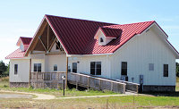
Kiptopeke State Park Campground occupies a scenic stretch of Virginia's Eastern Shore along the Chesapeake Bay, in an area first explored by Captain John Smith in 1608. Located just three miles from the northern terminus of the Chesapeake Bay Bridge-Tunnel, the campground serves as an excellent base for exploring the Delmarva Peninsula while enjoying direct bay access. The campground features 138 sites across multiple loops: 52 standard tent sites without hookups, 66 sites with electric and water, and 27 full-hookup sites with electric, water, and sewer connections. Four yurts provide a unique glamping option. All sites include a picnic table and fire ring. The A Loop and even-numbered B sites have electric and water only, while B-1, 3, 5, 7, 9, 11, 13, and all C Loop sites offer full sewer hookups. Electric service includes 20, 30, and 50-amp options. Campground bathhouses provide hot showers, flush restrooms, and coin-operated laundry with soap vending machines. A dump station serves RV campers. The seasonal camp store operates from late May through mid-October, offering firewood, ice, drinks, camping supplies, and kayak and bike rentals. Beyond camping, visitors enjoy the swimming beach, lighted fishing pier, boat ramp, picnic areas, playground, and over five miles of trails.
Directions
From Route 13 on Virginia's Eastern Shore, turn west on Route 704 (Kiptopeke Drive). The park entrance is within a half-mile. The park is three miles from the northern terminus of the Chesapeake Bay Bridge-Tunnel.
Nearby Campgrounds
Amenities
| Water | Yes |
| Fires Allowed | Yes |
| Toilets | Yes |
| Dump Station | Yes |
| Wifi | — |
| Pets Allowed | Yes |
| Showers | Yes |
| Electric Hookups | Yes |
| Water Hookups | Yes |
| Sewer Hookups | Yes |
| Camp Store | Yes |
| Price | $32 - $43 |
Vehicle
| Max RV Length | 91ft |
| Max Trailer Length | 40ft |
| Big Rig Friendly | Yes |
| Pull Through Sites | No |
Contact
| kiptopeke@dcr.virginia.gov | |
| Phone | +1 (757) 331-2267 |
Cell Service
| AT&T | Yes |
| Verizon | Yes |
| T-Mobile | Yes |
Availability
Photos
Community Posts
No posts yet. Be the first to share your experience!